
National Register of Historic Places listings in Mason County, West Virginia facts for kids

Have you ever wondered about the oldest and most special places in your community? In Mason County, West Virginia, there are many buildings, homes, and areas that are so important they are listed on the National Register of Historic Places. This is like a special list kept by the United States government to protect places that tell us about history.
These places are chosen because they are very old, have unique architecture, or played a big part in history. By being on this list, they get extra care to make sure they stay around for many more years. Let's explore some of these amazing historic spots right here in Mason County!
Contents
Historic Places in Mason County
Mason County is home to 12 different properties and areas that are recognized for their historical importance. Each one has a story to tell about the past.
Homes with History
Many of the places on the list are old houses. These homes often show us how people lived long ago and what kind of buildings were popular in different time periods.
- Couch-Artrip House: Located in Southside, this house was added to the list in 1984. It's a great example of an older home in the area.
- Eastham House: Also found in Point Pleasant, this house became historic in 1989.
- Elm Grove: This historic district in Southside was recognized in 1992. It likely includes a significant old home and its surrounding property.
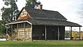
- The Gold Houses: These two houses in Mason, listed in 1997, are special because of their unique design or the people who lived there.
- Lewis-Capehart-Roseberry House: This house in Point Pleasant has been on the list since 1979. It's named after the families who lived there over time.
- Maplewood: In Pliny, this historic district was added in 2001. It probably features a beautiful old estate or a collection of historic buildings.
- Gen. John McCausland House: Near Leon, this house belonged to a famous general. It was listed in 1980 and later had its historic area expanded.
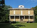
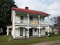
- Powell-Redmond House: Located in Clifton, this house was added to the list in 1983.
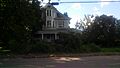
- Shumaker-Lewis House: Another historic home in Mason, recognized in 1979.
- Smithland Farm: This farm in Henderson was listed in 2003. Historic farms often show us how agriculture shaped the region.
Important Historic Districts and Sites
Sometimes, it's not just one building but a whole area that is historically important.
- Point Pleasant Battleground: This is a very important place in Point Pleasant, listed in 1970. It's where a famous battle took place long ago, which was a key event in American history. Today, it's a state park called Tu-Endie-Wei State Park.
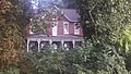
- Point Pleasant Historic District: This larger area in Point Pleasant, listed in 1985, includes many historic buildings along Main Street and Viand Street. Walking through this district is like taking a step back in time!
Images for kids
-
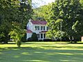
The historic Couch-Artrip House.
-
One of The Gold Houses in Mason.
-
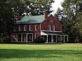
The Lewis-Capehart-Roseberry House.
-
The General John McCausland House.
-
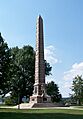
The monument at Point Pleasant Battleground.
-
An old mansion in the Point Pleasant Historic District.
-
The Powell-Redmond House.
-
The Shumaker-Lewis House.


