
National Register of Historic Places listings in Minnehaha County, South Dakota facts for kids

Hey there! Did you know that places can be super important because of their history? In Minnehaha County, South Dakota, there's a special list of buildings, areas, and other spots that are really old and cool. This list is called the National Register of Historic Places. It's like a hall of fame for historic sites across the United States!
These places are chosen because they tell important stories about the past. They might be old homes, schools, bridges, or even whole neighborhoods. When a place is on this list, it means people want to protect it so future generations can learn from it too.
In Minnehaha County, there are over 100 amazing places on this list! A few others used to be on it but have been removed for different reasons. Let's explore some of these cool historic spots!
Contents
Historic Buildings and Homes
Many of the places on the National Register are old buildings and houses. They show us how people lived and worked a long time ago.
Grand Old Houses
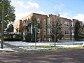
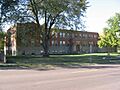
- All Saints School Main Building (Sioux Falls): This old school building at 101 W. 17th St. was added to the list in 1973. Imagine all the students who learned there!
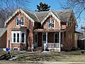
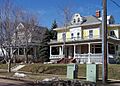
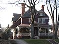
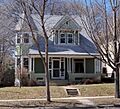
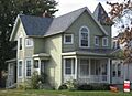
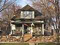
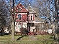
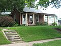
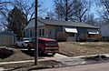
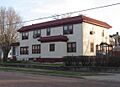
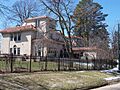
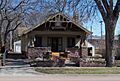
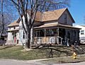
- Berdahl-Rolvaag House (Sioux Falls): Located at 1009 W. 33rd St., this house became historic in 1979. It's a peek into how homes looked back then.
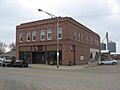
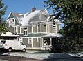
- Marion E. Bowen House (Sioux Falls): Found at 840 W. 9th St., this house joined the list in 1976. It's a great example of older homes in the city.
- Brooks Brothers Home (Sioux Falls): This interesting home at 1006-1008 South Dakota Ave. was added in 1996.
- Edward Coughran House (Sioux Falls): At 1203 S. 1st Ave., this house became historic in 1976.
- E.J. and Alice Daniels House (Sioux Falls): This home at 3901 S. Hawthorne was added in 1989.
- Harrison DeLong House (Sioux Falls): Located at 621 S. Main, this house joined the list in 2000.
- The Gloria House (Sioux Falls): This house at 1216 S. Center Ave. was added in 2000.
- Orlan A. Hayward House (Sioux Falls): At 1509 S. Glendale, this house became historic in 1998.
- Andrew O. Huseboe House (Sioux Falls): This home at 223 S. Prairie Ave. was added in 1988.
- Daniel Lund House (Sioux Falls): Located at 628 W. 20th, this house joined the list in 2000.
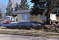
- William G. Milne House (Dell Rapids): This house at 508 E. 9th St. was added in 1994.
- Parmley-Pankow House (Sioux Falls): At 613 S. Main, this house became historic in 2004.
- Grant J. Reynolds House (Sioux Falls): This home at 800 S. Hawthorne St. was added in 1998.
- R.D. and Mary Springer House (Sioux Falls): Located at 201 W. 19th St., this house joined the list in 1995.
- Dr. Steven's House (Sioux Falls): This house at 21 S. Riverview Heights was added in 2002.
- Charles A. Thomas House (Sioux Falls): At 620 S. Dakota Ave., this house became historic in 1985.
- Laura M. Welch House (Sioux Falls): This home at 1218 S. Willow Ave. was added in 2000.
- Williams Piano Company House (Sioux Falls): Located at 1019 S. Norton, this house joined the list in 2000.
Important Buildings and Businesses
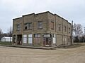
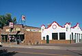
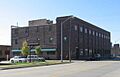
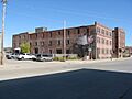
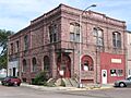
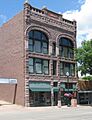
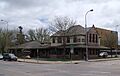
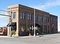
- Berg and Estensen Store (Sherman): This old store at 110 Zeliff Ave. was added to the list in 2001. It reminds us of how people used to shop.
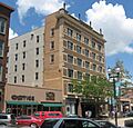
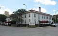
- Carpenter Hotel (Sioux Falls): Found at 221 S. Phillips Ave., this hotel became historic in 1986. Hotels like this were once very busy places!
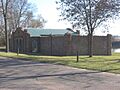
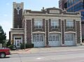
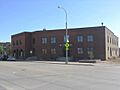
- Central Fire Station (Sioux Falls): This fire station at 100 S. Minnesota Ave. was added in 1980. It's cool to see where firefighters worked long ago.
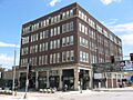
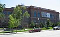
- Farley-Loetscher Company Building (Sioux Falls): This building at 701-705 E. 8th St. was added in 2001. Another building from the same company, Farley-Loetscher Company Building I, at 322 and 324 E. 8th St., joined in 2003.
- Federal Building and U.S. Courthouse (Sioux Falls): This important government building at 400 S. Phillips Ave. was added in 1974.
- First National Bank of Garretson (Garretson): This bank at 605 Main St. became historic in 2011. Banks are important for a town's growth.
- Grand Lodge and Library of the Ancient Free and Accepted Masons (Sioux Falls): This building at 415 S. Main Ave. was added in 1976.
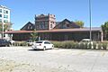
- Illinois Central Passenger Depot (Sioux Falls): This old train station near the Big Sioux River at 8th St. was added in 1983. Imagine all the people who traveled through here!
- Andrew Kuehn Warehouse (Sioux Falls): This warehouse at 401 N. Phillips Ave. became historic in 1982.
- L & A Baking Company (Sioux Falls): This bakery at 910 N. Main Ave. was added in 2007. Yum!
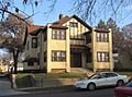
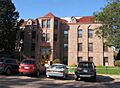
- LaSalle Apartments (Sioux Falls): These apartments at 703 S. Summit were added in 1998.
- L.D. Miller Funeral Home (Sioux Falls): This building at 507 S. Main Ave. was added in 1983.
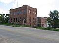
- John Mundt Building (Hartford): This building at 103 N. Main Ave. was added in 1981.
- Orpheum Theatre (Sioux Falls): This theater at 315 N. Phillips Ave. became historic in 1983. Think of all the shows and movies people watched here!
- R.F. Pettigrew and S.L. Tate Building (Sioux Falls): This building at 121-123 S. Main Ave. was added in 1986.
- Phillips Block (Sioux Falls): This building at 333-335 N. Main Ave. was added in 1978.
- Plumbing Supply Company (Sioux Falls): This building at 326 E. 8th St. became historic in 2005.
- Dr. Fredrich A. Randolph Block (Sioux Falls): This building at 320 N. Main was added in 1994.
- Rock Island Depot (Sioux Falls): Another old train station at 201 E. 10th St., added in 1974.
- Security Bank Building (Sioux Falls): This bank building at 101 S. Main Ave. was added in 1984.
- Shriver-Johnson Building (Sioux Falls): This building at 230 S. Phillips Ave. became historic in 1982.
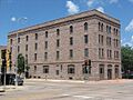
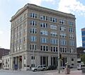
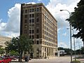
- Sioux Falls National Bank Building (Sioux Falls): This bank at 100 N. Phillips Ave. was added in 1979.
- Stock Yards State Bank and Tri-State Wholesale Grocery Co. (Sioux Falls): These buildings at 201/207/211 N. Weber Ave. were added in 2004.
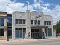
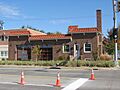
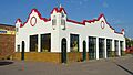
- Texaco Super Service Station (Sioux Falls): This old gas station at 330 S. 1st Avenue was added in 2013.
- John W. Tuthill Lumber Company (Sioux Falls): This lumber company building at 311 E. 8th St. was added in 2006.
Historic Districts and Areas
Sometimes, it's not just one building that's historic, but a whole group of them or an entire area! These are called "historic districts."
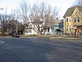
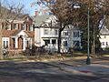
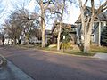
- All Saints Historic District (Sioux Falls): This area, roughly from Main to 2nd Ave. and 14th to 23rd Sts., became historic in 1984. It's a neighborhood with many old, important buildings.
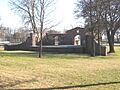
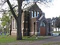
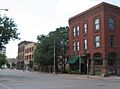
- Cathedral Historic District (Sioux Falls): This district, bounded by W. 4th and 10th Sts., Spring, Prairie, and Summit Aves., was added in 1974. It was once known as the Sioux Falls Historic District.
- Dell Rapids Historic District (Dell Rapids): This area at 335-536 E. 4th St. was added in 1978.
- Dell Rapids Residential Historic District (Dell Rapids): This neighborhood, roughly bounded by Orleans Ave., 4th St., and 7th St., became historic in 2000.
- Hayes Historic District (Sioux Falls): This area, roughly bounded by W. 22nd St. to W. 26th St. and by South Dakota Ave. to S. Phillips Ave., was added in 2006.
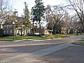
- McKennan Park Historic District (Sioux Falls): This district includes McKennan Park and surrounding streets, added in 1984.
- Old Courthouse and Warehouse Historic District (Sioux Falls): This area near the Big Sioux River, 4th and 6th Sts., and Dakota Ave., was added in 1983.
- Sherman Historic District (Sioux Falls): This district, roughly bounded by W. 18th St. to W. 22nd St., and S. Dakota Ave. to S. Main St., was added in 2004.
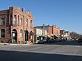
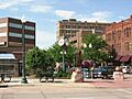
- Sioux Falls Downtown Historic District (Sioux Falls): This busy area, roughly bounded by S. Dakota and S. 1st Aves., W. 9th and W. 14th Sts., became historic in 1994.
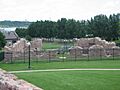
- Split Rock Creek Park Historic District (Garretson): This park area, about 1 mile north of Garretson, was added in 2000. It's a beautiful natural and historic spot.
Bridges, Parks, and Other Structures
Not all historic places are buildings! Some are bridges, parks, or other unique structures that played a role in the past.
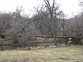
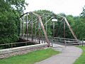
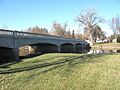
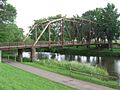
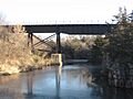
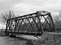
- Bridge at Iverson Crossing (Brandon): This bridge at 48054 266th St. was added in 1996. Bridges are important for travel and trade.
- Cherry Rock Park Bridge (Sioux Falls): This bridge in Cherry Rock Park was added in 2003.
- Dell Rapids Amphitheater (Dell Rapids): This outdoor stage in the city park was added in 2002. Imagine concerts and plays happening here long ago!
- Dell Rapids Bridge (Dell Rapids): There are two bridges with this name over the Big Sioux River that were added in 1999 and 2000.
- Dell Rapids Warming House (Dell Rapids): This warming hut on State Ave. was added in 2017. It was used by ice skaters on the Big Sioux River!
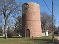
- Dell Rapids Water Tower (Dell Rapids): This water tower at 10th and Orleans was added in 1984. Water towers are vital for a town's water supply.
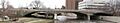
- Eighth Street Bridge (Sioux Falls): This bridge over the Big Sioux River was added in 1993.
- Old Yankton Bridge (Sioux Falls): This bridge on Old Yankton Rd. over the Big Sioux River was added in 1999.
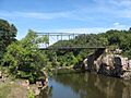
- Palisades Bridge (Garretson): This bridge at 25495 485th Ave. was added in 1999.
- Queen Bee Mill (Sioux Falls): This old mill at N. Weber Ave., Falls Park, was added in 1984. Mills were important for grinding grain.
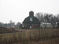
- Shafer Round Barn (Sioux Falls): This unique round barn at 1600 S. Powder House Rd. was added in 1995. Round barns are pretty rare!
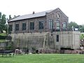
- Sioux Falls Light and Power Hydro Electric Plant (Sioux Falls): This power plant on the eastern bank of the Big Sioux River was added in 1993. It helped bring electricity to the area.
- Split Rock Park Bridge (Garretson): This bridge in Split Rock Park was added in 1993.
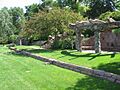
- Terrace Park and Japanese Gardens (Sioux Falls): This beautiful park at 1100 W. 4th St. was added in 2015.
- Valley Springs Rest Stop Tipi (Valley Springs vicinity): This cool sculpture of a tipi at Mi. 412.1 on I-90 West was added in 2015.
Schools, Churches, and Public Places
Many historic places are where people gathered for learning, worship, or community events.
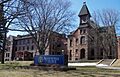
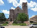
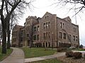
- Augustana College Historic Buildings (Sioux Falls): Buildings at 29th and S. Summit Sts. were added in 1977. Colleges have a long history of educating people.
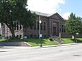
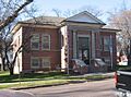
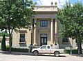
- Carnegie Free Public Library (Sioux Falls): This library at 235 W. 10th St. was added in 1973. Andrew Carnegie helped build many libraries across the country.
- Carnegie Public Library (Dell Rapids): Another Carnegie library at 513 N. Orleans, added in 1986.
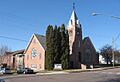
- First Congregational Church (Sioux Falls): This church at 303 S. Dakota Ave. was added in 1983. Churches are often central to a community's history.
- Josephine Martin Glidden Memorial Chapel (Sioux Falls): This chapel at 2121 E. 12th St. was added in 1987.
- Glidden-Martin Hall (Sioux Falls): This hall at 1101 W. 22nd Ave. was added in 2000.
- Jorden Hall (Sioux Falls): This hall at 1101 W. 22nd St. was added in 2000.
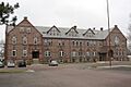
- Odd Fellows Home of Dell Rapids (Dell Rapids): This building at 100 W. 10th St. was added in 2012.
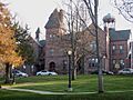
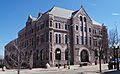
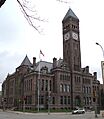
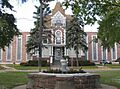
- Old Minnehaha County Courthouse (Sioux Falls): This important building at Main Ave. at 6th St. was added in 1973. Courthouses are where important decisions were made.
- Presentation Children's Home (Sioux Falls): This home at 701 S. Western Ave. was added in 1993.
- Renner Lutheran Sanctuary (Renner): This church west of South Dakota Highway 115 was added in 1980.
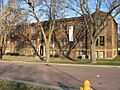
- South Dakota School for the Deaf (Sioux Falls): This school at 1800 E. 10th St. was added in 1981. It's important for its role in education.
- South Dakota State Penitentiary Historic Buildings (Sioux Falls): These buildings at 1600 North Dr. were added in 1978.
- South Side Fire Station No. 3 (Sioux Falls): This fire station at 1324 S. Minnesota Ave. was added in 1984.
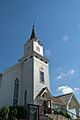
- St. Peter's Lutheran Church (Dell Rapids): This church at 701 North Orleans was added in 2002.
- Washington High School (Sioux Falls): This old high school building at 315 S. Main was added in 1986. It's now known as the Washington Pavilion of Arts and Science.
Farms and Rural Sites
Some historic places are out in the countryside, like old farms.
- Austin-Olson Farm (Colton): This farm at 24993 465th Ave. was added in 1995. Farms are a big part of South Dakota's history.
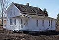
- Hans J. Hilmoe Barn (Baltic vicinity): This barn at 47170 Homestead St. was built in 1911 by Norwegian immigrants and added in 2010.
- Slip Up Creek Homestead (Garretson): This homestead at 25359 478th Ave. was added in 2003.
- Thompson Farmstead (Dell Rapids): This farm at 47339 248th St. was added in 1999.
- Tolefsons Beef Stock Farm (Colton): This farm at 24450 458th Ave. was added in 2002.
- Willow Grove Farm (Renner): This farm at 47480 258th Ave. was added in 2003.
Former Listings
Some places were once on the National Register but have been removed. This can happen if a building is changed too much, or if it's no longer there.
- Blackstone Court Apartments (Sioux Falls): This building was removed in 1988.
- South Dakota Department of Transportation Bridge No. 50-122-155 (Brandon Township): This bridge was removed in 2008.
- South Dakota Department of Transportation Bridge No. 50-192-132 (Renner): This bridge was removed in 2008.
- South Dakota Department of Transportation Bridge No. 50-200-035 (Dell Rapids vicinity): This bridge was removed in 1999.
- Summit Avenue Viaduct (Sioux Falls): This viaduct was removed in 2008.
These historic places help us remember the past and understand how Minnehaha County grew and changed over time!
Images for kids
-
All Saints Historic District
-
All Saints School Main Building
-
Augustana College Historic Buildings
-
Berdahl-Rolvaag House
-
Berg and Estensen Store
-
Marion E. Bowen House
-
Bridge at Iverson Crossing
-
Brooks Brothers Home
-
Building at 330 South 1st Avenue
-
Building at 529 North Main
-
Gina Smith Campbell Bathhouse
-
Carnegie Free Public Library (Sioux Falls)
-
Carnegie Public Library (Dell Rapids)
-
Carpenter Hotel
-
Cathedral Historic District
-
Central Fire Station
-
Cherry Rock Park Bridge
-
Edward Coughran House
-
E.J. and Alice Daniels House
-
Dell Rapids Amphitheater
-
Dell Rapids Bridge
-
Dell Rapids Historic District
-

Dell Rapids Residential Historic District
-
Dell Rapids Water Tower
-
Harrison DeLong House
-
Eighth Street Bridge
-
Farley-Loetscher Company Building
-
Farley-Loetscher Company Building I
-
Federal Building and U.S. Courthouse
-
First Congregational Church
-
Josephine Martin Glidden Memorial Chapel
-
Glidden-Martin Hall
-
The Gloria House
-
Grand Lodge and Library of the Ancient Free and Accepted Masons
-
Hayes Historic District
-
Orlan A. Hayward House
-
Andrew O. Huseboe House
-
Illinois Central Passenger Depot
-
Jorden Hall
-
Andrew Kuehn Warehouse
-
L & A Baking Company
-
LaSalle Apartments
-
Daniel Lund House
-
McKennan Park Historic District
-
L.D. Miller Funeral Home
-
William G. Milne House
-
John Mundt Building
-
Odd Fellows Home of Dell Rapids
-
Old Courthouse and Warehouse Historic District
-
Old Minnehaha County Courthouse
-
Old Yankton Bridge
-
Orpheum Theatre
-
Palisades Bridge
-
Parmley-Pankow House
-
R.F. Pettigrew and S.L. Tate Building
-
Phillips Block
-
Plumbing Supply Company
-
Presentation Children's Home
-
Queen Bee Mill
-
Dr. Fredrich A. Randolph Block
-
Renner Lutheran Sanctuary
-
Grant J. Reynolds House
-
Rock Island Depot
-
Security Bank Building
-
Shafer Round Barn
-
Sherman Historic District
-
Shriver-Johnson Building
-
Sioux Falls Downtown Historic District
-
Sioux Falls Light and Power Hydro Electric Plant
-
Sioux Falls National Bank Building
-
South Dakota School for the Deaf
-
South Dakota State Penitentiary Historic Buildings
-
South Side Fire Station No. 3
-
Split Rock Creek Park Historic District
-
Split Rock Park Bridge
-
R.D. and Mary Springer House
-
St. Peter's Lutheran Church
-
Dr. Steven's House
-
Stock Yards State Bank and Tri-State Wholesale Grocery Co.
-
Terrace Park and Japanese Gardens
-
Texaco Super Service Station
-
Charles A. Thomas House
-
John W. Tuthill Lumber Company
-

Valley Springs Rest Stop Tipi
-
Washington High School
-
Laura M. Welch House
-
Williams Piano Company House
-
South Dakota Department of Transportation Bridge No. 50-200-035 (former listing)


.jpg)
