
National Register of Historic Places listings in Morrow County, Ohio facts for kids

Welcome to Morrow County, Ohio! Did you know that some buildings and places here are super old and important? They are so special that they are listed on something called the National Register of Historic Places.
This list helps us remember and protect these amazing spots. It's like a special hall of fame for buildings, homes, and other places that have a lot of history. In Morrow County, there are 15 places currently on this list. One other place was once listed but has since been removed.
Contents
What is the National Register of Historic Places?
The National Register of Historic Places is the official list of the nation's historic places. It is part of a program by the United States government. This program helps to coordinate and support public and private efforts to identify, evaluate, and protect America's historic and archaeological resources.
When a place is added to this list, it means it's important to the history of the United States. It could be important because of its architecture, its connection to famous people, or events that happened there. Listing a place helps people know it's special and encourages its preservation.
Historic Places in Morrow County
Here are some of the cool historic places you can find in Morrow County, Ohio. Each one has a story to tell about the past!
Homes with History
Many old homes in Morrow County are on the list. These houses show us how people lived long ago.
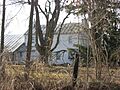
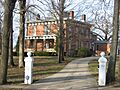
- Reuben Benedict House
This house is located west of Marengo, in Peru Township. It was added to the list on May 8, 2000. It's a great example of old architecture.
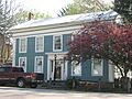
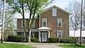
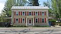
- Samuel P. Brown House
You can find this house south of Fulton, in Lincoln Township. It became a historic place on March 15, 1982.
- Jarvis House
Located at 77 S. Portland Street in Chesterville, this house joined the list on August 21, 1979.
- Enos Miles House
Also in Chesterville, at 154 S. Portland Street, this house was listed on August 21, 1979.
- A.B. Sears House
This home is at 52 W. Sandusky Street in Chesterville. It was recognized as historic on August 21, 1979.
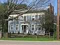
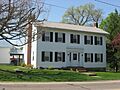
- James S. Trimble House
Found at 187 Iberia Street in Mount Gilead, this house was added to the list on November 30, 1982.
Important Public Buildings
Some buildings are important because they were used by the community or for government work.
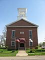
- Chester Town Hall
This building is at Sandusky and Short Streets in Chesterville. It was listed on August 21, 1979. Town halls are often places where important community decisions were made.
- Chesterville Methodist Church
Located at Sandusky and East Streets in Chesterville, this church was added to the list on August 21, 1979. Churches are often central to a community's history.
- Floral Hall
This unique building is at the Morrow County Fairgrounds in Mount Gilead. It became historic on December 12, 1976. Fairgrounds often have buildings that show local traditions.
- Levering Hall
You can find Levering Hall at 12 S. Main Street in Mount Gilead. It was listed on May 29, 1980.
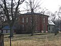
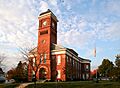
- Morrow County Courthouse and Jail
This important building is in Courthouse Square in Mount Gilead. It was recognized on July 25, 1974. Courthouses are where laws are made and justice is served.
- Old Union School
Located at 63 E. Denmon Avenue in Chesterville, this old school was listed on August 21, 1979. Schools are key to a community's growth and education.
- U.S. Post Office
The Post Office at 44 E. Sandusky Street in Chesterville was added to the list on August 21, 1979. Post offices were vital for communication in the past.
Historic Commercial Buildings
These buildings show us what businesses were like in the past.
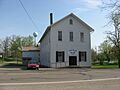
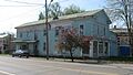
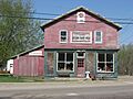
- Old Bartlett and Goble Store
This store is at Sandusky and Portland Streets in Chesterville. It was listed on August 21, 1979. Imagine what people bought here long ago!
- Wood Commercial Building
Also at Sandusky and Portland Streets in Chesterville, this building was recognized on August 21, 1979.
Former Listing
Sometimes, a place might be removed from the National Register. This can happen if the building is changed too much or is no longer standing.
- Exchange Hotel
The Exchange Hotel in Cardington was once listed on July 13, 1979. However, it was removed from the list on May 5, 1983.
Images for kids
-
The historic Reuben Benedict House.
-
The Samuel P. Brown House.
-
Chester Town Hall in Chesterville.
-
The Chesterville Methodist Church.
-
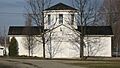
Floral Hall at the Morrow County Fairgrounds.
-
The Jarvis House in Chesterville.
-
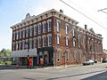
Levering Hall.
-
The Enos Miles House.
-
The Morrow County Courthouse and Jail.
-
The Old Bartlett and Goble Store.
-
The Old Union School in Chesterville.
-
The A.B. Sears House.
-
The James S. Trimble House.
-
The U.S. Post Office in Chesterville.
-
The Wood Commercial Building.


