
National Register of Historic Places listings in Nacogdoches County, Texas facts for kids

Nacogdoches County, located in East Texas, is a place rich in history! Many buildings and sites here are so important that they are listed on the National Register of Historic Places. This special list helps protect and celebrate places that tell us about the past. Think of it like a hall of fame for historic buildings and areas.
These places are important because they show us how people lived, worked, and built communities long ago. By learning about them, we can understand more about Texas history and the stories of the people who came before us.
Contents
- Discovering Nacogdoches' Historic Gems
- Historic Homes and Buildings
- Tol Barret House
- Blount Family Homes
- Durst-Taylor House
- Hoya Land Office Building
- Roland Jones House
- Old Cotton Exchange Building
- Old Nacogdoches University Building
- Old Post Office Building
- Roberts Building
- Southern Pacific Railroad Depot
- Sterne-Hoya House Museum and Library
- Woodmen of the World Building
- Historic Districts
- Unique Historic Sites
- Historic Homes and Buildings
- Images for kids
Discovering Nacogdoches' Historic Gems
Nacogdoches County is home to many fascinating historic sites. These places range from old homes where important people lived to buildings that were once busy centers of town life. Each one has a unique story to tell.
Historic Homes and Buildings
Many of the historic places in Nacogdoches County are old homes and buildings that have been around for a long time. They show us different styles of architecture and how people lived in the past.
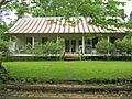
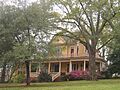
Tol Barret House
The Tol Barret House is one of these old homes. It was added to the National Register in 1979. It's located south of the city of Nacogdoches.
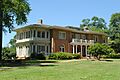
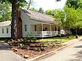
Blount Family Homes
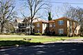
The Eugene H. Blount House and the Stephen William and Mary Price Blount House are two other important homes. The Eugene H. Blount House, built on North Street, was recognized in 1992. The Stephen William and Mary Price Blount House, on North Mound Street, was added to the list in 1991. These homes belonged to members of the Blount family, who were important in Nacogdoches.
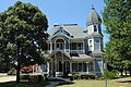
Durst-Taylor House
The Durst-Taylor House is another historic home, recognized in 2003. You can find it on North Street. This house gives us a peek into what homes looked like in the early 1800s.
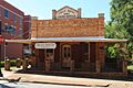
Hoya Land Office Building
The Hoya Land Office Building on East Pilar Street was added to the list in 1992. This building was once a place where land deals and important papers were handled.
Roland Jones House
The Roland Jones House on North Church Street is another historic residence. It was recognized in 1992.
Old Cotton Exchange Building
The Old Cotton Exchange Building on East Commerce Street became a historic place in 1992. This building was once a busy spot where cotton, a very important crop in Texas history, was traded.
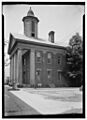
Old Nacogdoches University Building
The Old Nacogdoches University Building on Washington Square is a very special place. It was added to the National Register way back in 1971! This building was part of an early university in Texas.
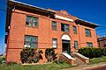
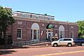
Old Post Office Building
The Old Post Office Building on East Main Street was recognized in 1992. Imagine all the letters and packages that passed through its doors over the years!
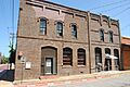
Roberts Building
The Roberts Building on East Pilar Street was also added to the list in 1992.
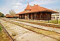
Southern Pacific Railroad Depot
The Southern Pacific Railroad Depot on West Main Street became a historic site in 1992. Train stations were once bustling hubs of travel and trade, connecting towns and cities.
Sterne-Hoya House Museum and Library
The Sterne-Hoya House Museum and Library on South Lanana Street was recognized in 1976. This house has a long history and now serves as a museum, helping people learn about the past.
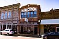
Woodmen of the World Building
The Woodmen of the World Building on East Main Street was added to the list in 1992. This building likely served as a meeting place for a fraternal organization.
Historic Districts
Sometimes, not just one building, but a whole group of buildings or an area is considered historic. These are called historic districts. They show how a neighborhood or downtown area looked and developed over time.
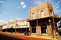
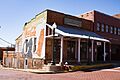
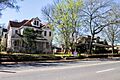
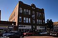
Nacogdoches Downtown Historic District
The Nacogdoches Downtown Historic District was recognized in 2008. This district includes many important buildings in the heart of Nacogdoches, showing its long history as a town center.
Sterne-Hoya Historic District
The Sterne-Hoya Historic District was added in 1992. This area includes the Sterne-Hoya House and other nearby streets, showing a historic neighborhood.
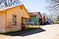
Virginia Avenue Historic District
The Virginia Avenue Historic District was recognized in 1992. This district includes parts of Bremond, Virginia Avenue, and Weaver streets.
Washington Square Historic District
The Washington Square Historic District was added to the list in 1992. This area is roughly bounded by Houston, Logansport, North Lanana, East Hospital, and North Fredonia streets.
Zion Hill Historic District
The Zion Hill Historic District was recognized in 1993. This district is roughly bounded by Park Street, Lanana Creek, Oak Grove Cemetery, and North Lanana Street.
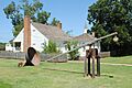
Unique Historic Sites
Not all historic places are buildings. Some are sites where important events happened or where unique discoveries were made.
Bernardo D'Ortolan Rancho Site and Raphael D'Ortolan Site
The Bernardo D'Ortolan Rancho Site and the Raphael D'Ortolan Site were both added to the National Register in 2014. These sites are important because they tell us about early ranches in the area. Their exact locations are kept private to protect them.
Oil Springs Oil Field Discovery Well
The Oil Springs Oil Field Discovery Well was recognized in 1977. This site, located southeast of Woden, is very important because it marks where oil was first discovered in Texas! This discovery changed the history of Texas and the United States.
Images for kids
-
Tol Barret House
-
Eugene H. Blount House
-

Stephen William and Mary Price Blount House
-
Maria A. Davidson Apartments
-
Durst-Taylor House
-
Hayter Office Building
-
Hoya Land Office Building
-
Roland Jones House
-
Nacogdoches Downtown Historic District
-
Old Cotton Exchange Building
-
Old Nacogdoches University Building
-
Old Post Office Building
-
Roberts Building
-
Southern Pacific Railroad Depot
-
Adolphus Sterne House (Sterne-Hoya House)
-
Sterne-Hoya Historic District
-
A house in the Virginia Avenue Historic District
-
Washington Square Historic District
-
Woodmen of the World Building
-
Zion Hill Historic District


.jpg)
.jpg)

.jpg)


.jpg)


.jpg)

.jpg)

.jpg)
