
National Register of Historic Places listings in Ogle County, Illinois facts for kids

Welcome to Ogle County, Illinois! This special place is home to many buildings, sites, and objects that are important to history. These places are so important that they have been added to the National Register of Historic Places. This is a list kept by the United States government to help protect and celebrate historic sites across the country.
In Ogle County, there are 27 different places on this list. Each one tells a unique story about the past, from old homes and schools to battlefields and famous statues. By learning about these sites, we can understand more about how people lived, worked, and shaped the world around them long ago.
Contents
What is the National Register of Historic Places?
The National Register of Historic Places is like a special club for buildings, structures, objects, sites, and districts that are important in American history, architecture, archaeology, engineering, or culture. When a place is added to this list, it means it is recognized for its value to our shared heritage. This helps to protect these places and makes people more aware of their importance.
Why are these places important?
These historic places are like time capsules. They show us what life was like in the past. They can teach us about different styles of buildings, how communities grew, and even about important events that happened right here in Ogle County. Protecting them means we can keep these stories alive for future generations.
Historic Homes in Ogle County
Ogle County has several beautiful old homes that are on the National Register. These houses often show us how people lived and what kind of architecture was popular many years ago.
The Bryant H. and Lucie Barber House
Located in Polo, the Bryant H. and Lucie Barber House was added to the list in 1993. It is a great example of a historic family home from the late 1800s.
The Henry D. Barber House
Also in Polo, the Henry D. Barber House joined the Register in 1974. This house belonged to another member of the Barber family, showing their importance in the community's early days.
The John Deere House and Shop
One of the most famous homes on the list is the John Deere House and Shop in Grand Detour. John Deere was a very important inventor who created the first successful steel plow. This invention changed farming forever! His house and shop were recognized in 1966 as a National Historic Landmark, which is an even higher level of historical importance.
Important Public Buildings and Sites
Many public buildings in Ogle County also have a rich history. These places were central to community life.
Buffalo Township Public Library
The Buffalo Township Public Library in Polo, listed in 1995, is a beautiful building that has served its community for many years. Libraries are important places for learning and gathering.
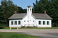
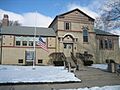
Chana School
The Chana School in Oregon, added in 2005, is a historic school building. It reminds us of how education used to be and the importance of schools in small towns.
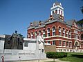
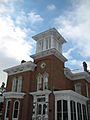
Ogle County Courthouse
The Ogle County Courthouse in Oregon, listed in 1981, is where many important decisions for the county have been made over the years. Courthouses are often grand buildings that stand as symbols of justice and local government.
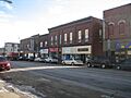
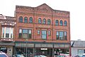
Oregon Commercial Historic District
The Oregon Commercial Historic District, added in 2006, isn't just one building but a whole area! It includes many historic shops and buildings in downtown Oregon. Walking through this district is like stepping back in time to see what the town looked like long ago.
Monuments and Battle Sites
Some places on the Register mark important events or honor special figures.
Black Hawk Statue
In Lowden Memorial State Park near Oregon, you can find the impressive Black Hawk Statue, listed in 2009. This large statue honors Native American history and culture in the area. It is a powerful reminder of the people who lived here before us.
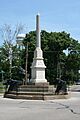
Soldier's Monument
The Soldier's Monument in Byron, added in 1985, honors soldiers who served our country. Monuments like this help us remember and respect the sacrifices made by brave individuals.
Stillman's Run Battle Site
The Stillman's Run Battle Site in Stillman Valley, listed in 1983, marks the location of an important battle during the Black Hawk War. This site helps us understand a significant conflict in Illinois history.
Other Unique Historic Places
Ogle County has a variety of other interesting historic sites.
Buffalo Grove Lime Kiln
The Buffalo Grove Lime Kiln near Polo, added in 2002, is an old structure used to make lime, a material important for building and farming. It shows us about early industries in the area.
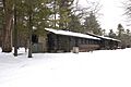
White Pines State Park Lodge and Cabins
The White Pines State Park Lodge and Cabins near Mount Morris, listed in 1985, offer a glimpse into early tourism and recreation. These buildings were designed to help people enjoy nature and relax.
Images for kids
-
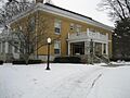
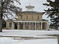
Bryant H. and Lucie Barber House
-
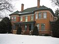
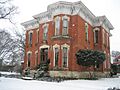
Henry D. Barber House
-
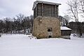
Buffalo Grove Lime Kiln
-
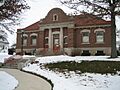
Buffalo Township Public Library
-
Chana School
-
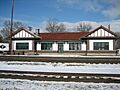
Chicago, Burlington, and Quincy Railroad Depot
-
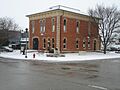
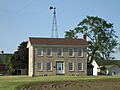
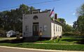
City and Town Hall
-
John Deere House and Shop
-

Flagg Township Public Library
-
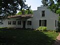
Samuel M. Hitt House
-
William H. Holcomb House
-
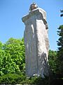
Indian Statue (Black Hawk Statue)
-
John McGrath House
-
William Moats Farm
-
Ogle County Courthouse
-
Oregon Commercial Historic District
-
Oregon Public Library
-
Pinehill Inn
-
Polo Independent Order of Odd Fellows Lodge No. 197
-
Soldier's Monument
-
Stillman's Run Battle Site
-
Village of Davis Junction Town Hall
-
White Pines State Park Lodge and Cabins


