
National Register of Historic Places listings in Ottawa County, Michigan
Ottawa County in Michigan is home to many amazing places that are part of the National Register of Historic Places. This special list includes buildings, sites, and objects that are important to the history of the United States. When a place is added to this list, it means it's recognized for its historical, architectural, archaeological, engineering, or cultural importance. It's like giving these places a special badge of honor!
These historic places in Ottawa County tell us stories about the past. They show us how people lived, worked, and built things long ago. Protecting these sites helps us remember and learn from history for many years to come.
Contents
Historic Homes and Buildings
Many of the places on the list are old homes and important buildings. These structures often show us the different styles of architecture from the past. They might have been owned by important people or played a big role in the community's development.
Grand Homes
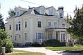
Some homes, like the Aloys Bilz House in Spring Lake or the Isaac Cappon House in Holland, are beautiful examples of older architecture. The Edward P. Ferry House in Grand Haven and the Egbert H. Gold Estate in Holland also stand out. These houses give us a peek into what life was like for families in the past. The Max and Esther De Pree House in Zeeland and the Lakewood Farm in Holland are more recent additions, showing different eras of design.
Community Cornerstones
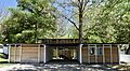
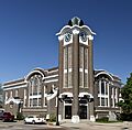
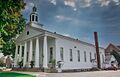
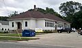
Other buildings served important roles in their towns. The Holland Old City Hall and Fire Station was once the center of local government and emergency services in Holland. Churches like the Holland Reformed Protestant Dutch Church (also known as the Pillar Church) and the Third Reformed Church of Holland have been central to their communities for a long time. Even old schools, like the Hudsonville Christian School Building and the Olive Township District No. 1 School, are recognized for their historical value.
Unique Structures and Districts
Ottawa County also has some very unique historic places, from a famous windmill to important transportation landmarks.
Iconic Windmill
One of the most famous landmarks is the De Zwaan Windmill in Holland. This real Dutch windmill was brought over from the Netherlands! It's a fantastic example of traditional Dutch engineering and a symbol of Holland's Dutch heritage. It helps us understand how windmills worked and how they were used in the past.
Bridges and Piers
Bridges are important for connecting places. The Fruitport Road–Pettys Bayou Bridge is a historic bridge that helped people travel across the water. Along the coast, the Piers and Revetments at Grand Haven, Michigan are also historic. These structures helped shape the harbor and protect the shoreline, making it safe for boats and ships.
Historic Districts
Sometimes, it's not just one building that's historic, but a whole area! These are called historic districts. The Grand Haven Historic District, Holland Downtown Historic District, Holland Historic District, and Ottawa Beach Historic District are all areas where many buildings together tell a story about how these towns grew and changed over time. Walking through these districts is like stepping back in time!
Transportation and Industry
Transportation has always been key to how communities grow. Ottawa County has several historic sites related to trains and shipping.
Railway History
The Grand Rapids, Grand Haven and Muskegon Railway Depot in Coopersville is an old train station. These depots were once busy hubs where people traveled and goods were shipped. The Grand Trunk Western Railroad Grand Haven Coal Tipple is another interesting site related to trains. It was used to load coal onto ships or other trains, showing how important coal was for energy and industry.
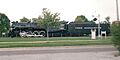
Perhaps one of the most exciting railway items is the Pere Marquette Railway Locomotive No. 1223 in Grand Haven. This old steam locomotive is a powerful reminder of the age of steam trains and how they moved people and goods across the country.
Lighthouse Guardian
Lighthouses have always been important guides for ships. The Holland Harbor Lighthouse, often called "Big Red," stands proudly at the mouth of Holland Harbor. It has guided countless ships safely into port, playing a vital role in the region's shipping history.
Ancient Sites
Long before towns and cities were built, people lived in Ottawa County. Some historic places are much older and tell us about ancient times.
Archaeological Discoveries
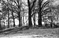
The Battle Point Site and the Spoonville Site in Crockery Township are archaeological sites. This means they are places where scientists study the remains of past human life and activities. These sites can reveal a lot about the Native American people who lived in this area thousands of years ago, showing us their tools, homes, and way of life.
Images for kids
-
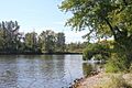
A view of the Battle Point Site area.
-
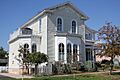
The historic Aloys Bilz House.
-

The Isaac Cappon House in Holland.
-
The Max and Esther De Pree House.
-
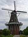
The famous De Zwaan Windmill in Holland.
-

The Edward P. Ferry House.
-

The Fruitport Road–Pettys Bayou Bridge.
-

The Egbert H. Gold Estate.
-
A church within the Grand Haven Historic District.
-
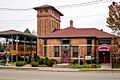
The old Coopersville Railroad Depot.
-
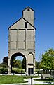
The Grand Trunk Western Railroad Grand Haven Coal Tipple.
-

A street view in the Holland Downtown Historic District.
-
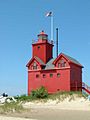
The Holland Harbor Lighthouse, also known as "Big Red."
-
A street in the Holland Historic District.
-

The former Holland City Hall and Fire Station.
-
The Holland Reformed Protestant Dutch Church (Pillar Church).
-
The historic Hudsonville Christian School building.
-
Lakewood Farm, a historic property.
-

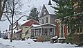
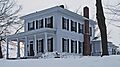
The Thomas and Anna Morrissey House.
-
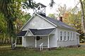
The Olive Township District No. 1 School.
-
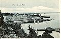
A historic postcard view of the Ottawa Beach Historic District.
-
The Pere Marquette Railway Locomotive No. 1223.
-
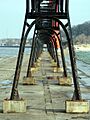
The historic Piers and Revetments at Grand Haven.
-
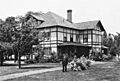
The Nathaniel and Esther (Savidge) Robbins House.
-
The Spoonville Site, an archaeological area.
-

The Third Reformed Church of Holland.
-
The Benjamin Van Raalte House.


