
National Register of Historic Places listings in Owen County, Kentucky facts for kids

Have you ever wondered about old buildings and places that tell a story? In Owen County, Kentucky, there are many special spots that are officially recognized for their history! These places are listed on something called the National Register of Historic Places. It's like a special list of important buildings, areas, and sites across the United States that are worth protecting and remembering.
This list helps everyone know which places in Owen County have a lot of history. It includes old homes, important buildings, and even whole neighborhoods that show us what life was like long ago. There are 17 different places in Owen County that are on this important list!
Contents
What is the National Register of Historic Places?
The National Register of Historic Places is America's official list of buildings, districts, sites, structures, and objects that are important in American history, architecture, archaeology, engineering, and culture. When a place is added to this list, it means it's considered very special and should be preserved for future generations.
Why are places added to the list?
Places get on the list for many reasons. Maybe a famous person lived there, or an important event happened there. Sometimes, a building is just a really great example of old architecture. Being on the list helps people understand the past and appreciate the unique character of their communities. It also encourages people to take care of these historic treasures.
Discovering Owen County's Historic Gems
Owen County is full of interesting places that have been around for a long time. Let's explore some of the types of places you might find on this special list.
Historic Homes and Buildings
Many of the places on the list are old houses or buildings that show us how people lived and worked in the past. These buildings often have unique designs and tell stories about the families who lived in them.
- Mason Brown House: This old house near Gratz is one of the historic homes on the list. It was added in 1998.
- L.O. Cox House: Located in Owenton, this house was recognized in 1984. It's a great example of the homes built in the area a long time ago.
- Ford House: Also in Owenton, this house on South Main Street is another historic spot from 1984.
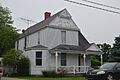
- Highfield: This building in Owenton, added in 1977, is a notable historic structure.
- Jacob Hunter House: Found near New Liberty, this house was listed in 1987. It's close to the Big South Fork of the Kentucky River.
- William Linsey House: This Owenton home from 1984 shows us more about the town's past.
- McKay House: Another Owenton house, listed in 1984, adds to the town's historic charm.
- Monterey Grade School: This old school building in Owenton, listed in 1997, reminds us of how kids learned in the past.
- Old Cedar Baptist Church: This church near Owenton, added in 1997, is an important part of the community's history and faith.
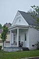
- E.E. Settle House: This Owenton house, listed in 1984, is another example of the historic homes in the area.
Important Public Buildings
Some buildings are important because they served the whole community.
- Owen County Courthouse and Jail:

Located in Owenton, this building is a very important part of the county's history. Courthouses are where local government happens and laws are made. This one was added to the list in 1976. It's a great example of public buildings from that time.
Historic Districts: Whole Neighborhoods with History
Sometimes, it's not just one building that's historic, but a whole group of buildings or a neighborhood. These are called "historic districts." They give us a picture of what a town looked like in the past.
- Byrns Landing: This historic district near Owenton was listed in 1997. It might have been an important place for boats or trade long ago.
- Central Owenton Historic District:

This large area in Owenton includes many streets like Bryan, Madison, Seminary, and Thomas. It was recognized in 1984. Walking through this district is like stepping back in time!
- Enos Hardin Farm: This farm near Owenton, listed in 1997, is a historic district that shows how farming was done in the past, especially near the Kentucky River.
- Monterey Historic District: This district in Monterey, added in 1997, includes streets like US Route 127, High, Hillcrest, and Taylor. It captures the historic feel of the town.
- New Liberty Historic District: This area in New Liberty, listed in 2001, covers parts of Kentucky Route 227. It's another great example of a historic neighborhood.
- North Main-North Adams Historic District:

This district in Owenton, recognized in 1984, includes North Main, North Adams, Bryan, and North Streets. It's another area where you can see many historic buildings together.
Images for kids
-
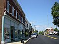
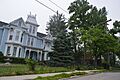
A view of downtown Owenton, part of its historic district.
-
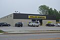
The Ford House, now a Dollar General store, in Owenton.
-
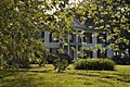
Highfield, a historic home in Owenton.
-
The William Linsey House in Owenton.
-
The McKay House in Owenton.
-
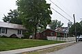
North Adams Street in Owenton, part of a historic district.
-
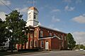
The historic Owen County Courthouse and Jail.
-
The site of the E.E. Settle House in Owenton.


