
National Register of Historic Places listings in Oxford County, Maine facts for kids

Welcome to Oxford County, Maine! This place is full of amazing history, and many of its special buildings and sites are protected. They are part of something called the National Register of Historic Places. Think of it like a special list of important places across the United States that are worth saving for future generations.
In Oxford County, there are about 100 different places on this list. These include old houses, bridges, churches, and even entire neighborhoods. Each one has a unique story to tell about the past. Let's explore some of these cool historic spots!
Contents
Exploring Oxford County's Historic Treasures
Oxford County is home to many buildings and areas that have been recognized for their historical importance. These places help us understand what life was like long ago and how communities grew.
Historic Homes and Buildings
Many of the listings are old homes or public buildings that show us how people lived and worked.
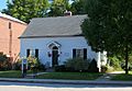
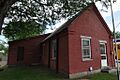
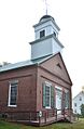
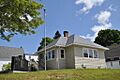
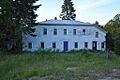
- The Albany Town House in Albany Township was built in 1856. It's a simple, classic building that served as a meeting place for the community.
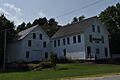
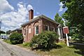
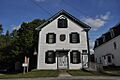
- In Andover, you can find the Andover Hook and Ladder Company Building, built in 1904. It was once where the fire department kept its equipment. The Andover Public Library (built in 1891) is another historic spot in Andover, where people have been borrowing books for over a century.
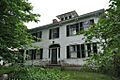
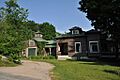
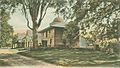
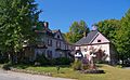
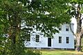
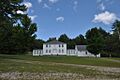
- The Barrows-Steadman Homestead in Fryeburg is a beautiful old house from the early 1800s. It shows us how homes were designed back then.
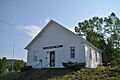
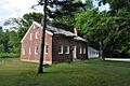
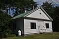
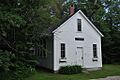
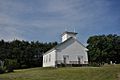
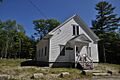
- In Otisfield, the Bell Hill Meetinghouse (built around 1830) and the nearby Bell Hill School (built around 1839) are great examples of early community buildings. They were central to life in the area.
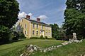
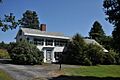
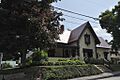
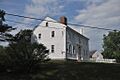
- The Nathaniel and Elizabeth Bennett House in Norway, built in 1803, is a well-preserved example of a Federal-style home.
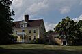
- The Brickett Place in Stow is a historic farmstead that dates back to the early 1800s. It gives us a peek into rural life.
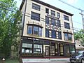
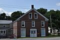
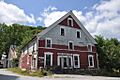
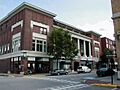
- In Bethel, the Cole Block (built 1897) is an important commercial building on Main Street. It shows how towns developed their downtown areas.
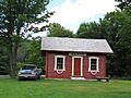
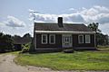
- The Deacon Hutchins House in Rumford, built in 1800, is one of the oldest homes in the area.
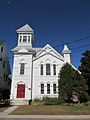
- The Deering Memorial United Methodist Church in Paris, built in 1911, is a grand church designed by famous architects.
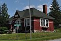
- The District No. 1 Schoolhouse in Fryeburg, built in 1839, was once a school and is now the local library. Imagine learning your ABCs there!
- Dreamhome in Woodstock, built in 1925, is a unique house located by Lake Christopher.
- The First Universalist Society of West Sumner (built 1845) is a historic church that has served its community for many years.
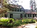
- Forest Lodge in Upton, built in 1908, is a rustic lodge that shows how people enjoyed nature in the past.
- The Foster Family Home in Newry, built around 1830, is a historic farm that tells the story of early settlers.
- The Fryeburg Registry of Deeds (built 1823) was where important land records were kept.
- The Former Fryeburg Town House (built 1848) was once the main government building for Fryeburg Center.
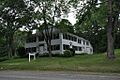
- The Gehring Clinic in Bethel, built in 1930, was a medical facility with a unique design.
- The Former Gilead Railroad Station (built 1907) was a busy train stop, important for travel and trade. It was even moved and brought back to Gilead!
- The Former Greenwood Town Hall (built 1895) in Locke Mills was the center of local government.
- The Hall House in Bethel, built in 1895, is a beautiful home that shows the architectural styles of its time.
- The Enoch Hall House in Buckfield, built in 1820, is another example of a well-preserved historic home.
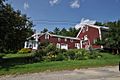
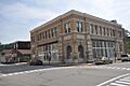
- The Hershey Plow Company Building in South Paris, built in 1890, was part of an important local industry.
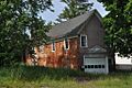
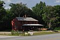
- The Hubbard-Cotton Store in Hiram, built around 1800, was a general store where people bought their goods.
- The Moses Hutchins House in Lovell, built in 1820, is a classic New England farmhouse.
- The J&O Irish Store in Hartford, built in 1820, is now a local history museum.
- The Zadoc Long Free Library in Buckfield, built in 1900, was designed by a famous architect, John Calvin Stevens.
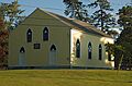
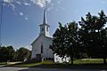
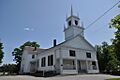
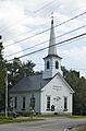
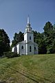
- The Lovell Meeting House (built 1794) and the Lovell Village Church (built 1851) are important community buildings in Lovell.
- The Lower Meeting House and East Bethel Cemetery (built 1829) in Bethel is a historic church and burial ground.
- The Lower Sunday River School in Newry, built in 1895, was a small schoolhouse.
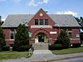
- The Arthur L. Mann Memorial Library in West Paris, built in 1899, is a beautiful library.
- The Dr. Moses Mason House in Bethel, built in 1813, is now a museum run by the Bethel Historical Society.
- The McLaughlin House and Garden in South Paris, built in 1890, is known for its lovely gardens.
- The McWain-Hall House in Waterford, built in 1800, is a historic farm.
- The Mechanic Institute in Rumford, built in 1911, was a place for learning and community events.
- The Merrill-Poor House in Andover, built in 1789, is one of the oldest homes in the area.
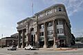
- The Municipal Building in Rumford, built in 1916, is the town's government center.
- The North Waterford Congregational Church (built 1829) is a lovely old church.
- The Nutting Homestead in Otisfield, built in 1790, is a very old farm.
- The Osgood Family House in Fryeburg, built in 1800, is another historic home.
- The Former Otisfield Town House (built 1845) was once the town's meeting place.
- The Paris Public Library in South Paris, built in 1908, was also designed by John Calvin Stevens.
- The Marion Parsons House in Fryeburg, built in 1800, is a historic residence.
- The Peabody Tavern in Gilead, built in 1807, was a popular stop for travelers.
- The John M. Philbrook House in Bethel, built in 1895, is now a charming inn.
- The Samuel D. Philbrook House in Bethel, built in 1895, is another historic home.
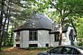
- The Porter Old Meetinghouse (built 1824) in Porter is a very old church.
- The E.C. and M.I. Record Homestead in Buckfield, built in 1800, is a historic farm.
- The Rivercroft Farm in Fryeburg, built in 1800, is a large historic farm.
- The Robinson-Parsons Farm in Paris, built in 1800, is another old farm.
- The Rumford Falls Power Company Building (built 1906) was important for providing power to the town.
- The Rumford Point Congregational Church (built 1865) is a beautiful church.
- The Rumford Public Library (built 1903) was designed by John Calvin Stevens.
- The Levi Sargent House in Otisfield, built in 1800, is a historic home.
- The Soldiers Memorial Library in Hiram, built in 1908, honors local soldiers.
- The Stearns Hill Farm in West Paris, built in 1800, is a historic farm.
- The Elisha F. Stone House in South Paris, built in 1830, is a unique Gothic-style home.
- The Strathglass Building in Rumford, built in 1906, is a historic commercial building.
- Sturtevant Hall at Hebron Academy in Hebron, built in 1891, was designed by John Calvin Stevens.
- The Union Church in Buckfield, built in 1833, is a historic church.
- The Former Upton Grange No. 404 (built 1906) was a meeting hall for a farming community group.
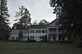
- Wadsworth Hall in Hiram, built in 1800, is a historic home.
- The David Warren House in Hartford, built in 1800, is another old house.
- The John Watson House in Hiram, built in 1800, is a historic farm.
- The West Paris Lodge No. 15, I.O.O.F. (built 1911) was a meeting hall for a fraternal organization.
- The Whitman Memorial Library in Woodstock, built in 1910, is a historic library.
- The Benjamin Wiley House in North Fryeburg, built in 1800, is a historic home.
Historic Bridges
Oxford County also has several historic bridges, which are important examples of early engineering.
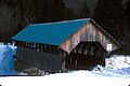
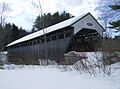
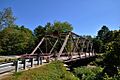
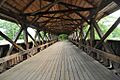
- The Bennett Bridge in Wilsons Mills, built in 1901, crosses the Magalloway River. It's a covered bridge, which means it has a roof and sides, protecting the wooden structure from the weather.
- The Churchill Bridge in Buckfield, built in 1907, crosses Bicknell Brook.
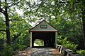
- The Hemlock Bridge in Fryeburg Center, built in 1857, crosses the Old Course Saco River. It's another beautiful covered bridge.
- The Lovejoy Bridge in South Andover, built in 1868, crosses the Ellis River. It's also a covered bridge, known for its charm.
- The Porter-Parsonfield Bridge in Porter, built in 1858, crosses the Ossipee River. This bridge connects Oxford County to York County.
- The Ryefield Bridge in Otisfield, built in 1889, crosses the Crooked River. It also extends into Cumberland County.
- The Sunday River Bridge in Newry, built in 1872, crosses the Sunday River. It's often called the "Artist's Bridge" because it's so picturesque.
Historic Districts
Sometimes, not just one building, but an entire area is considered historically important. These are called historic districts.
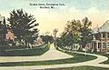
- The Broad Street Historic District in Bethel includes Broad Street and the Common, along with parts of Church and Park Streets. This area shows how the town center developed over time.
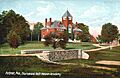
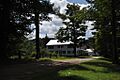
- The Center Meeting House and Common in Oxford, listed in 1997, is a historic gathering place.
- The Dreamhome in Woodstock, built in 1925, is a unique house located by Lake Christopher.
- The Eastman Hill Rural Historic District in Center Lovell is a scenic area with historic farms and homes.
- The Main Street Historic District in Fryeburg covers a significant part of the town's main street, showing its historical architecture.
- The Middle Intervale Meeting House and Common in Bethel, listed in 1998, is another important community area.
- The Norway Historic District includes a large part of downtown Norway, showing its development as a mill town.
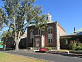
- The Oxford Congregational Church and Cemetery (listed 1994) is a historic church and burial ground.
- The Paris Hill Historic District in Paris Hill is a beautiful area with many old homes and buildings that show the town's early history.
- The Strathglass Park District in Rumford is a unique neighborhood designed for mill workers in the early 1900s. It's known for its planned layout and architecture.
- The Waterford Historic District includes parts of State Routes 35 and 37 in Waterford, showing the historic village center.
Archaeological Sites
Some listings are not buildings, but important archaeological sites that tell us about even older history, like Native American settlements.
- The Maine Archaeological Survey site 21.26 in Lovell is a protected site that helps us learn about early human activity in the area.
- The Rumford Falls I-IV Site, Rumford Falls V Site, and Town of Rumford Site in South Rumford are archaeological sites that provide clues about the past.
- The Vail Site in Parkertown Township is another important archaeological site.
Former Listing
Sometimes, a place is removed from the National Register of Historic Places. This can happen if it is significantly changed or destroyed.
- Knight's Country Store near Lovell was once on the list but was removed in 1987.
These historic places in Oxford County are like windows into the past, helping us understand the lives of people who came before us and how our communities were built.
Images for kids
-
Albany Town House
-
Andover Hook and Ladder Company Building
-
Andover Public Library
-
Barrows-Steadman Homestead
-

Bell Hill Meetinghouse
-
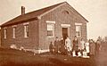
Bell Hill School
-
Bennett Bridge
-
Nathaniel and Elizabeth Bennett House
-
Brickett Place
-
Broad Street Historic District
-
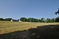
Center Meeting House and Common
-
Squire Chase House
-
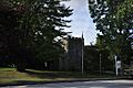
Church of the New Jerusalem
-
Churchill Bridge
-
Cole Block
-
Deacon Hutchins House
-

Deering Memorial United Methodist Church
-
District No. 1 Schoolhouse
-

Dreamhome
-
Eastman Hill Rural Historic District
-
First Universalist Society of West Sumner
-
Forest Lodge
-
Foster Family Home
-
Fryeburg Registry of Deeds
-
Fryeburg Town House, Former
-

Gehring Clinic
-
Gilead Railroad Station, Former
-
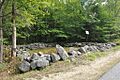
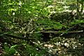
Greenwood Cattle Pound
-

Greenwood Town Hall, Former
-
Hall House
-
Enoch Hall House
-
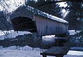
Hemlock Bridge
-
Hershey Plow Company Building
-
Hubbard-Cotton Store
-

Moses Hutchins House
-
J&O Irish Store
-
Zadoc Long Free Library
-
Lovejoy Bridge
-

Lovell Meeting House
-
Lovell Village Church
-

Lower Meeting House and East Bethel Cemetery
-
Lower Sunday River School
-
Main Street Historic District
-
Arthur L. Mann Memorial Library
-

Dr. Moses Mason House
-

McLaughlin House and Garden
-

McWain-Hall House
-
Mechanic Institute
-
Merrill-Poor House
-
Middle Intervale Meeting House and Common
-
Municipal Building
-

North Waterford Congregational Church
-

Norway Historic District
-
The Nutting Homestead
-
Osgood Family House
-
Otisfield Town House (Former)
-
Oxford Congregational Church and Cemetery
-
Paris Hill Historic District
-
Paris Public Library
-
Marion Parsons House
-
Peabody Tavern
-
John M. Philbrook House
-

Samuel D. Philbrook House
-

Porter Old Meetinghouse
-
Porter-Parsonfield Bridge
-
E.C. and M.I. Record Homestead
-
Rivercroft Farm
-
Robinson-Parsons Farm
-
Rumford Falls Power Company Building
-
Rumford Point Congregational Church
-
Rumford Public Library
-
Ryefield Bridge
-
Soldiers Memorial Library
-

Stearns Hill Farm
-
Elisha F. Stone House
-
Strathglass Building
-
Strathglass Park District
-
Sturtevant Hall
-
Sunday River Bridge
-
Union Church
-
Upton Grange No. 404 (Former)
-
Wadsworth Hall
-
David Warren House
-
Waterford Historic District
-
John Watson House
-
West Paris Lodge No. 15, I.O.O.F.
-
Whitman Memorial Library
-
Benjamin Wiley House


