
National Register of Historic Places listings in Pendleton County, Kentucky facts for kids

This article is about the special places in Pendleton County, Kentucky that are listed on the National Register of Historic Places. This list helps us protect important buildings and sites that tell us about the past.
The National Register of Historic Places is like a special club for buildings, areas, and objects that are important to American history. When a place is on this list, it means it's recognized for its historical or architectural value. This helps people understand why these places are special and encourages their protection.
In Pendleton County, Kentucky, there are 20 places currently on this list. One other place was on the list but has since been removed. You can even see where some of these places are on a map!
Contents
What is the National Register of Historic Places?
The National Register of Historic Places is the official list of the United States' historic places worth saving. It's part of a national program to coordinate and support public and private efforts to identify, evaluate, and protect America's historic and archaeological resources. Think of it as a way to make sure important parts of our history don't get lost.
Why are places listed?
Places are listed for many reasons. They might be very old, show a special style of building, or be connected to important people or events. For example, a house might be listed because a famous person lived there, or a church might be listed because it's a beautiful example of old architecture. Listing a place helps people know its story and encourages everyone to take care of it.
Historic Places in Pendleton County
Many of the historic places in Pendleton County are old homes and buildings, especially in the town of Falmouth, Kentucky. These places give us a peek into what life was like long ago.
Homes with History
Several houses in Pendleton County are on the National Register. Each one has its own story!
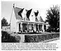
- Leslie T. Applegate House: Located at 410 Maple Street in Falmouth, this house was added to the list in 1983. It's a great example of the homes built in the area during its time.
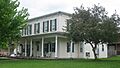
- Bishop House: You can find this house at 200 4th Street in Falmouth. It also joined the list in 1983, showing off the unique architecture of the past.
- Charity's House: At 108 Montjoy Street in Falmouth, this house was recognized in 1983. Even its name sounds interesting!
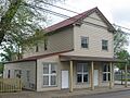
- Chipman House: This home at 901 Shelby Street in Falmouth was also listed in 1983. It's another example of the historic homes that make Falmouth special.
- House at 206 Park Street: This house in Falmouth, listed in 1983, is a reminder of the town's growth and development.
- Elzey Hughes House: Found at 308 2nd Street in Falmouth, this house was added to the list in 1983.
- George W. Jameson House: Located at 306 Park Street in Falmouth, this house joined the list in 1983.
- Kellum House: At 714 Shelby Street in Falmouth, this house was listed in 1983.
- McBride House: This house at 401 Main Street in Falmouth was also added in 1983.
- Pendleton House: Located at 506 W. Shelby Street in Falmouth, this house was listed in 1983.
- Frederick Reed House: You can find this house at 405 Broad Street in Falmouth. It was added to the list in 1983.
- Seaman Sisters' House: At 706 Shelby Street in Falmouth, this house was recognized in 1983.
- Sheehan House: This home at 206 N. Maple Street in Falmouth was listed in 1983.
- Southgate House: Located at 106 Montjoy Street in Falmouth, this house joined the list in 1983.
Other Important Structures
Not all listed places are houses! Some are unique buildings or even entire areas.
- Dolph Aluck Smokehouse: This interesting building on Milford Road near Falmouth was added to the list in 1987. A smokehouse was used long ago to preserve meat.
- Central Falmouth Historic District: This isn't just one building, but a whole area in Falmouth! It includes many streets like Shelby, 2nd, Montjoy, and Main Streets. It was listed in 1983 because many buildings in this area are historically important together.
- Henry Colvin House: This house on Colvin Bend Road near McKinneysburg, Kentucky was listed in 1987.
- Fryer House: Located northeast of Butler, Kentucky on U.S. Route 27, this house has been on the list since 1976.
- Immaculate Conception Catholic Church and Cemetery: This church and its cemetery on Stepstone Road in Peach Grove, Kentucky were listed in 1987. Churches often have beautiful architecture and long histories.
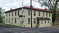
- Watson Store: This old store at 504 W. Shelby Street in Falmouth was added to the list in 1983. Stores like this were once very important centers for communities.
Former Listing
Sometimes, a place might be removed from the National Register. This usually happens if the building is changed too much, or if it is no longer standing.
- Oldham Plantation: This plantation near Falmouth on Kentucky Route 159 was listed in 1983 but was removed from the list in 2005.
Images for kids
-
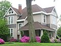
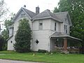
The Leslie T. Applegate House.
-
The historic Bishop House.
-
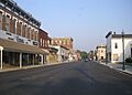
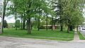
A view of Falmouth, part of the Central Falmouth Historic District.
-
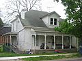
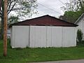
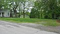
The site of Charity's House.
-
The Chipman House.
-
The house at 206 Park Street.
-
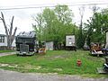
The site of the Elzey Hughes House.
-
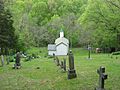
Immaculate Conception Catholic Church and its cemetery.
-
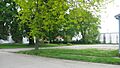
The site of the George W. Jameson House.
-
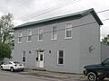
The Kellum House.
-
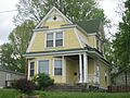
The McBride House.
-
The Pendleton House.
-
The site of the Frederick Reed House.
-
The site of the Seaman Sisters' House.
-
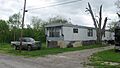
The site of the Sheehan House.
-
The site of the Southgate House.
-
The historic Watson Store.


