
National Register of Historic Places listings in Power County, Idaho facts for kids

Welcome to Power County, Idaho! This place is full of interesting history, and many of its special spots are listed on the National Register of Historic Places. Think of this register as a special list of buildings, areas, and objects across the United States that are important to our country's history. When a place is on this list, it means it's worth protecting and remembering for future generations.
In Power County, there are 12 different places that have made it onto this important list. These places tell stories about the past, from old buildings to natural landmarks. Let's explore some of them!
Contents
What is the National Register of Historic Places?
The National Register of Historic Places is like a hall of fame for historic sites in the United States. It's managed by the National Park Service. When a place is added, it means it has a special meaning in American history, architecture, archaeology, engineering, or culture. It helps people learn about and protect these important parts of our past.
Historic Buildings and Structures
Power County has several buildings that show us how people lived and worked long ago. These structures often have unique designs or played a big role in the community's development.
Power County Courthouse
The Power County Courthouse is a really important building in American Falls. It's where many local government decisions are made. Built in 1987, it's a key part of the city's history and how the county has grown over time. It's located at 543 Bannock Avenue.
Bethany Deaconess Hospital
The Bethany Deaconess Hospital, found at 500 Pocatello Highway Avenue, was added to the list in 1995. Hospitals are vital to a community's health and well-being, and this building likely served many people in the area for years.
Historic Homes
Several old homes in American Falls are also on the National Register. These houses give us a peek into the daily lives of families from the past.
- William Davie House: Located at 703 Hutchinson Avenue, this house was recognized in 2008.
- Walter Sparks House: You can find this home at 408 Roosevelt Street. It was added to the list in 2007.
- Richard and Winnie Warwas House: This house at 275 Polk Street was listed in 2006.
Each of these homes has its own story and unique style from when it was built.
St. John's Episcopal Church
Churches are often central to a community's history and culture. St. John's Episcopal Church, located at 328 Roosevelt Street, was added to the register in 2007. It represents the spiritual and community life of American Falls.
Important Historical Sites and Districts
Beyond individual buildings, some larger areas or specific natural spots in Power County are also recognized for their historical importance.
American Falls Archeological District
This district is a very special area where archaeologists study the remains of past human life. It helps us learn about the ancient people who lived in this region long before modern towns existed. Because of its sensitive nature, its exact address is restricted to protect the historical findings. It was listed in 1999.
American Falls East Shore Power Plants
These power plants, located along State Highway 39, were recognized in 1976. They are important because they show how electricity was generated in the past and how technology developed to power homes and businesses in the area.
American Falls Reservoir Flooded Townsite
The American Falls Reservoir is a large body of water, but underneath it lies the remains of an old townsite! When the reservoir was created, parts of the original town of American Falls were flooded. This site, listed in 2002, reminds us of how landscapes and communities can change over time.
Oneida Milling and Elevator Company Grain Elevator
This grain elevator is offshore in the American Falls Reservoir. Listed in 1993, it's a reminder of the area's agricultural past. Grain elevators were crucial for storing and moving crops, showing the importance of farming to the local economy.
Oregon Trail Historic District
The Oregon Trail was a famous route pioneers took to travel west in the 1800s. This historic district, southwest and west of American Falls along U.S. Route 30N, marks a part of that famous journey. It was listed in 1973 and helps us remember the brave people who traveled across the country.
Register Rock
West of American Falls on U.S. Route 30, you'll find Register Rock. This natural landmark was a significant stop for pioneers on the Oregon Trail. Many travelers carved their names, dates, and messages into the rock as they passed by. It's like a giant guestbook from the past, showing us the actual marks left by people who lived long ago. It was added to the register in 1978.
Images for kids
-

An image representing a restricted address.
-
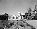
The East Shore Power Plant in American Falls.
-
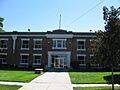
The Power County Courthouse.
-
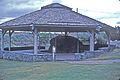
Register Rock, a historic landmark.


