
National Register of Historic Places listings in Putnam County, Florida facts for kids

Welcome to Putnam County, Florida! Did you know that many special buildings and places here are protected because of their history? They are listed on something called the National Register of Historic Places. This list helps us remember and take care of important parts of our past.
In Putnam County, there are 19 different places and areas that are on this special list. These include old churches, schools, homes, and even entire neighborhoods! Each one has a unique story to tell about what life was like long ago in Florida. Let's explore some of these amazing historic spots!
Contents
- Exploring Historic Places in Putnam County
- Bethel African American Episcopal Church
- Bostwick School
- Bronson-Mulholland House
- Central Academy
- Crescent City Historic District
- Cummings House
- Hubbard House
- Interlachen Hall
- Larimer Memorial Library
- Melrose Historic District
- Melrose Woman's Club
- Mount Royal
- Old A.C.L. Union Depot
- Palatka North Historic District
- Palatka Ravine Gardens Historic District
- Palatka South Historic District
- St. Marks Episcopal Church
- Tenney House and Groveland Hotel
- Images for kids
Exploring Historic Places in Putnam County
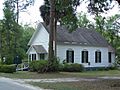
Bethel African American Episcopal Church
The Bethel African American Episcopal Church is located at 719 Reid Street in Palatka. This church was added to the National Register on May 16, 2016. It's an important place that shows the history of the African American community in the area.
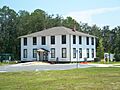
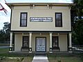
Bostwick School
The Bostwick School, found at 125 Tillman Street in Bostwick, became a historic site on September 29, 1999. Schools like this one are often important because they show how education has changed over time.
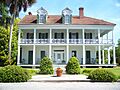
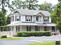
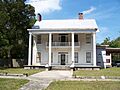
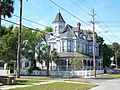
Bronson-Mulholland House
In Palatka, you can find the Bronson-Mulholland House on Madison Street, between 1st and 2nd Streets. This historic home was added to the list on December 27, 1972. Old houses like this give us a peek into how people lived many years ago.
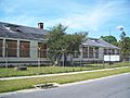
Central Academy
Central Academy, located at 1207 Washington Street in Palatka, joined the National Register on November 12, 1998. It's another important educational building that tells a story about the community's past.
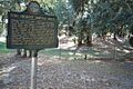
Crescent City Historic District
A "Historic District" means a whole area or neighborhood is special. The Crescent City Historic District is roughly bordered by Lake Stella, Vernon Avenue, Lake Crescent, and Orange Avenue in Crescent City. It was recognized on December 5, 1996. Walking through a historic district is like stepping back in time!
Cummings House
The Cummings House in Palatka is at 298 County Road 310. It was listed on March 17, 2015. This house is on private property, so it's not usually open for visitors.
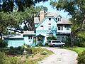
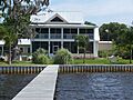
Hubbard House
In Crescent City, the Hubbard House is located at 600 North Park Street, inside Hubbard Park. It became a historic site on August 14, 1973. It's great when historic homes are part of public parks!
Interlachen Hall
Interlachen Hall, at 215 Atlantic Avenue in Interlachen, was added to the list on June 2, 2000. Community halls like this were often central places for people to gather for events and meetings.
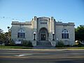
Larimer Memorial Library
The Larimer Memorial Library is at 216 Reid Street in Palatka. It was recognized on March 12, 2008. Libraries are special places that hold knowledge and history, and this one is a historic building itself!
Melrose Historic District
Another historic district is the Melrose Historic District in Melrose. It's generally bounded by Seminole Ridge Road, Grove Street, South Street, Quail Street, and Melrose Bay. This area was listed on January 12, 1990.
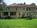
Melrose Woman's Club
The Melrose Woman's Club, on Pine Street in Melrose, joined the National Register on April 6, 1978. Woman's Clubs often played a big role in community development and social activities.
Mount Royal
Mount Royal, located near Welaka, was listed on May 7, 1973. The exact address is restricted, meaning it's not publicly shared, often to protect the site.
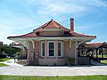
Old A.C.L. Union Depot
The Old A.C.L. Union Depot, also known as the Palatka Amtrak station, is at 200 North Twelfth Street in Palatka. This old train station was added to the list on February 25, 1988. Train stations are important because they show how people and goods traveled in the past.
Palatka North Historic District
The Palatka North Historic District is a large area in Palatka, roughly bordered by the St. Johns River and Bronson, North 1st, North 5th, and Main Streets. It was recognized on November 17, 1983.
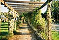
Palatka Ravine Gardens Historic District
Ravine Gardens State Park is also a historic district! It's located at 1600 Twigg Street in Palatka and was listed on June 10, 1999. This park is known for its beautiful, unique landscape.
Palatka South Historic District
Another historic district in Palatka is the Palatka South Historic District. It's generally bounded by the St. Johns River and Oak, South 9th, and Morris Streets. This area was also listed on November 17, 1983, along with the North Historic District.
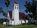
St. Marks Episcopal Church
St. Marks Episcopal Church is at 2nd and Main Streets in Palatka. This beautiful church was added to the National Register on May 9, 1973. Churches often have long histories and beautiful architecture.
Tenney House and Groveland Hotel
The Tenney House and Groveland Hotel are located at 100 and 102 Commercial Avenue in Federal Point. These buildings were listed on October 30, 1997. Hotels and houses from the past can tell us a lot about how people lived and traveled.
Images for kids
-

Bethel African American Episcopal Church
-
Bostwick School
-
Bronson-Mulholland House
-
Central Academy
-
Crescent City Historic District
-
Hubbard House
-
Interlachen Hall
-
Larimer Memorial Library
-
Melrose Historic District
-
Melrose Woman's Club
-
Mount Royal
-
Old A.C.L. Union Depot
-
Palatka North Historic District
-
Palatka Ravine Gardens Historic District
-
Palatka South Historic District
-
St. Marks Episcopal Church
-
Tenney House and Groveland Hotel


