
National Register of Historic Places listings in Putnam County, New York facts for kids

Welcome to Putnam County, New York! This area is full of amazing old buildings and places that are super important to history. These special spots are listed on the National Register of Historic Places. Think of it like a Hall of Fame for buildings and areas!
When a place is on this list, it means it's recognized by the United States government for its historical or architectural value. It helps protect these places for future generations to enjoy. In Putnam County, we have many cool places, from grand old homes to historic churches and even parts of old roads. Let's explore some of them!
Contents
Historic Homes and Estates
Putnam County is home to many beautiful and historic houses, each with its own story.
Boscobel: A Grand Old Home

Imagine a fancy house built over 200 years ago! That's Boscobel, a stunning example of a Federal style mansion. It was built by States Dyckman in 1808. What's super cool is that this house was actually moved from its original spot in Montrose! It was carefully taken apart and rebuilt here to save it when a hospital was being built. Now, you can visit it and see many of its original furnishings.
Castle Rock: A Mountaintop Mansion

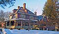
High up on a mountain in Garrison, you'll find Castle Rock. This amazing estate was built in 1881 for William Osborn, who was a big boss at the Illinois Central railroad. It's known for its unique and mixed architectural styles, making it a real landmark in the Hudson Highlands area.
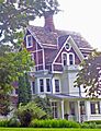
The Birches: A Victorian Gem

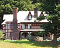
Also in Garrison, The Birches is a beautiful house built in 1882. It's designed in the Victorian Gothic style, which means it has lots of decorative details and pointed arches, like a mini-castle! It was designed for William Osborn, the same railroad president who owned Castle Rock. His sons even used it as their honeymoon house!
Walter Brewster House: A Greek Revival Beauty

In the town of Brewster, you can find the Walter Brewster House. Walter Brewster was the person who founded the village! This house is special because it's the only Greek Revival home in Putnam County with a two-story colonnade. A colonnade is a row of tall columns, just like you might see on ancient Greek temples.
Eagle's Rest: A Yankee's Retreat

This grand estate in Philipstown was once the home of Jacob Ruppert, who owned the famous New York Yankees baseball team! Today, it's known as Saint Basil Academy.
Manitoga: A Home Blending with Nature

Manitoga is a truly special place. It was the estate of Russel Wright, a famous industrial designer from the 1900s. He designed his house to be super sustainable and to blend right into the landscape around it. This was one of the very first homes in America to be built this way! It's so important that it's even a National Historic Landmark, the only one in Putnam County.
Rock Lawn: Another Upjohn Masterpiece

Rock Lawn, built in 1853, is another house designed by the famous architect Richard Upjohn. It's his only Italian Villa-style house in the Hudson Highlands. Imagine living in a house that looks like it came straight from Italy! A famous politician, Hamilton Fish II, lived here in the late 1800s.
Important Public Buildings
Beyond homes, Putnam County also has historic buildings that served the community.
Putnam County Courthouse: A Landmark of Justice

The Putnam County Courthouse in Carmel was built way back in 1814. It's still used for some court offices today! This makes it the second-oldest county courthouse in New York State that is still in use. That's a lot of history happening within its walls!
Reed Memorial Library: A Place for Books

Also in Carmel, the Reed Memorial Library is a beautiful stone building. It was built to honor a local construction leader. It's the oldest library building in Putnam County, a true treasure for book lovers!
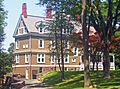
First National Bank of Brewster: A Queen Anne Style Bank

This building in Brewster, from the late 1800s, is a great example of Queen Anne style architecture. It has lots of different textures, shapes, and decorative details. It used to be a bank, then the town hall, and some town offices are still there today!
Old Southeast Town Hall: A Community Hub

The Old Southeast Town Hall in Brewster is an early but well-designed building. It has a Colonial Revival style, which means it looks back to older American styles, but it also has some unique Moorish Revival touches. It even had a theater upstairs! Today, it's still used by the town and for community events.
Historic Districts and Areas
Some places are important not just for one building, but for a whole group of buildings or an entire area. These are called historic districts.
Cold Spring Historic District: A Riverside Town

The Cold Spring Historic District includes the main parts of this charming riverside town. It's really well-preserved, showing what a town looked like in the late 1800s. Walking through it is like taking a step back in time!
Garrison Landing Historic District: A Filming Location!

This district is right by the Hudson River and the train tracks in Garrison. It was a busy commercial area in the mid-1800s. Fun fact: it was even used as a filming location for the 1969 movie Hello, Dolly!
Indian Brook Road Historic District: A Rural Hamlet

This district in Garrison was once a small rural village called Nelson's Corner. It's special because it's one of the few old villages that still looks much like it did before big industries came along. Its original layout and buildings are still mostly there.
Old Albany Post Road: A Very Old Road

Imagine driving on a road that's been around since the mid-1600s! The Old Albany Post Road in Philipstown is an unpaved section of the original road that connected New York City to Albany. It even has its original mile markers. It's one of the oldest dirt roads still in use in the entire United States!
West Point Foundry: Makers of Cannons

The West Point Foundry in Cold Spring was a super important place in the 1800s. They made cannons for the U.S. Army! This foundry was a big reason why Cold Spring and Nelsonville grew so much. The site is now recognized as a historic district and an archaeological site, meaning experts study what's left there to learn more about its past.
Churches and Cemeteries
These places offer a look into the spiritual and community life of early Putnam County.
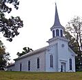
First Baptist Church of Cold Spring: Oldest in Philipstown

Built in 1833, this church in Nelsonville is the oldest church building in the town of Philipstown. It's also the only frame (wooden) church in the Hudson Highlands area.
Gilead Cemetery: Graves and Art

This cemetery in Carmel has graves dating back to the mid-1700s! You can find the resting place of Enoch Crosby, a spy from the American Revolutionary War, here. It also has a really large collection of funerary art, which means the gravestones and monuments themselves are like works of art, showing how people's ideas about death changed over time.
St. Philip's Church in the Highlands: Washington's Intervention?

This beautiful church in Garrison was designed by Richard Upjohn in 1850. The church congregation has been around since the 1760s! There's a story that the earlier church building on this site was saved from an angry mob during the Revolution because George Washington himself stepped in to protect it.
St. Andrew's Episcopal Church: A Stone Church

Built in 1903, this Gothic Revival church in Brewster was made possible by a generous donation. It's special because it's the only stone church in eastern Putnam County.
Tompkins Corners United Methodist Church: An Unusual Shape

This church in Putnam Valley, built in 1891, has an unusual L-shape. This is because it was built on the old church's foundation (the base of the building). It serves one of the oldest Methodist groups in the area.
Other Notable Places
There are many other interesting places on the National Register in Putnam County.
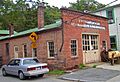
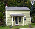
H. D. Champlin & Son Horseshoeing and Wagonmaking

This building in Nelsonville was once a shop where horses were shod and wagons were made in the late 1800s. It's still almost exactly as it was back then!
Cold Spring Cemetery Gatehouse

This gatehouse, built in 1862, has a very unusual roof style. It's one of the earliest examples of the Gothic Revival style in the Hudson Highlands.
Fish and Fur Club: Now Village Hall

This rustic clubhouse, built in 1905, was originally for sportsmen who enjoyed fishing and hunting. Today, it serves as the Nelsonville Village Hall!
Taconic State Parkway: A Scenic Road

The Taconic State Parkway is a beautiful, scenic highway that runs through Putnam County. It was planned by President Franklin D. Roosevelt himself! Built between the 1920s and 1960s, it's a great example of how parkways were designed to be beautiful and connect people to state parks.
Images for kids
-
The old H. D. Champlin & Son shop.
-
The unique Cold Spring Cemetery Gatehouse.
-
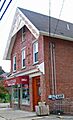
The ornate J. Y. Dykman Flour and Feed Store.
-
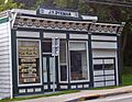
The J. Y. Dykman Store, now an antique map shop.
-
The First Baptist Church of Cold Spring.
-
The Fish and Fur Club, now Nelsonville Village Hall.
-
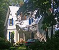
A house in Nelsonville with Italianate and Carpenter Gothic styles.
-
An Italianate brick residence in Nelsonville.
-
A well-preserved foundry worker's house.
-
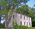
The Mandeville House, the oldest house in Garrison.
-
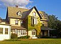
Montrest, a summer home from 1868.
-
The Norman-style gatehouse of Normandy Grange.
-
The Old Southeast Church, built in 1794.
-
Plumbush, home of the inventor of the Parrott gun.
-
The Walter Thompson House and Carriage House.
-
The Walker House, given by a rail magnate to his daughter.
-
The Wilson House, with fine Carpenter Gothic details.
-
Woodlawn, an estate house now home to the Hastings Center.


