
National Register of Historic Places listings in Ridgewood, New Jersey facts for kids

Ridgewood is a lovely village in Bergen County, New Jersey. It's a place with a rich history, and many of its old buildings and areas are so special that they are listed on the National Register of Historic Places. This means they are officially recognized as important parts of American history and culture.
These historic places help us learn about how people lived long ago. They show us the architecture, daily life, and important events that shaped Ridgewood. Let's explore some of these amazing sites!
Exploring Ridgewood's Historic Homes
Many of Ridgewood's historic listings are old homes, often named after the families who built or lived in them. These houses give us a peek into the past.
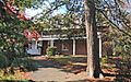
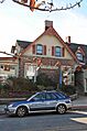
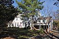
Ackerman House (222 Doremus Avenue)
This historic home, located at 222 Doremus Avenue, was added to the National Register of Historic Places on January 10, 1983. It's one of several Ackerman family homes recognized for their historical value.
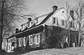
Ackerman House (252 Lincoln Avenue)
Another Ackerman House, this one at 252 Lincoln Avenue, also became a historic site on January 10, 1983. These homes often show the traditional building styles of the area from many years ago.
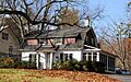
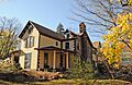
David Ackerman House
The David Ackerman House, found at 415 East Saddle River, is another important building from the Ackerman family's history. It was listed on January 10, 1983, preserving its unique character.
Ackerman-Van Emburgh House
This house, located at 789 East Glen Avenue, combines the history of two families: Ackerman and Van Emburgh. It was recognized as a historic place on January 10, 1983, showing how families shaped the community.
Archibald-Vroom House
The Archibald-Vroom House at 160 East Ridgewood Avenue was added to the National Register on July 24, 1984. It stands as a reminder of the people and architecture from its time.
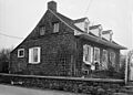
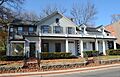
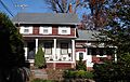
Rathbone-Zabriskie House
Located at 570 North Maple Avenue, the Rathbone-Zabriskie House became a historic site on January 10, 1983. It's another example of the beautiful and important homes in Ridgewood's past.
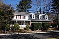
Van Dien House
The Van Dien House, found at 627 Grove Street, was listed on January 10, 1983. This house helps tell the story of the families who lived and worked in Ridgewood.
Vanderbeck House
At 249 Prospect Street, the Vanderbeck House was added to the National Register on January 10, 1983. It contributes to the rich collection of historic homes in the village.
Westervelt-Cameron House
The Westervelt-Cameron House, located at 26 East Glen Avenue, was recognized as a historic place on January 10, 1983. It's a significant part of Ridgewood's architectural heritage.
Albert J. Zabriskie Farmhouse
This farmhouse, located at 7 East Ridgewood Avenue, is an important historic site. It was added to the National Register on November 7, 1977. While sometimes linked to Ridgewood, it is actually in nearby Paramus, New Jersey.
Other Important Historic Sites
Besides homes, Ridgewood also has other types of buildings and areas that are important to its history.
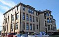
Beech Street School
The Beech Street School, located at 49 Cottage Place, is a historic school building. It was listed on March 12, 1998, showing its importance to education and the community's growth.
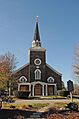
Paramus Reformed Church Historic District
This historic district is a special area that includes the Paramus Reformed Church and its surroundings. It's bounded by Franklin Turnpike, Route 17, Saddle River, the south side of the cemetery, and Glen Avenue. This district was recognized on February 25, 1975, because it represents an important part of the area's religious and community history.
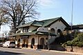
Ridgewood Station
The Ridgewood Station, found at Garber Square, is a historic train station. It was added to the National Register on June 22, 1984. Train stations were very important for travel and trade in the past, connecting communities.
Images for kids
-
Ackerman House (222 Doremus Avenue)
-
Ackerman House (252 Lincoln Avenue)
-
David Ackerman House
-
Ackerman-Van Emburgh House
-
Archibald-Vroom House
-
Beech Street School
-
Paramus Reformed Church Historic District
-
Rathbone-Zabriskie House
-
Ridgewood Station
-
Van Dien House
-
Vanderbeck House
-
Westervelt-Cameron House
-
Albert J. Zabriskie Farmhouse


