
National Register of Historic Places listings in San Juan County, Colorado facts for kids

Welcome to San Juan County, Colorado! This area is full of amazing history, especially from the time when mining was a huge deal. Many places here are so important that they've been added to a special list called the National Register of Historic Places. This list is like a hall of fame for buildings, sites, and objects that have played a big part in American history.
In San Juan County, there are 12 different places that have earned a spot on this list. These historic sites help us remember the past and understand how people lived and worked long ago. They tell stories of brave miners, busy railroads, and the growth of towns in the rugged mountains of Colorado. Let's explore some of these cool historic spots!
Contents
- Exploring San Juan County's Historic Places
- Animas Forks: A Ghost Town's Story
- Cascade Boy Scout Camp: An Outdoor Adventure Spot
- Durango and Silverton Narrow Gauge Railroad: A Journey Through History
- Gold Prince Mine, Mill and Aerial Tramway: Mining Marvels
- Martin Mining Complex: A Miner's Life
- Minnie Gulch Cabins: Homes in the Wild
- Placer Gulch Boarding House: Community Life
- Shenandoah-Dives (Mayflower) Mill: Processing the Riches
- Silverton Historic District: A Town Frozen in Time
- Sound Democrat Mill and Mine and Silver Queen Mine: Twin Treasures
- Tobasco Mine and Mill: A Cross-County Connection
- Images for kids
Exploring San Juan County's Historic Places
San Juan County is home to many fascinating places that are protected because of their historical importance. Most of these sites are connected to the exciting, and sometimes tough, history of mining in Colorado.
Animas Forks: A Ghost Town's Story
Animas Forks is a famous ghost town located high in the mountains near Silverton. It was once a busy mining community, full of people hoping to strike it rich by finding gold and silver. Today, you can still see the old buildings, like homes and a mill, standing as silent reminders of a time when this area was bustling with activity. It's like stepping back in time to see how miners and their families lived in such a remote and challenging environment.
Cascade Boy Scout Camp: An Outdoor Adventure Spot
The Cascade Boy Scout Camp is a historic place that shows how people used the beautiful natural areas for recreation and learning. Located near Durango, this camp has been a special spot for Boy Scouts for many years. It's a great example of how outdoor spaces can be used for education and adventure, connecting young people with nature and teaching them important skills.
Durango and Silverton Narrow Gauge Railroad: A Journey Through History
One of the most famous historic sites in the area is the Durango and Silverton Narrow Gauge Railroad. This amazing train line has been running since 1882! It was originally built to carry silver and gold ore from the mines in Silverton down to Durango. Today, it's a popular tourist attraction, taking passengers on a scenic ride through the stunning San Juan Mountains. Riding this train is like experiencing history firsthand, seeing the same views that miners and pioneers saw over a century ago.
Gold Prince Mine, Mill and Aerial Tramway: Mining Marvels
The Gold Prince Mine, Mill and Aerial Tramway complex near Silverton was a huge operation in its day. Mines like this were the heart of the local economy, digging deep into the earth for valuable minerals. The "mill" was where the ore was processed to separate the precious metals, and the "aerial tramway" was a clever system of cables and buckets used to transport ore across difficult terrain. These structures show the incredible engineering and hard work involved in mountain mining.
Martin Mining Complex: A Miner's Life
The Martin Mining Complex is another important site that tells the story of mining in San Juan County. These complexes often included not just the mine itself, but also buildings for workers, equipment, and processing. Exploring sites like this helps us understand the daily lives of miners and the challenges they faced working in the mountains.
Minnie Gulch Cabins: Homes in the Wild
The Minnie Gulch Cabins are a group of historic cabins located in a remote gulch (a small, narrow valley). These cabins were likely homes for miners or other workers in the area. They show how people built simple, sturdy shelters to live in the harsh mountain environment while they pursued their mining dreams.
Placer Gulch Boarding House: Community Life
The Placer Gulch Boarding House was a place where miners could live and eat together. In remote mining areas, boarding houses were important community hubs, providing shelter, food, and a sense of togetherness for workers who were often far from their families. This site gives us a glimpse into the social side of mining life.
Shenandoah-Dives (Mayflower) Mill: Processing the Riches
The Shenandoah-Dives Mill, also known as the Mayflower Mill, is a large and impressive structure located near Silverton. This mill was crucial for processing the ore dug from nearby mines. It used complex machinery to crush rocks and extract valuable metals like gold, silver, lead, and zinc. It's a great example of the industrial side of mining and how raw materials were turned into valuable resources.
Silverton Historic District: A Town Frozen in Time
The entire town of Silverton is so historically significant that a large part of it is recognized as the Silverton Historic District. Silverton was a booming mining town, and many of its original buildings from the late 1800s are still standing. Walking through Silverton is like stepping back into the Old West, with its historic hotels, shops, and homes. It also includes parts of the old railroad and tramway systems that were vital to the town's survival.
Sound Democrat Mill and Mine and Silver Queen Mine: Twin Treasures
The Sound Democrat Mill and Mine and the Silver Queen Mine are another pair of historic mining sites. These places highlight the close relationship between digging for ore (the mine) and processing it (the mill). The names themselves, "Sound Democrat" and "Silver Queen," often reflected the hopes and dreams of the people who worked there, looking for rich deposits of precious metals.
Tobasco Mine and Mill: A Cross-County Connection
The Tobasco Mine and Mill is a historic site that actually stretches into two different counties: San Juan County and Hinsdale County. This shows how mining operations often crossed geographical boundaries, following the veins of ore wherever they led. It's another example of the extensive network of mines and mills that once dotted the Colorado mountains.
Images for kids
-
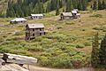
The historic buildings of Animas Forks, a ghost town in San Juan County.
-
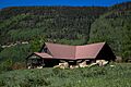
The lodge at Cascade Boy Scout Camp, a place for outdoor adventures.
-
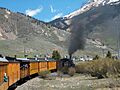
The famous Durango and Silverton Narrow Gauge Railroad, still running today.
-
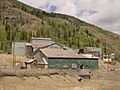
The Shenandoah-Dives (Mayflower) Mill, where ore was processed.
-
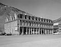
A historic hotel in the Silverton Historic District.


