
National Register of Historic Places listings in San Juan County, New Mexico facts for kids

Welcome to San Juan County, New Mexico! This area is full of amazing places that tell stories about the past. Many of these special spots are listed on the National Register of Historic Places. Think of this register as a very important list of buildings, sites, and objects across the United States that are worth protecting because of their history, architecture, or what they mean to our culture.
In San Juan County, there are 38 places on this special list. Almost all of them are also recognized by the New Mexico State Register of Cultural Properties, which means they are important to the state's history too! Let's explore some of these incredible historic treasures.
Contents
Discovering San Juan County's Historic Treasures
San Juan County is a place where ancient cultures and early settlers left their marks. From old buildings in towns like Aztec and Farmington to mysterious archaeological sites, these places help us understand how people lived long ago. Protecting these sites means we can learn from them and share their stories for many years to come.
Ancient Ruins and Archaeological Sites
San Juan County is home to many fascinating ancient sites, especially those left by the Ancestral Puebloan people. These sites often include old buildings and artifacts that teach us about their way of life.
Aztec Ruins National Monument
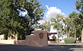
One of the most famous sites is the Aztec Ruins National Monument. It's about a mile north of the town of Aztec. Despite its name, these ruins were built by the Ancestral Puebloans, not the Aztecs of Mexico. This monument protects large, well-preserved structures, including a "Great Kiva" (a large, round ceremonial room) that has been rebuilt. It's a fantastic place to imagine life hundreds of years ago. The Aztec Ruins Administration Building-Museum is also on the list, serving as the main building for visitors to learn about the monument.
Salmon Ruin
Another important Ancestral Puebloan site is the Salmon Ruin, located near Farmington. This ruin was built by people who moved north from Chaco Canyon around 1088 AD. It's a large pueblo with many rooms and kivas, showing how these communities grew and changed over time.
Hidden Archaeological Sites
Many other archaeological sites in San Juan County are listed on the National Register, but their exact locations are kept secret. This is done to protect them from damage and to preserve them for future study. These include places like:
- Archeological Site OCA-CGP-56 (near Fruitland)
- Christmas Tree Ruin (LA 11097) (near Farmington)
- Cottonwood Divide Site (LA 55829) (near Farmington)
- Crow Canyon Archaeological District (near Farmington), which is known for ancient rock carvings called petroglyphs.
- East Side Rincon Site (near Farmington)
- Gallegos Wash Archeological District (near Farmington)
- Hadlock's Crow Canyon No. 1 (LA 55830) (near Farmington)
- Halfway House Archeological Site (near Bloomfield)
- Jaquez Site Ruin (near Farmington)
- Morris' No. 41 Archeological District (near La Plata)
- Prieta Mesa Site (LA 11251) (near Farmington)
- Simon Canyon (LA 5047) (near Farmington), which contains ancient Puebloan structures.
- Site No. OCA-CGP-54-1 (near Fruitland)
- Site OCA-CGP-605 (near Fruitland)
- Star Rock Refuge (LA 55838) (near Farmington)
- Twin Angels Archeological Site (near Bloomfield)
These sites are vital for understanding the ancient history of the region and the people who lived here long before us.
Historic Buildings and Districts in Aztec
The town of Aztec has many historic buildings and even entire areas that are recognized for their unique architecture and history. Many of these were built in the late 1800s and early 1900s.
Aztec Main Street Historic District
The Aztec Main Street Historic District is a special area that includes many important buildings. Walking through this district is like taking a step back in time. It shows what a bustling town center looked like over a hundred years ago.
Notable Homes and Businesses
Several individual buildings in Aztec are also listed:
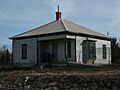
- The H.D. Abrams House (403 N. Church St.) and the Austin-McDonald House (501 Rio Grande) are examples of beautiful old homes.
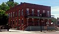
- The American Hotel (300 S. Main) was once a busy place for travelers.
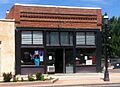
- The Aztec Motor Company Building (301 S. Main) shows the history of cars and businesses in the early 20th century.
- The D.C. Ball House (300 San Juan) is another historic home.
- The Building at 202 Park Avenue and the Building at 500 White Avenue are also recognized.
- The Daws-Keys House (421 N. Church) and the Harvey McCoy House (725 Pioneer) are more examples of historic residences.
- The McCoy-Maddox House and the McGee House (501 Sabena St.) add to the collection of important homes.
- The Engleman-Thomas Building (200 S. Main) was likely an important commercial building.
Church Avenue-Lovers Lane Historic District
This district is another area in Aztec with many historic homes and buildings, showing how the town grew and developed.
Denver and Rio Grande Western Railway Depot
The Denver and Rio Grande Western Railway Depot (314 Rio Grande) is a reminder of when trains were a main way to travel and transport goods. Train depots were often the heart of a town's economy.
Lower Animas Ditch
The Lower Animas Ditch is an important part of Aztec's history, showing how people managed water for farming and daily life. It runs from Church Avenue to the Lovers Lane Historic District.
Farmington's Historic Downtown
Farmington also has its own historic areas that tell stories of its past.
Farmington Historic Downtown Commercial District
This district includes about eight blocks along Main Street and Broadway. It shows the history of businesses and community life in Farmington. Many of the buildings here have unique architectural styles from different periods.
Other Important Structures
Beyond Aztec and Farmington, San Juan County has other significant historic listings.
Florence and John R. Pond House
The Florence and John R. Pond House (1875 NM 170) near La Plata is another example of a historic home that has been preserved.
San Juan River Bridge at Shiprock
The San Juan River Bridge at Shiprock (U.S. Route 491 over the San Juan River) is an important piece of engineering. Bridges are not just ways to cross water; they are also historical markers of transportation and development.
These historic places in San Juan County are like open-air museums, offering a glimpse into the lives of people who shaped this unique part of New Mexico.
Images for kids
-
The American Hotel in Aztec.
-

Image representing an address restricted site.
-
The Aztec Motor Company Building.
-
The Aztec Ruins Administration Building-Museum.
-
Aztec Ruins National Monument.
-
The D.C. Ball House in Aztec.
-
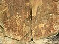
Petroglyphs at Crow Canyon Archaeological District.
-
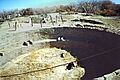
Salmon Ruin.
-
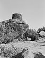
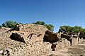
A pueblito in Simon Canyon.


