
National Register of Historic Places listings in Sanders County, Montana facts for kids

This article is about the National Register of Historic Places listings in Sanders County, Montana. The National Register of Historic Places is like an official list of buildings, places, and sites in the United States that are important to history. When a place is on this list, it means it's special and worth protecting because of its past. Sanders County, located in Montana, has 23 different properties and areas that are on this important list. You can even see where some of these places are on a map if their exact location coordinates are shared.
Contents
What is the National Register of Historic Places?
The National Register of Historic Places is the United States government's official list of buildings, districts, objects, sites, and structures that are considered worthy of preservation. It's a way to recognize and protect places that tell a story about America's past. These places might be important because of their architecture, because famous people lived or worked there, or because important events happened there.
Why are these places protected?
When a place is listed on the National Register, it helps people understand its history. It can also make it easier to get grants or tax benefits to help restore and maintain these historic spots. It encourages communities to value and preserve their unique heritage for future generations.
Historic Treasures in Sanders County
Sanders County, Montana, is home to several fascinating places that have earned a spot on the National Register. These sites include old homes, businesses, and even a hydroelectric dam! They tell the story of how people lived and worked in this part of Montana many years ago.
Homes with History
Many of the listed properties in Thompson Falls are historic homes. These houses often show the architectural styles and ways of life from the late 1800s and early 1900s. For example, the Ainsworth House and the Bedard House are two such homes in Thompson Falls that were added to the list in 1986. The Grandchamp House and the Hoyt House are also notable examples, giving us a peek into the past lives of the people who built and lived in them.
Important Buildings and Businesses
Beyond homes, other types of buildings also hold historical value.
- The Gem Saloon in Thompson Falls, listed in 1986, reminds us of the social life and businesses that thrived in early Montana towns.
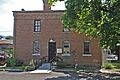
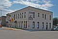
- The IOOF Lodge (Independent Order of Odd Fellows) in Thompson Falls, also listed in 1986, was likely a meeting place for a fraternal organization, which played a big role in community life back then.
- The Northern Pacific Warehouse shows the importance of the railroad in connecting towns and moving goods. It was listed in 1986.
- The Sanders County Jail, listed in 1986, is a significant building that tells a story about law and order in the county's early days.
- The Symes Hotel in Hot Springs, listed in 1998, is a well-known landmark. Hotels were central to travel and community gatherings.
- The Tourist Hotel and Ward Hotel in Thompson Falls, both listed in 1986, also highlight the importance of hospitality and travel in the region's development.
- Weber's Store, listed in 1986, represents the local businesses that served the community.
Unique Historic Sites
Some listings are not just buildings but larger areas or special structures:
- The Bull River Guard Station near Noxon, listed in 1990, is located in the Kootenai National Forest. Guard stations were important for forest management and protecting natural resources.
- The Thompson Falls Hydroelectric Dam Historic District, listed in 1986, is a very important site. This dam on the Clark Fork River was crucial for providing electricity and helping the area grow. It shows how engineering and industry shaped the region.
These places offer a window into the past, helping us understand the history and development of Sanders County, Montana.
Images for kids
-
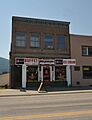
The historic Gem Saloon in Thompson Falls.
-
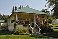
The Grandchamp House, a historic home in Thompson Falls.
-
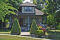
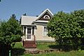
The Hoyt House in Thompson Falls.
-
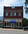
The IOOF Lodge building in Thompson Falls.
-
The Preston House in Thompson Falls.
-
The old Sanders County Jail.
-
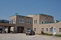
The Symes Hotel in Hot Springs.
-
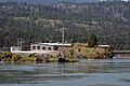
The Thompson Falls Hydroelectric Dam.
-
The Ward Hotel in Thompson Falls.


