
National Register of Historic Places listings in Shelby County, Kentucky facts for kids

Have you ever wondered about the old buildings and special places in your town? In Shelby County, Kentucky, there are many historic spots that are super important to the area's past. These places are so special that they are listed on the National Register of Historic Places. This list helps protect them so future generations can learn from them too!
The National Register of Historic Places is like a special club for buildings, sites, and objects that have played a big role in American history, architecture, archaeology, engineering, or culture. When a place is added to this list, it means it's recognized as a valuable part of our country's heritage.
There are 139 properties and areas in Shelby County that are on this important list. One of them is even a National Historic Landmark, which is an even higher level of recognition!
Contents
What is the National Register of Historic Places?
The National Register of Historic Places is the official list of places in the United States that are worth saving. These places could be buildings, neighborhoods, or even landscapes. They are chosen because they tell important stories about our past.
Why are these places important?
- Learning about history: They help us understand how people lived long ago.
- Protecting special buildings: Listing them helps make sure they are preserved.
- Community pride: They remind us of the unique character of our towns.
Historic Places in Shelby County
Shelby County has a rich history, and its historic places show this. From old homes to churches and even schools, each one has a story.
Homes and Farms with History
Many of the listed places are old homes and farms. These include places like the Allen Dale Farm and the J. B. Allen House. Imagine living in a house that has stood for over a hundred years! These homes often show us how people built and lived in the past.
The Caldwell House in Shelbyville is another example. It's located right where two important roads meet. Many farms, like Basket Farm and Bland Farm, are also on the list. They remind us of Shelby County's farming roots.
Important Public Buildings
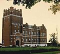
Shelbyville has several public buildings on the list. The Carnegie Public Library is one of them. Libraries like this were often built with money from a famous businessman named Andrew Carnegie. They were important centers for learning.
The Shelby County Courthouse is also a key historic spot. Courthouses are where local government happens and where many important decisions were made over the years.
Churches and Schools
Churches and schools often play a big part in a community's history. The Bethel AME Church in Shelbyville and the Church of the Annunciation are both listed. These buildings served as gathering places for people for many years.
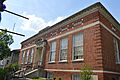
The Buck Creek Rosenwald School is a very special listing. Rosenwald Schools were built for African American children in the early 1900s. They were a big step forward for education during a time of segregation. The Science Hill School is another important educational site.
Unique and Interesting Sites
Some places on the list are quite unique! The Bird Octagonal Mule Barn is an interesting example. It's a barn built in an eight-sided shape, which was unusual.
The Old Stone Inn in Simpsonville was once a place where travelers could stop and rest. Imagine how many people passed through its doors over the years!
The Shelbyville L&N Railroad Depot reminds us of the days when trains were a main way to travel and transport goods.
The Coca-Cola Plant in Shelbyville is also listed. This shows that even industrial buildings can be important parts of history.
National Historic Landmark: Whitney M. Young, Jr. Birthplace
One of the most important sites in Shelby County is the Whitney M. Young, Jr. Birthplace. Whitney M. Young, Jr. was a very important leader in the Civil Rights Movement. His birthplace is recognized as a National Historic Landmark because of his significant contributions to American history.
Images for kids
-
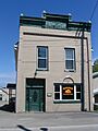
The historic Bank of Simpsonville.
-
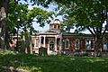
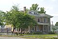
The Bayne House in Shelbyville.
-
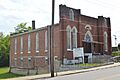
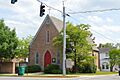
Bethel AME Church in Shelbyville.
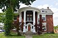
-
The Caldwell House in Shelbyville.
-
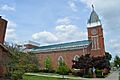
The Carnegie Public Library in Shelbyville.
-
The Church of the Annunciation.
-
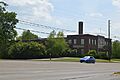
The former Coca-Cola Plant in Shelbyville.
-
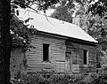
The kitchen of the Cross Keys Tavern.
-
A building in the East Shelbyville District.
-
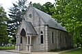
The chapel at Grove Hill Cemetery.
-
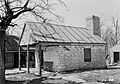
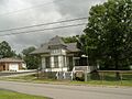
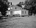
The Dr. Nash House in Clay Village.
-
The historic Old Stone Inn near Simpsonville.
-
Berea Hall at the Lincoln Institute Complex.
-
The St. John United Methodist Church.
-
The main section of Science Hill School.
-
A building in the Seventh Street Historic District.
-
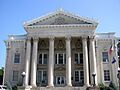
The Shelby County Courthouse.
-
The old L&N Railroad Depot in Shelbyville.
-
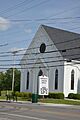
The front of Simpsonville Christian Church.
-

Tevis Cottage in Shelbyville.
-
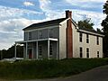
The Thomas Threlkeld House.
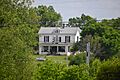
-
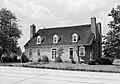
Wickland, a historic home in Shelbyville.
-
The birthplace of Whitney M. Young, Jr.


