
National Register of Historic Places listings in St. Joseph County, Michigan facts for kids

Welcome to St. Joseph County, Michigan! This page is all about the cool, old places in the county that are listed on the National Register of Historic Places. Think of this register as a special list of buildings, areas, and other spots that are super important to American history and culture. When a place is on this list, it means it's worth protecting and remembering for future generations.
In St. Joseph County, there are 16 different places that have made it onto this important list. They include old houses, bridges, and even whole parts of towns! These places help us learn about the past and how people lived long ago.
Contents
- Historic Places in St. Joseph County
- Places That Moved From St. Joseph County
- Images for kids
Historic Places in St. Joseph County
Here's a look at some of the amazing historic places you can find in St. Joseph County:
Constantine's Historic Gems
Constantine is a town with several buildings and even a whole area listed on the National Register.
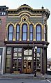
Art Gallery Building
The Art Gallery Building is located at 156 S. Washington Street in Constantine. It was added to the National Register on May 9, 1980. This building has a long history and is recognized for its special architecture and past uses.
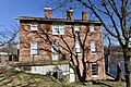
Governor John S. Barry House
The Governor John S. Barry House is found at 280 N. Washington Street. It became a historic site on March 16, 1972. John S. Barry was an important person in Michigan's history, serving as the state's governor three times in the mid-1800s. His home is a great example of the kind of houses important people lived in back then.
Constantine Historic Commercial District
Imagine walking through a part of town where many of the buildings are really old and have a lot of history! That's the Constantine Historic Commercial District. This area includes Washington Street between 2nd and Water Streets, and Water Street itself. It was added to the register on September 17, 1985, because it shows what a busy town center looked like many years ago.
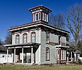
Morse–Scoville House
Another historic home in Constantine is the Morse–Scoville House at 685 S. Washington. This house was listed on July 25, 1996. It's a beautiful example of older homes in the area.
Centreville's Important Buildings
Centreville, the county seat, also has some significant historic spots.
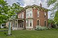
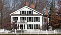
Leverett and Amanda Clapp House
The Leverett A. and Amanda (Hampson) Clapp House is at 324 W. Main Street in Centreville. It was added to the list on July 1, 2009. This house tells a story about the families who lived there and the history of the town.
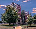
St. Joseph County Courthouse
The St. Joseph County Courthouse is a very important building for the county. Located at 125 W. Main Street, it's where many important decisions and legal matters for the county happen. It was recognized as a historic place on September 16, 1993, because of its architectural style and its role in the county's government history.
Three Rivers' Downtown and Homes
Three Rivers has a lively downtown area and a notable historic house.
Downtown Three Rivers Commercial Historic District
Just like Constantine, Three Rivers has its own historic downtown area. The Downtown Three Rivers Commercial Historic District includes parts of N. Main Street, Michigan Avenue, and Portage Avenue. It was added to the register on April 29, 1982. This district shows how businesses and community life developed in Three Rivers.
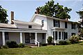
Arthur Silliman House
The Arthur Silliman House is a historic home at 116 S. Main Street in Three Rivers. It was listed on November 20, 1979. It's another example of the beautiful and historic homes in the county.
Colon's Historic Hall
Colon is home to a unique historic building.
Farrand Hall
Farrand Hall is located at 451 Farrand Road in Colon. It became a historic site on August 25, 1972. This hall has been a part of the community for a long time and holds many memories.
Mendon's Bridges and Houses
Mendon features a historic bridge and a house.
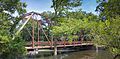
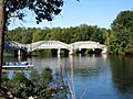
Marantette Bridge
The Marantette Bridge crosses the St. Joseph River on Railroad Street and Buckner Road in Mendon. This bridge was added to the National Register on June 25, 2001. Old bridges like this are important because they show how people traveled and built structures many years ago.
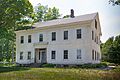
Marantette House
The Marantette House is a historic home at 25538 Simpson Road in Mendon. It was listed on April 11, 1973. It's another example of the historic homes that tell the story of early settlers in the area.
Nottawa's Stone School=
Nottawa has a very special old school building.
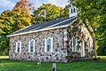
Nottawa Stone School
The Nottawa Stone School is east of Nottawa at the corner of Sturgis and Filmore Roads. It was added to the register on January 13, 1972. Imagine going to school in a building made of stone, built many years ago! This school is a great example of early education buildings.
Mottville and White Pigeon's Landmarks
These areas have a historic bridge, an old government building, and a special monument.
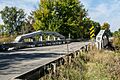
US 12 St. Joseph River Bridge
Another historic bridge, the US 12 St. Joseph River Bridge, carries U.S. Route 12 over the St. Joseph River in Mottville Township. It was listed on April 5, 1991. Bridges are often important landmarks and show how transportation has changed over time.
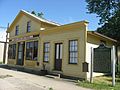
Old US Government Land Office Building
In White Pigeon, you can find the Old US Government Land Office Building at 113 W. Chicago Road. It was added to the register on February 7, 1989. A "land office" was where people went to officially claim and buy land when the country was still growing. This building played a big role in how the area was settled.
Wahbememe Burial Site and Monument
The Wahbememe Burial Site and Monument is a very important historical site located at the junction of U.S. Routes 12 and 131 in Mottville Township, near White Pigeon. It was listed on July 21, 1995. This site honors Chief Wahbememe, also known as Chief White Pigeon, a leader of the Potawatomi people. It's a place to remember and respect the Native American history of the area.
Places That Moved From St. Joseph County
Sometimes, historic items are so important that they are moved to a new location to be preserved or used. Here's an example of a bridge that was once in St. Joseph County but has since moved.
M-86–Prairie River Bridge
The M-86–Prairie River Bridge was originally located on M-86 over the Prairie River in St. Joseph County. This bridge was special because it was a "camelback truss bridge," a type of bridge built in 1923. It actually had a journey of its own! First, it was on Telegraph Road over the Rouge River. Then, in 1938-1939, it was moved to St. Joseph County. After nearly 80 years there, it was moved again in 2016-2017, about 50 miles away, to Crystal Springs Street over the Dowagiac River in Cass County. Even though it's not in St. Joseph County anymore, its history is still connected to the area.
Images for kids
-
The historic Art Gallery Building in Constantine.
-
The former home of Governor John S. Barry.
-
The Leverett A. and Amanda (Hampson) Clapp House.
-

A view of the Constantine Historic Commercial District.
-

The Downtown Three Rivers Commercial Historic District.
-
Farrand Hall in Colon.
-
The Marantette Bridge over the St. Joseph River.
-
The historic Marantette House.
-
The Morse-Scoville House in Constantine.
-
The old Nottawa Stone School.
-
The Arthur Silliman House in Three Rivers.
-
The St. Joseph County Courthouse in Centreville.
-
The US 12 St. Joseph River Bridge.
-
The Old US Government Land Office Building in White Pigeon.
-
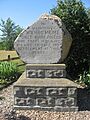
The monument at the Wahbememe Burial Site.
-
The M-86–Prairie River Bridge, which was once in St. Joseph County.


