
National Register of Historic Places listings in Tazewell County, Illinois facts for kids

Welcome to Tazewell County, Illinois! Did you know that many special buildings and places here are officially recognized for their history and importance? They are listed on something called the National Register of Historic Places.
The National Register is like a special list kept by the United States government. It helps protect places that are important to our country's history, architecture, or culture. When a place is on this list, it means it's a valuable part of our past that we should try to save for the future.
In Tazewell County, there are 17 amazing places and areas that have made it onto this important list. Let's explore some of them!
Historic Treasures in Tazewell County
These are some of the cool historic spots you can find in Tazewell County. Each one has a unique story!
Allentown Union Hall
_from_SE_2.jpg)
The Allentown Union Hall is a historic building located about 2 miles east of Illinois Route 121, near the small town of Allentown. It was added to the National Register on August 12, 1988. This hall likely served as an important meeting place for the community in the past.
Ayer Public Library (Delavan)

In Delavan, you'll find the Ayer Public Library at 200 Locust Street. This beautiful library building became a historic place on November 12, 1998. Libraries are often central to a town's history, serving as places of learning and community gathering for many years.
Cemetery Road Bridge (Washington)

The Cemetery Road Bridge is located on Candlewood Drive within Glendale Cemetery in Washington. This bridge was added to the National Register on May 20, 1998. Old bridges can be important examples of how people built things in the past.
Clear Lake Site (Manito)
The Clear Lake Site is a very old and important archaeological site near Manito, located at the junction of 1200E and 2600N in Sand Ridge State Park. It was listed on November 28, 1978. This site is special because it helps us learn about the people who lived in this area long, long ago. Part of this site also extends into Mason County.
Delavan Commercial Historic District

The Delavan Commercial Historic District is not just one building, but a whole area of historic shops and businesses in Delavan. It includes addresses like 307 to 414 Locust Street. This district was recognized on November 14, 1991, because it shows what a busy town center looked like in the past.
Dement-Zinser House (Washington)

The Dement-Zinser House is a historic home at 105 Zinser Place in Washington. It was added to the National Register on November 27, 2002. Old houses like this can tell us a lot about how people lived and the styles of homes they built many years ago.
Denhart Bank Building (Washington)

Also in Washington, the Denhart Bank Building stands at 101 Washington Square. This building became a historic listing on August 12, 2005. Banks were often grand buildings that showed the importance of money and business in a growing town.
Farm Creek Section (East Peoria)

The Farm Creek Section is a natural area on the south side of Farm Creek in East Peoria. It was listed on February 6, 1992. This site is important for understanding the geology of the area, which is how the land was formed over thousands of years.
Carl Herget Mansion (Pekin)

In Pekin, you can find the impressive Carl Herget Mansion at 420 Washington Street. This large home was added to the National Register on August 18, 1992. Mansions often belonged to important people in a town's history and show the fancy architecture of their time.
Illinois Traction System Mackinaw Depot

The Illinois Traction System Mackinaw Depot is located at 301 North Main Street in Mackinaw. This old train station was listed on November 30, 1978. Train depots were once very busy places, connecting towns and helping people and goods travel across the country.
North Eighth Street Plaza (Pekin)

The North Eighth Street Plaza in Pekin, found at 1500-1532 North 8th Street, was added to the National Register on May 18, 2015. Plazas and public spaces are important because they are where communities gather and interact.
Pekin Federal Building

The Pekin Federal Building is located at 334 Elizabeth Street in Pekin. It became a historic listing on October 9, 1980. Federal buildings often house government offices and are built to be strong and important-looking.
Peoria Lock and Dam Historic District (Creve Coeur)
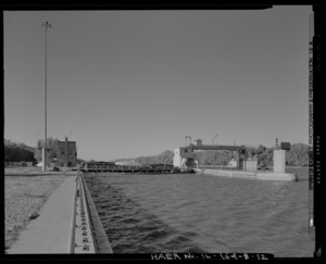
The Peoria Lock and Dam Historic District is a large area at 1071 Wesley Road in Creve Coeur. It was added to the National Register on March 10, 2004. Locks and dams are amazing engineering feats that help boats travel along rivers and control water levels.
St. Louis, Peoria and Northern Railroad Depot (Pekin)

Another important train station, the St. Louis, Peoria and Northern Railroad Depot, is in the 1900 block of Broadway Street in Pekin. It was listed on December 6, 2004. This depot played a key role in connecting Pekin to other cities by rail.
Tazewell County Courthouse (Pekin)

The Tazewell County Courthouse is a very important building in Pekin, located on Court Street between Capitol and Fourth Streets. It was added to the National Register on November 14, 1985. Courthouses are where important legal decisions are made and where much of a county's history takes place.
Third Street Bridge (Delavan)

The Third Street Bridge in Delavan, found on Third Street between Pine and Elm Streets, became a historic listing on May 20, 1999. Like the Cemetery Road Bridge, it's a great example of older bridge construction.
Waltmire Bridge (Tremont)
_from_SW_2.jpg)
The Waltmire Bridge is located on Locust Road over the Mackinaw River, about 4.9 miles south of Tremont. This bridge was added to the National Register on February 5, 1999. It's another example of how important bridges were for travel and trade in the past.
A Former Historic Listing
Sometimes, a place that was once on the National Register of Historic Places might be removed from the list. This usually happens if the building is changed too much, or if it is torn down.
Pekin Theatre
The Pekin Theatre at 21-29 South Capitol Street in Pekin was once a listed historic place, added on October 12, 1982. However, it was later removed from the list on July 30, 1987. This means the building either changed significantly or was no longer standing.
