
National Register of Historic Places listings in Trigg County, Kentucky facts for kids

Have you ever wondered about the oldest and most important buildings and places in your community? The National Register of Historic Places is a special list kept by the United States government. It helps protect places that are important to history, architecture, archaeology, engineering, or culture. When a place is on this list, it means it's recognized as a valuable part of our past.
Contents
What is the National Register?
The National Register of Historic Places is like a hall of fame for historic sites across the country. It helps people learn about and appreciate places that tell a story about how we used to live. Being on the list can also help protect these places from being changed or torn down. It encourages people to take care of them so future generations can enjoy them too.
Historic Places in Trigg County
Trigg County, Kentucky, has several amazing places that are listed on the National Register of Historic Places. These sites help us understand the rich history of the area, from old buildings to important monuments. Let's explore some of them!
Brick Inn
The Brick Inn is a historic building located off Kentucky Route 80 in Canton. It was added to the National Register on April 10, 1980. This old inn likely served as a resting place for travelers many years ago, offering a glimpse into the past.
Cadiz Downtown Historic District
The heart of Cadiz, Kentucky, has a special historic area called the Cadiz Downtown Historic District. This district includes many buildings along Main Street, from Scott Street to Franklin Street. It was recognized on November 14, 1988, for its important collection of historic buildings that show what the town looked like long ago.
Cadiz Main Street Residential District
Just like the downtown area, a part of Main Street in Cadiz is also a historic district, but this one focuses on homes! The Cadiz Main Street Residential District includes houses between Line Street and Scott Street. It was added to the National Register on May 16, 1989. These homes show different styles of architecture from the past.
Cadiz Masonic Lodge
The Cadiz Masonic Lodge No. 121 F. and A.M. is a historic building located at Jefferson and Monroe Streets in Cadiz. It became a protected site on April 17, 1979. Masonic lodges are meeting places for a very old and well-known social organization. This building has been a part of the community for many years.
Center Furnace
The Center Furnace is a fascinating historical site located between Honker and Hematite Lakes within the Land Between the Lakes National Recreation Area. It was listed on the National Register on May 12, 1977. This furnace was likely used to make iron a long time ago, playing a role in the early industries of the region.
Confederate Monument of Cadiz
On the Courthouse Lawn in Cadiz, you'll find the Confederate Monument of Cadiz. This monument is about 0.5 miles east of the junction of Kentucky Routes 139 and 1175. It was added to the National Register on July 17, 1997. Monuments like this help us remember important events and people from history, like the American Civil War.
Thomas Dawson House
The Thomas Dawson House is a historic home located south of Cadiz. It was recognized as a historic place on December 1, 1980. Old houses like this one often have unique architectural styles and can tell us a lot about how families lived in the past.
John McCaughan House
Another historic home in the area is the John McCaughan House, found on Kentucky Route 276 near Cadiz. It was added to the National Register on January 8, 1987. These old homes are important because they preserve the history and character of the region.
Images for kids
-
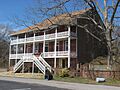
The historic Brick Inn in Canton
-
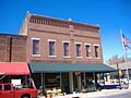
Cadiz City Hall, part of the Downtown Historic District
-
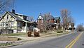
A street view in the Cadiz Main Street Residential District
-
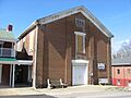
The Cadiz Masonic Lodge building
-

The Confederate Monument on the Courthouse Lawn in Cadiz


