
National Register of Historic Places listings in Valley County, Idaho facts for kids

Welcome to Valley County, Idaho! This place is full of amazing history. Imagine buildings, old ranches, and even bridges that have been around for many years. These special spots are so important that they are listed on the National Register of Historic Places. This is like a special list kept by the United States government. It helps protect places that tell us about the past.
In Valley County, there are 26 places on this list. Each one has a unique story. They help us understand how people lived, worked, and built communities long ago. Let's explore some of these cool historic sites!
Contents
Historic Places in Valley County
Many of the places on the National Register in Valley County are old homesteads and buildings. These show us how early settlers lived and built their lives in Idaho.
Old Homes and Ranches
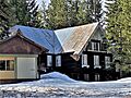
- Elo School: This old school building in McCall was added to the list in 1982. It reminds us of how kids used to learn many years ago.
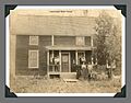
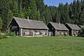
- Matt N. Hill Homestead Barn: Also near McCall, this barn was part of a homestead. It shows how important farming and ranching were.
- Thomas Jarvi Homestead: Located east of Lake Fork, this homestead was added in 1982. It tells the story of a family settling in the area.
- John G. Johnson (Rintakangas) Homestead: Northeast of Lake Fork, this homestead is another example of early family life.
- John S. Johnson (Sampila) Homestead: Also near Lake Fork, this homestead shows the spread of settlers in the region.
- John Korvola Homestead: Found near Donnelly, this homestead was listed in 1982. It highlights the history of farming in the area.
- Charles Koski Homestead: Southeast of McCall, this homestead is another piece of the puzzle of early Valley County life.
- Gust Laituri Homestead: Northeast of Lake Fork, this homestead was added in 1982. It represents the hard work of pioneers.
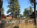
- Jacob and Herman Mahala Homestead: North of Donnelly, this homestead tells the story of families working together.
- Jacob Maki Homestead: Near Donnelly, this homestead was listed in 1982. It shows the types of homes built by early settlers.
- Herman Ojala Homestead: Northeast of Lake Fork, this homestead is another example of the many families who settled here.
- Matt Ruatsale Homestead: North of Kantola Lane near Lake Fork, this homestead was added in 1982. It helps us remember the past.
- Nickolai Wargelin Homestead: Southeast of McCall, this homestead is one more example of the historic homes in the county.
Important Buildings and Sites
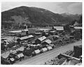
- Big Creek Commissary: This building in Yellow Pine, located in the Payette National Forest, was listed in 2000. A commissary was a store where workers could buy supplies.
- Braddock Gold Mining and Milling Company Log Building and Forge Ruins: Near Thunder City, these ruins show us where gold mining used to happen. It was a big part of Idaho's history.
- Cabin Creek Ranch: This ranch is deep in the Payette National Forest. It was added to the list in 1990. Ranches were very important for food and supplies.
- Johnson Flying Service Hangar: In McCall, this hangar was listed in 2019. It reminds us of the history of aviation and how planes helped connect remote areas.
- Krassel Ranger Station: This station is along the Salmon River, west of Yellow Pine. It was listed in 1992. Ranger stations are important for managing forests and protecting nature.
- Long Valley Finnish Church: Southeast of Lake Fork, this church was built by Finnish settlers. It was added to the list in 1980 and is a special place for the community's history.
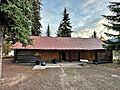
- McCall District Administrative Site: In McCall, this site was listed in 1991. It was an important place for managing the local area.
- North Fork Payette River Bridge: This bridge near Smiths Ferry was built in 1999. Bridges are vital for travel and connecting communities.
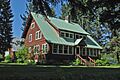
- Payette Lakes Club: This club in McCall was listed in 2017. It shows how people spent their free time and built communities.
- Rice Meetinghouse: Northeast of McCall, this meetinghouse was added in 1980. It was a place where people gathered for meetings or worship.
- Southern Idaho Timber Protective Association (SITPA) Buildings (McCall, Idaho): These buildings in McCall were listed in 1990. They show the history of protecting forests from fires.
- Southern Idaho Timber Protective Association (SITPA) Buildings (Smiths Ferry, Idaho): Similar buildings near Smiths Ferry were also listed in 1990, showing the importance of timber protection across the region.
- Stibnite Historic District: This area near Yellow Pine was a mining district. It was listed in 1987 and tells the story of mining in Idaho.
Places No Longer Listed
Sometimes, a historic place might be removed from the National Register. This can happen for different reasons.
- Brown Tie and Lumber Company Mill and Burner: This mill in McCall was listed in 1978 but was removed in 1986. Sadly, it was destroyed by a fire.
Images for kids
-
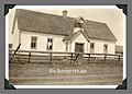
The historic Elo School in McCall.
-

The Matt N. Hill Homestead Barn.
-

The Johnson Flying Service Hangar in McCall.
-

The site of the John G. Johnson Homestead.
-

The John S. Johnson (Sampila) Homestead.
-

The John Korvola Homestead.
-
The Charles Koski Homestead.
-

The Gust Laituri Homestead.
-
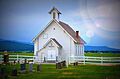
The Long Valley Finnish Church.
-

The Jacob and Herman Mahala Homestead.
-

The Jacob Maki Homestead.
-

The McCall District Administrative Site.
-
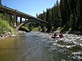
The North Fork Payette River Bridge.
-
The Payette Lakes Club.
-
The Rice Meetinghouse.
-

The Matt Ruatsale Homestead.
-
A Southern Idaho Timber Protective Association building in McCall.
-
Southern Idaho Timber Protective Association buildings in Smiths Ferry.
-
The Stibnite Historic District in 1942.
-
The Nickolai Wargelin Homestead.


_NRHP_82000364_Valley_County,_ID.jpg)
_Homestead.JPG)


.JPG)

.JPG)


.jpg)


.JPG)


