
National Register of Historic Places listings in Vermilion County, Illinois facts for kids

Vermilion County, Illinois, is home to many special places that are listed on the National Register of Historic Places. This is an official list kept by the United States government. It helps protect important buildings, sites, and objects that tell us about American history, architecture, archaeology, engineering, and culture. Think of it like a hall of fame for historic spots!
In Vermilion County, there are 13 places currently on this list. These sites help us learn about the past and understand how people lived long ago. Two other places were once on the list but have since been removed. Let's explore some of these amazing historic treasures!
Contents
Historic Places in Danville
Most of Vermilion County's historic places are found in the city of Danville. These sites show us different parts of the city's past, from old buildings to important community spots.
Old Buildings and Theaters
- Adams Building: Located at 139-141 N. Vermilion Street, this building was added to the Register in 2000. It's an example of the kind of architecture that was popular in Danville around that time.
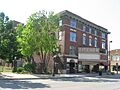
- Dale Building: Just down the street at 101-103 N. Vermillion Street, the Dale Building also joined the Register in 2000. These buildings remind us of how downtown Danville used to look.
- Fischer Theatre: Found at 158-164 N. Vermillion Street, the Fischer Theatre became a historic place in 2001. Theaters like this were once very popular for movies and live shows, bringing entertainment to the community.
- Holland Apartments: These apartments at 324-326 N. Vermilion Street were listed in 1988. They show us how people lived in multi-family homes in the past.
- United States Post Office and Court House: This important building at 201 North Vermilion Street was added to the Register in 2016. It has served as a place for mail and legal matters for many years.
Community and Service Sites
- Danville Branch, National Home for Disabled Volunteer Soldiers Historic District: This large area at 1900 and 2000 E. Main Street became a historic district in 1992. It was once a special home for soldiers who had served their country and needed care. It includes the Danville National Cemetery, where many veterans are buried.
- Danville Public Library: The building at 307 N. Vermillion Street was listed in 1978 because of its history as a public library. Today, this building has a new purpose: it serves as the Vermilion County War Museum, honoring those who served in wars.
Unique Historic Spots
- Collins Archeological District: This fascinating area is located west of Lake Mingo at Kennekuk County Park. It was added to the Register in 1979. An "archeological district" means it's a place where scientists study old human history by digging up artifacts. This site has been part of Kennekuk County Park since the 1970s, helping to protect its ancient secrets.
- Fithian House: You can find this historic home at 116 N. Gilbert Street. It was listed in 1975. Homes like the Fithian House give us a glimpse into the daily lives of people from earlier times.
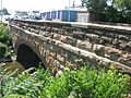
- Stone Arch Bridge: This bridge, located at 760-800 E. Main Street, was recognized in 1986. Stone arch bridges are special because of their strong and beautiful design, often built many years ago to last a long time.
Historic Places in Hoopeston
Hoopeston, another city in Vermilion County, also has its own important historic sites.
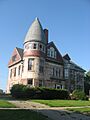
- Hoopes-Cunningham Mansion: This grand house at 424 E. Penn Street was added to the Register in 1985. Mansions often tell stories of important families or the way wealthy people lived in the past.
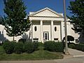
- Hoopeston Carnegie Public Library: Located at 110 N. Fourth Street, this library building became historic in 2002. Carnegie libraries were built all over the United States with money donated by Andrew Carnegie, a famous businessman, to help communities have access to books and learning.
Former Historic Listings
Sometimes, a place that was once on the National Register of Historic Places might be removed. This usually happens if the building is changed too much or is no longer standing.
- Temple Building: This building, once at 102-106 N. Vermilion Street in Danville, was listed in 2000 but removed in 2002. It was later taken down by the City of Danville.
These historic places in Vermilion County are important reminders of the past. They help us understand the history of Illinois and the United States, and they are protected so future generations can learn from them too!
Images for kids
-
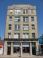
The Adams Building in Danville.
-
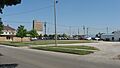
This lot was once the site of a historic building.
-

The Collins Archeological District, where ancient history is explored.
-

The historic Dale Building in Danville.
-

Gravestones at the Danville National Cemetery, part of a historic district.
-

The building that now houses the Vermilion County War Museum.
-
The Fischer Theatre, a historic entertainment venue.
-

The Fithian House, a historic home in Danville.
-
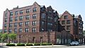
The Holland Apartments in Danville.
-
The Hoopes-Cunningham Mansion in Hoopeston.
-
The Hoopeston Carnegie Public Library.
-
The Stone Arch Bridge in Danville.
-

The United States Post Office and Court House in Danville.
-
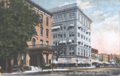
A postcard showing the former Temple Building.


