
National Register of Historic Places listings in Wasatch County, Utah facts for kids

Hey there! Have you ever wondered about the old buildings and special places in your community? Many of them have amazing stories! In Wasatch County, Utah, there's a special list called the National Register of Historic Places. This list helps protect important buildings, sites, and objects that have played a big part in American history, architecture, archaeology, engineering, or culture.
When a place is added to this list, it means it's recognized as super important for everyone to remember and take care of. It's like giving a building a special badge of honor! In Wasatch County, there are 36 places currently on this list. A few others were once listed but have since been removed. Let's explore some of these cool historic spots!
Contents
Cool Places on the Historic List
Here are some of the interesting homes and buildings in Wasatch County that are on the National Register of Historic Places. Each one has a unique story!
Heber City Homes and Buildings
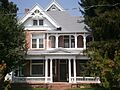
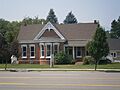
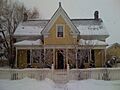
- Austin–Wherritt House: Located at 315 East Center Street, this house was added to the list on January 25, 1979.
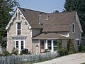
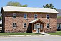
- George Blackley House: You can find this house at 421 East 200 North. It became historic on June 27, 1985.
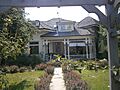
- Clotworthy–McMillan House: This home at 261 South Main Street joined the list on February 12, 1999.
- James William Clyde House: At 312 South Main Street, this house was recognized on October 18, 1996.
- Heber and Matilda Crook House and Lake Creek Schoolhouse: These two historic spots are together at 4800 East Lake Creek Road. They were added on April 17, 1995.
- John Crook House: This house at 188 West 3rd North became historic on November 16, 1978.
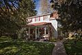
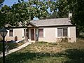
- David Fisher House: Located at 124 East 400 South, this house was added on April 16, 1980.
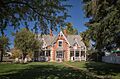
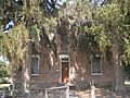
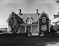
- Abram Hatch House: Found at 81 East Center Street, this important house joined the list on October 10, 1975.
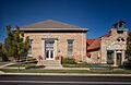
- Heber Second Ward Meetinghouse: This building, at 1st West and Center Streets, was listed on December 12, 1978.
- John Murdoch House: At 261 North 400 West, this house became historic on February 28, 1980.
- Joseph S. Murdock House: This home at 115 East 300 North was added on May 1, 1987.
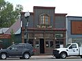
- Wasatch Saloon: This old saloon at 139 North Main Street was recognized on September 23, 1980.
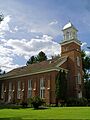
- Wasatch Stake Tabernacle and Heber Amusement Hall: These two important buildings are at Main Street, 100 North Street, and 100 West Street corners. They were listed on December 2, 1970.
- Wasatch Wave Publishing Company Building: This building at 55 West Center Street was added on December 27, 1979. It was taken down around the year 2000.
Midway's Historic Gems
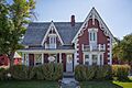
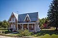
- George Bonner Jr House: Located at 90 East Main Street, this house was designed by John Watkins and listed on June 17, 1986.
- George Bonner Sr. House: Also designed by John Watkins, this house at 103 East Main Street was added on June 17, 1986.
- William Bonner House: At 110 East Main Street, this home joined the list on June 17, 1986.
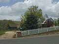
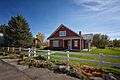
- Burgener–Boss Farmstead: This farm at 102 West 100 North was recognized on May 26, 1994.
- William Coleman House: You can find this house at 180 North Center Street. It was listed on June 17, 1986.
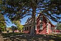
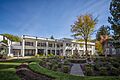
- John Huber House and Creamery: This historic spot is off Snake Creek Canyon Road and is part of Wasatch Mountain State Park. It was added on August 11, 1988.
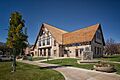
- Midway Social Hall: At 71 East Main Street, this hall became historic on August 10, 1995.
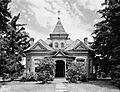
- Midway Town Hall: This important town building at 120 West Main Street was listed on December 1, 1994.
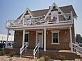
- Schneitter Hotel: Located at 700 North Homestead Drive, this hotel was added on December 17, 1992.
- Snake Creek Hydroelectric Power Plant Historic District: This power plant district is off Snake Creek Canyon Road and is part of Wasatch Mountain State Park. It was recognized on April 21, 1989.
- John and Margaret Watkins House: At 22 West 100 South, this house joined the list on June 17, 1986.
- Watkins-Coleman House: This house at 5 East Main Street was designed by John Watkins and listed on May 14, 1971.
- Wilson House and Farmstead: Located at 94 East 250 North, this farm was added on July 3, 2007.
- Attewall Wootton Jr House: You can find this house at approximately 285 East Main Street. It became historic on April 10, 1980.
Woodland's Ranch Houses
Several ranch houses in Woodland, off State Route 35, are also on the list:
- Lester F. and Margaret Stewart Hewlett Ranch House: Listed on May 23, 1985.
- Stewart Ranch Foreman's House: Added on May 23, 1985.
- Barnard J. Stewart Ranch House: Recognized on May 23, 1985.
- Charles B. Stewart Ranch House: Joined the list on May 23, 1985.
- Samuel W. Stewart Ranch House: Listed on May 23, 1985.
- Stewart–Hewlett Ranch Dairy Barn: This barn was added on May 23, 1985.
- Ethelbert White and William M. Stewart Ranch House: Recognized on May 23, 1985.
Places No Longer on the List
Sometimes, a historic place might be removed from the National Register. This can happen if the building is changed too much, or if it's destroyed.
- Cloud Rim Girl Scout Lodge: This lodge near Brighton was listed on April 9, 1986. Sadly, it was destroyed by fire in November 1992 and removed from the list on February 1, 1995. A new lodge was built in 1999.
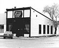
- Midway School: This school at First North and First West in Midway was listed on March 29, 1978, but was removed on April 17, 1986.
Images for kids
-
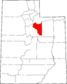
Location of Wasatch County in Utah
-
Austin–Wherritt House
-
George Blackley House
-
George Bonner Jr House
-
George Bonner Sr. House
-
William Bonner House
-
Burgener–Boss Farmstead
-
Clotworthy–McMillan House
-
James William Clyde House
-
William Coleman House
-
Heber and Matilda Crook House and Lake Creek Schoolhouse
-
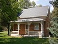
John Crook House
-
David Fisher House
-
Abram Hatch House
-
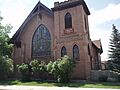
Heber Second Ward Meetinghouse
-
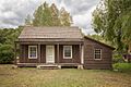
John Huber House and Creamery
-
Midway Social Hall
-
Midway Town Hall
-
John Murdoch House
-
Joseph S. Murdock House
-
Schneitter Hotel
-

Snake Creek Hydroelectric Power Plant Historic District
-
Wasatch Saloon
-
Wasatch Stake Tabernacle and Heber Amusement Hall
-
Wasatch Wave Publishing Company Building
-
John and Margaret Watkins House
-
Watkins-Coleman House
-
Wilson House and Farmstead
-
Attewall Wootton Jr House


