
National Register of Historic Places listings in Washington County, Texas facts for kids

Washington County, Texas, is home to many amazing places that are important to history! These special spots are listed on the National Register of Historic Places. This is like a special club for buildings, areas, and objects that tell us about the past of the United States.
When a place is on this list, it means it's worth protecting and learning about. It helps us remember the people and events that shaped our country. In Washington County, you can find old homes, schools, churches, and even a famous ice cream factory that are all part of this important list!
Contents
Historic Places in Washington County
Washington County has many buildings and areas that are officially recognized for their history. Here are some of the cool places you can find:
Brenham's Historic Gems
Brenham is a city in Washington County with lots of historic buildings.
Blue Bell Creameries Complex

Did you know the famous Blue Bell ice cream factory is a historic place? The Blue Bell Creameries Complex at 602 Creamery was added to the list in 1990. It's cool to think that a place where so much delicious ice cream is made has such a long history!
Brenham Downtown Historic District

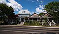
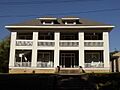
The heart of Brenham, known as the Brenham Downtown Historic District, became a historic district in 2004. This area includes many old buildings that show what the town looked like long ago. It's bounded by streets like W. Vulcan, E. Vulcan, and South Market. Walking through here is like taking a step back in time!
Old Schools of Brenham
Brenham has several old school buildings that are now historic sites:
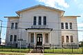
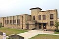
- The Old Brenham High School at 1301 S. Market was listed in 1990. Imagine all the students who walked those halls!
- Right next to it, the Brenham High School Gymnasium was also listed in 1990. Many games and events must have happened there.
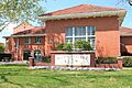
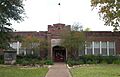
- The Brenham School at 600 E. Alamo is another old school building from 1990. These buildings remind us how important education has always been in the community.
Blinn College

Blinn College is a historic district itself, added in 1990. The Main Building, Blinn College at 804 College Avenue was specifically listed in 1978. This college has been educating students for a very long time and has a rich history.
Important Houses in Brenham
Many old homes in Brenham are also historic:
- The Bassett and Bassett Banking House (1983) at 222 E. Main Street.
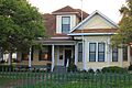
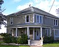
- The Becker-Hildebrandt House (1990) at 1402 S. Church.
- The Brockschmidt-Miller House (1990) at 806 S. Day.
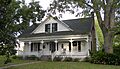
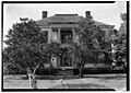
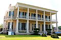
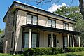
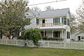
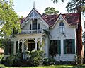
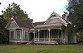
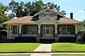
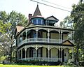
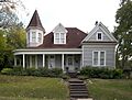
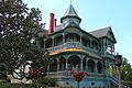
- The Giddings-Stone Mansion (1976) at 204 E. Stone Street is a beautiful old home.
- The Giddings-Wilkin House (1976) at 805 Crocket Street.
- The Edmund Holle House (1990) at 1002 S. Day.
- The Dr. Robert Lenert House (1990) at 602 S. Market.
- The Edgar Matchett House (1990) at 502 W. Main.
- The Pampell-Day House (1970) at 409 W. Alamo Street.
- The Reichardt-Low House (1990) at 609 S. Austin.
- The Reue-Eickenhorst House (1995) on FM Hwy. 2621.
- The Almot Schlenker House (1990) at 405 College.
- The Schlenker-Kolwes House (1990) at 1304 S. Market.
- The Schmidt House (1990) at 906 W. 5th Street.
- The Fritz Paul and Emma Schroeder House (1994) on Co. Rd. 68.
- The F. W. Schuerenberg House (1990) at 503 W. Alamo.
- The R. A. Schuerenberg House (1990) at 703 S. Market.
- The W. E. Seelhorst House (1990) at 702 Seelhorst.
- The Wood-Hughes House (1990) at 614 S. Austin.
Other Brenham Landmarks
- The Brenham Water Works (1990) at 1105 S. Austin, which helped provide water to the city.
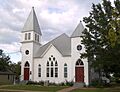
- The Mt. Zion Methodist Church (1990) at 500 High.
- The Santa Fe Railway Company Freight Depot (1990) at 214 S. Austin, an old train station.
- The Southern Pacific Railroad Freight Depot (1990) at 306 S. Market, another important train building.
- St. Mary's Catholic Church (1990) at 701 Church.
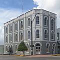
- The Synagogue B'nai Abraham (1990) at 302 N. Park, an important religious building.
- The US Post Office-Federal Building-Brenham (1990) at 105 S. Market.
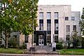
- The Washington County Courthouse (1990) at 110 E. Main, where many important decisions for the county have been made.
Chappell Hill's Rich History
Chappell Hill is another town in Washington County with many historic places.
The Stagecoach Inn

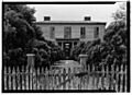
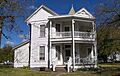
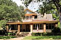
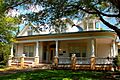
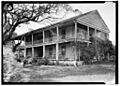
The Stagecoach Inn of Chappell Hill at 4950 Main Street is a very special place, listed in 1976. This 14-room inn was built in 1850 and is the oldest building in Chappell Hill! It was once a busy stop for stagecoaches and a telegraph office, connecting cities like Houston and Austin. It even served as a boarding house for college students.
Chappell Hill's Historic Buildings
- The Isaac Applewhite House (1985) on Church Street.
- The W. W. Browning House (1972) south of Chappell Hill.
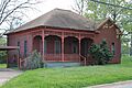
- The Chappell Hill Circulating Library (1985) on Cedar Street, an old library.
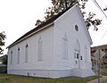
- The Chappell Hill Methodist Episcopal Church (1985) on Church Street.
- The Chappell Hill Public School and Chappell Hill Female College Bell (1985) on Poplar Street.
- The E. King Felder House (1985) on Haller Street.
- The Main Street Historic District (1985) covers Main Street, showing the historic layout of the town.
- The William S. Rogers House (1985) on Cedar Street.
- The J. R. Routt House (1985) on Chestnut Street.
- The John Sterling Smith Jr. House (1985) on Chestnut Street.
- Waverly (1983) on FR 2447.
Burton's Historic Sites
Burton also has several places on the National Register.
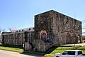
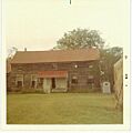
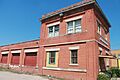
Burton Farmers Gin
.jpg)
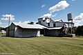
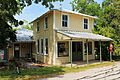
The Burton Farmers Gin at Main Street southeast of Burton Street was listed in 1991. A "gin" is a machine that separates cotton fibers from their seeds. This place is important because cotton farming was a big part of Texas history.
Other Burton Historic Places
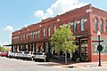
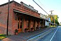
- The Burton Commercial Historic District (1991) includes many old shops and buildings in the town center.
- The Burton High School (1991) at the junction of Main Street and FM 390.
- The Hodde Drugstore (1991) on Main Street.
- The Kneip-Bredthauer House (1991) at the SE corner of Colorado and Cedar.
- The Dr. Charles Laas House (1991) at the NE corner of Live Oak and Colorado Streets.
- The William Neumann House (1991) on Navasota Street.
- The Herbert Nienstedt House (1991) at the NE corner of Brazos and Washington Streets.
- The William Nienstedt House (1991) at the SE corner of Brazos and Texas Streets.
- The William Edward Sanders House (1991) on Railroad Street.
- The Wehring Shoe Shop and Residence (1991) on Main Street.
Independence and Other Areas
Mrs. Sam Houston House

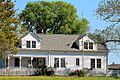
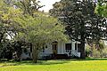
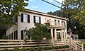
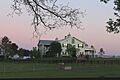
The Mrs. Sam Houston House in Independence, listed in 1970, is a very important historic home. It's located on FM 390. This was the home of Margaret Lea Houston, the wife of Sam Houston, a very famous figure in Texas history!
Seward Plantation

The Seward Plantation at 10005 FM 390 E in Independence was added to the list in 2013. Plantations were large farms, and this one has a long history.
Other Notable Places
- The John M. Brown House (1975) south of Washington on FM 912.
- The Asa Hoxey House (1976) west of Independence.
- The James Walker Log House (1989) on Co. Rd. 80 near Brenham.
Images for kids
-
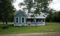
Isaac Applewhite House
-
Bassett and Bassett Banking House
-

Becker-Hildebrandt House
-
Blinn College
-

Blue Bell Creameries Complex
-
Brenham Downtown Historic District
-

Old Brenham High School
-
Brenham High School Gymnasium
-
Brenham School
-

Brenham Water Works
-
Brockschmidt-Miller House
-
John M. Brown House
-
W. W. Browning House
-
Burton Commercial Historic District
-
Burton Farmers Gin
-
Burton High School
-

Chappell Hill Circulating Library
-
Chappell Hill Methodist Episcopal Church
-
Chappell Hill Public School and Chappell Hill Female College Bell
-

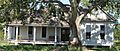
East Brenham
-
E. King Felder House
-
Giddings-Stone Mansion
-
Giddings-Wilkin House
-

Hodde Drugstore
-
Edmund Holle House
-

Mrs. Sam Houston House
-
Asa Hoxey House
-
Kneip-Bredthauer House
-
Dr. Charles Laas House
-

Dr. Robert Lenert House
-

Main Building, Blinn College
-
Main Street Historic District (Chappell Hill)
-
Edgar Matchett House
-

Mt. Zion Methodist Church (Brenham, Texas)
-
William Neumann House
-

Herbert Nienstedt House
-

William Nienstedt House
-
Pampell-Day House
-

Reichardt-Low House
-
Reue-Eickenhorst House
-
William S. Rogers House
-
J. R. Routt House
-
William Edward Sanders House
-

Santa Fe Railway Company Freight Depot
-
Almot Schlenker House
-

Schlenker-Kolwes House
-
Schmidt House (Brenhamm, Texas)
-
Fritz Paul and Emma Schroeder House
-
F. W. Schuerenberg House
-
R. A. Schuerenberg House
-
W. E. Seelhorst House
-
Seward Plantation
-
John Sterling Smith Jr. House
-
Southern Pacific Railroad Freight Depot (Brenham, Texas)
-

St. Mary's Catholic Church (Brenham, Texas)
-
Stagecoach Inn of Chappell Hill
-
Synagogue B'nai Abraham, Brenham
-

US Post Office-Federal Building-Brenham
-
Washington County Courthouse (Texas)
-
Waverly (Chappell Hill, Texas)
-
Wehring Shoe Shop and Residence
-
Wood-Hughes House


.jpg)


.jpg)


