
National Register of Historic Places listings in White County, Illinois facts for kids

Have you ever wondered about the oldest and most special places in your area? In White County, Illinois, there are several amazing spots that are so important, they've been added to a special list called the National Register of Historic Places. This list helps protect buildings, sites, and objects that tell us about America's past.
These places are like time capsules, showing us how people lived, worked, and built things many years ago. From ancient village sites where people lived thousands of years ago to grand old houses and important bridges, each spot has a unique story. There are 11 of these special places in White County. Let's explore some of them!
Contents
Exploring White County's Historic Places
Ancient Village Sites
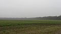
White County is home to some very old places where people lived long, long ago. These sites help us learn about the first people who called this land home.
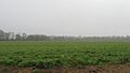
Bieker-Wilson Village Site
The Bieker-Wilson Village Site is an ancient place near New Haven. It's where archaeologists have found clues about early villages. Imagine people living here, hunting, farming, and building homes thousands of years ago! This site helps us understand how communities were formed in the past.
Hubele Mounds and Village Site
Near Maunie, you'll find the Hubele Mounds and Village Site. Mounds are large hills of earth built by ancient people, often for burials or ceremonies. This site shows us that people lived here and built these impressive structures a very long time ago. It's a window into their culture and way of life.
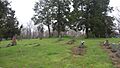
Wilson Mounds and Village Site
Another fascinating ancient spot near Maunie is the Wilson Mounds and Village Site. Like Hubele, this area includes mounds and evidence of an old village. It's located near the Marshall Ferry Cemetery. These sites are important because they teach us about the history of Native Americans in Illinois.
Historic Buildings in Carmi
Carmi, a city in White County, has several beautiful old buildings that are on the National Register. These buildings show us the history of the town and how people lived there.
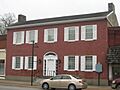
Carmi Chapter House
The Carmi Chapter House, located on West Main Street, is a historic building that was added to the list in 1980. It's a great example of the architecture from its time and tells us about the community groups that used it.
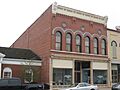
L. Haas Store
The L. Haas Store on East Main Street is another historic building in Carmi. This old store reminds us of a time when local shops were the heart of a community. It was added to the National Register in 1994.
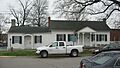
Ratcliff Inn
The Ratcliff Inn, also on East Main Street in Carmi, is a very old inn. An inn was like a hotel where travelers could stay. This building has seen many people come and go over the years and holds many stories from the past. It became historic in 1973.
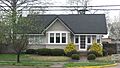
Robinson-Stewart House
The Robinson-Stewart House, found on South Main Cross Street, is a beautiful historic home in Carmi. It was recognized for its importance in 1973. Homes like this give us a glimpse into the lives of families who lived in Carmi many years ago.
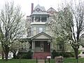
James Robert Williams House
Another notable house in Carmi is the James Robert Williams House on East Main Street. This house was added to the National Register in 1987. It stands as a reminder of the architectural styles and family histories of the area.
Other Important Structures
Beyond ancient sites and Carmi's buildings, White County has other unique historic places.
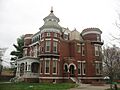
William W. Gray House
In Grayville, you can find the William W. Gray House. What makes this house extra special is that it was designed by a famous architect named George Franklin Barber. He was known for his beautiful and detailed house designs. This house was listed in 1992.
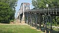
Harmony Way Bridge
The Harmony Way Bridge, also known as the New Harmony Toll Bridge, connects Illinois and Indiana. It's a big, important bridge that crosses the Wabash River. Bridges like this are not just ways to get from one place to another; they are also amazing examples of engineering from their time. This bridge was added to the list in 2007.
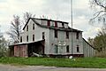
Old Morrison Mill
Near Burnt Prairie, you'll find the Old Morrison Mill. A mill is a building where grain was ground into flour. Mills were very important for communities in the past because they helped produce food. This old mill tells us about the farming history of White County and was listed in 1984.
These historic places in White County are important parts of our shared history. They help us remember the past and understand how our communities grew and changed over time.
Images for kids
-
Bieker-Wilson Village Site
-
Carmi Chapter House
-
William W. Gray House
-
L. Haas Store
-
Harmony Way Bridge
-
Hubele Mounds and Village Site
-
Old Morrison Mill
-
Ratcliff Inn
-
Robinson-Stewart House
-
James Robert Williams House
-
Wilson Mounds and Village Site


