Near East Side (Columbus, Ohio) facts for kids
The Near East Side is a neighborhood located close to downtown Columbus, Ohio. It's actually made up of several smaller neighborhoods like Mount Vernon, King-Lincoln Bronzeville, Eastgate, Franklin Park, Nelson Park, Olde Towne East, and Woodland Park.
Contents
- History of the Near East Side
- Geography of the Near East Side
- Development in the Near East Side
- Population of the Near East Side
- Education in the Near East Side
- Historic Districts in the Near East Side
- Neighborhoods in the Near East Side
- Structures and Landmarks in the Near East Side
- Parks in the Near East Side
- Near East Area Commission
History of the Near East Side
After the Civil War, the city of Columbus started growing very quickly. A new streetcar system helped people live further from their jobs. Areas along major roads grew even more, and the city expanded all the way to Alum Creek. At this time, the Near East Side was a fancy and rich community. It had many big, beautiful homes, successful businesses, and a lively art scene.
By the 1920s, the Near East Side had its own special feel and a group of unique neighborhoods. Hamilton Park and Long Street became a wealthy African American neighborhood. It was full of shops, theaters, offices, restaurants, and many clubs that played jazz music.
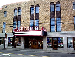
The area had five movie theaters close to each other: Dunbar Theater, The Cameo, The Pythian Theater (now part of the King Arts Complex), Lincoln Theater, and Empress Theater.
In the early 1940s, Poindexter Village opened in the Near East Side. It was one of the first public housing projects in the country. It was named after Reverend James Preston Poindexter, who was the first African American City Council Member in Columbus.
As more people started owning cars, the Near East Side changed again. New shopping centers and suburbs altered how cities looked. Two big changes in the 1960s were the building of the interstate highways: Interstate 71 (north and south) and Interstate 70 (east and west). These new highways created a strong barrier that separated Broad Street from downtown. However, highway exits directly into the area also helped new businesses grow.
Geography of the Near East Side
The Near East Side is surrounded by major highways and a creek. To the north is I-670, to the south is I-70, to the east is Alum Creek, and to the west is I-71.
This area is about 2.5 square miles. It sits right to the east of where the city of Columbus was first planned in 1812.
U.S. Route 40 is a highway that goes from east to west across the country. It passes through Columbus along Main Street. This road was built on top of older roads, like the Historic National Road. The National Road connected Zanesville to Columbus in 1833 and Columbus to Springfield in 1838.
Development in the Near East Side
The City of Columbus has marked the Near East Side as a "Community Reinvestment Area." This means the city thinks it's ready for new growth and improvements. They offer special tax breaks for projects that include some affordable housing. This helps make sure homes are available for everyone.
Population of the Near East Side
The Near East Side is covered by two zip codes: 43203 and 43205.
In 2010, about 20,380 people lived in these zip codes. There are 12,368 homes in the Near East Side. About 30% of these homes were empty at that time. Nearly 70% of the homes in the Near East Side are rented by people, rather than owned.
Education in the Near East Side
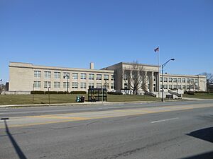
The Near East Side has several schools. There are two elementary schools: Eastgate Elementary and Beatty Park Elementary. It also has two middle schools: Champion Middle and Columbus Collegiate Academy. For high school, students attend East High School.
Historic Districts in the Near East Side
Historic districts are special areas that are protected because of their important history and unique buildings.
Columbus Near East Side District
The Columbus Near East Side District was added to the National Register of Historic Places in 1978. This means it's recognized as an important historical area in the United States.
Bryden Road District
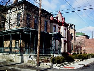
The Bryden Road District became a local historic district in 1990. This area was once called the "Silk Stocking District" because it showed off how rich and fancy the people living there were. You can find more than 50 different building styles along Bryden Road, including French, German, and Renaissance influences. The Bryden Road District runs through both the Franklin Park and Olde Towne East neighborhoods.
East Broad Street Historic District
The East Broad Street Historic District is another historic area. It was added to the National Register of Historic Places in 1987. It includes a section of East Broad Street from Ohio Avenue to Monypenny Street.
Neighborhoods in the Near East Side
Beatty Park (Mt. Vernon Avenue District)
Mount Vernon is part of the historic Near East Side. It's bordered by interstates 71 and 670. Its main roads are Mount Vernon Avenue, East Long Street, Atcheson Street, and Champion Avenue. This area is part of the Bronzeville community and used to have strong African American and Jewish communities.
Eastgate and Nelson Park
The Eastgate neighborhood was developed in 1916. It includes Nelson Park, Eastgate Elementary School, and the intersection of East Broad Street and Nelson Road. People often call this area both Eastgate and Nelson Park.
Eastwood Heights
Eastwood Heights is bordered by Taylor Avenue to the east, East Broad Street to the south, Hawthorne Avenue to the north, and Hughes Street to the west.
Franklin Park
This neighborhood is bordered by East Broad Street to the north, East Main Street to the south, and Wilson Avenue to the west.
The Alum Creek separates Franklin Park from the city of Bexley. Franklin Park is surrounded by other Near East neighborhoods like Eastgate, Nelson Park, Woodland Park, Eastwood Heights, and Bronzeville/King-Lincoln.
Hamilton Park
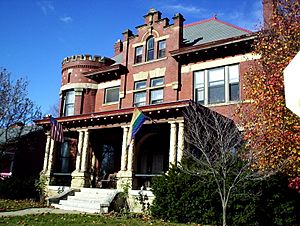
This historic neighborhood is located along Hamilton Park Avenue, between East Broad and East Long streets. It was one of four neighborhoods built around "park-like boulevards." This area was mostly African American and was popular because it was close to the railroad tracks, which offered transportation and jobs. The homes here have unique designs, like round towers and tall chimneys.
Hanford Village
Hanford Village is listed on the National Register of Historic Places. It started as a village in 1909 and became part of Columbus in 1955. Hanford was promoted to African American veterans. However, much of the neighborhood was changed in the 1960s when I-70 was built.
Holtzman-Main
This area is located between Nelson Road and the west side of Alum Creek, within the Franklin Park Neighborhood. It used to be an industrial area with simple buildings and narrow streets. Today, it's mainly commercial, with businesses like day care centers, car repair shops, and fast food. There are plans to improve the look of this area and make it a welcoming entrance to the Franklin Park neighborhood.
King-Lincoln Bronzeville
This area is just east of Downtown Columbus. It's bordered by the Mount Vernon neighborhood to the north, North 20th Street to the east, Olde Towne East and East Broad Street to the south, and Interstate 71 to the west. This area used to be much larger. When I-71 was built, it cut off the area from downtown, which caused some challenges. The neighborhood is now a focus for the city's efforts to bring new life to the area. This includes fixing up the historic Lincoln Theatre and building new homes and shops.
Old Oaks
Old Oaks is a historic neighborhood that started growing when streetcar service became electric in 1891. It was named a historic neighborhood in 1986.
Olde Towne East
Olde Towne East is a neighborhood in the historic Near East Side. It's one of Columbus's largest and oldest neighborhoods. It's located between Downtown, Bexley, Old Oaks, and South of Main. The area has over 1,000 homes, some as old as the 1830s. You can see more than 50 different architectural styles here, including Italianate, Queen Anne, and Victorian styles.
South of Main
South of Main is a neighborhood in the Near East Side. It's bordered by Main Street to the north, Interstate 70 to the south, Alum Creek to the east, and Wilson Avenue to the west. Hanford Village was once part of this area before I-70 was built in the 1950s. A unique landmark in the northeastern part of the neighborhood is a group of silos that used to store grain.
Woodland Park
This area is bordered by Maryland Avenue to the north, Nelson Road to the east, East Broad Street to the south, and Taylor Avenue to the west. The Woodland Park neighborhood has a mix of beautiful homes with many different architectural styles. These include Colonial, Federal, Arts and Crafts, Victorian, and more. This variety of homes makes Woodland Park a comfortable and attractive place to live.
Structures and Landmarks in the Near East Side
The Near East Side has over 1,000 unique homes with at least 50 different architectural styles. The Bryden Road and Broad Street areas used to have some of the richest citizens and the most grand homes.
- East High School – located on E Broad Street, built in 1922. It's an important landmark for African American communities in Columbus. A famous Ohio State football player, Chic Harley, graduated from here.
- Spring Street YMCA / Ward Home and Storage Facilities – founded in 1919. This was one of the first places to specifically serve the Black community. The E.E. Ward Moving Company is the oldest African American owned and operated business in the country that is still running today.
- Lincoln Theatre – located on Long Street, opened in 1929 by Al Jackson.
- Macon Hotel – located in the Bronzeville area, this hotel is a cultural landmark from the 1930s jazz club scene of the Near East Side. Its importance changed after I-70 was built, as it became separated from the rest of the neighborhood.
- Ohio School for the Blind – Columbus was home to the first publicly supported school for the blind in the United States. A second building was built at Parsons and Main Street. It is now the Columbus Department of Health building.
- Poindexter Village / "Blackberry Patch" – This area was originally a place for African Americans to settle after moving from the Great Migration. It was a shantytown with homes made from scrap wood. In 1941, President Roosevelt dedicated the nation's first public housing complex here, called Poindexter Village.
- Pythian Temple and James Pythian Theater – located on Mt. Vernon Avenue. It is now part of The King Arts Complex since 1987. The theater was built by the Pythian Temple Society and opened on January 10, 1926. The architect, Samuel Plato, was one of the first African-American architects to design a building in Columbus. The building is in the Colonial Revival style and was added to the National Register of Historic Places in 1983.
- Urban Cultural Arts Foundation – started in 1978, and is the oldest Black-owned art gallery in Columbus.
Parks in the Near East Side
There are twelve parks in the Near East Side, covering 165 acres.
Academy Park
Located on South Nelson Road next to Wolf Park, Academy Park has baseball fields, soccer fields, basketball courts, a walking trail, and open green space. There's also an indoor recreation center for sports.
Beatty Park
Located on North Ohio Avenue, Beatty Park has an indoor recreation center, outdoor playground equipment, basketball courts, well-lit tennis courts, and green space for family fun.
Blackburn Park
Located on Carpenter Street, this park has a sprayground (a water play area), basketball courts, green space, tennis courts, playground equipment, an indoor recreation center, and picnic areas for families.
English Park/Kwanzaa Playground
English Park was named after the English family who lived there. It's now home to the Kwanzaa Playground, which was built in 1995 by the community and the City of Columbus. Seven local artists helped design and build it. The park has a human-like shape. The playground was updated in 2015. The park focuses on positive African-American images to share the idea that "It takes a whole village to raise a child."
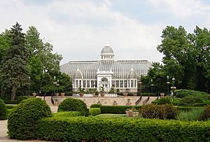
Franklin Park Conservatory
The Franklin Park Conservatory is a botanical garden and conservatory in Columbus, Ohio. It's open every day, and you need to pay to get in. It was first built in 1895 and is on the National Register of Historic Places. Today, it's a place to see amazing plant collections, special exhibits, and artworks by Dale Chihuly.
Hanford Village Park
Located on Alum Creek Drive, this small community park has basketball courts, a playground, and picnic and green space for families.
Linwood Park
Located on Linwood Avenue, this is a "pocket park" which means it's a small park. It has a paved path and benches. The community helps take care of this park.
"Pumphouse" Park
Located on East Main Street, this park used to be called Main-Alum Park. It's where a water pumping station for Columbus is located. It was also once the site of the Norwood Amusement Park. The park has open shelters, access to a greenway trail, and sports fields for family activities.
Mayme Moore Park
Located on Martin Luther King Jr. Boulevard, this park has the Amos Lynch Plaza, which is used by the King Arts Complex. It's a place for community gatherings, activities, and celebrations. The park also has a gazebo called the Beatty Pavilion. It features a playground, green space, and picnic areas for families.
Nelson Park
Located on Nelson Road, this park was given to the City of Columbus in memory of David Nelson in 1911. It's about 30 acres and has sports fields, basketball courts, greenway trail access, picnic areas, a playground, a shelter, and well-lit walking trails. It also has woods and wildlife areas.
Saunders Park
Located on Atcheson Street, this park was formerly called Maryland Park and opened in 1921. The first public swimming pool in Columbus was built here in 1929 with help from The Columbus Dispatch newspaper. The park was renamed in 1989 to honor "Eddie" Saunders, a local African American radio personality. This 14.5-acre park has sports fields, baseball diamonds, basketball courts, picnic areas, a playground, and swimming pools.
Sawyer Park
Located on Atcheson Street, this park has a community center for children and older adults to enjoy family-friendly activities. It also has picnic space, tennis courts, and a walking trail.
Near East Area Commission
The Near East Area Commission was started in 1979. Its job is to speak up for and help the people who live and work in the Near East Side.
 | Sharif Bey |
 | Hale Woodruff |
 | Richmond Barthé |
 | Purvis Young |


