Neighborhoods in Saint Paul, Minnesota facts for kids
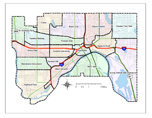
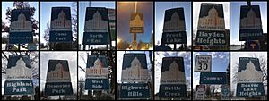
Saint Paul, Minnesota, is a city made up of 17 official areas called city districts or neighborhoods. People sometimes say it feels like "fifteen small towns with one mayor." This is because many people in Saint Paul live their lives based around their local neighborhood.
For example, the East Side of Saint Paul has many well-known, historic neighborhoods. District 4 has three old neighborhoods: Dayton's Bluff, Swede Hollow, and Mounds Park. The biggest districts, District 2 and District 5, have more than twelve neighborhoods combined.
Saint Paul is known for its active citizens. However, some neighborhoods get more attention for planning than others. This is because money from the city is given to volunteer neighborhood groups called District Councils. These groups are chosen each year and get money based on the city district boundaries, not individual neighborhood boundaries.
The District Council system started in 1975. It was created to help people get involved in their local communities. These councils also helped spend money from federal programs. The city of Saint Paul gives the District Councils about $1.2 million in total. In 2015, each council received between $51,873 and $109,475. The councils also get money from other sources, like grants and donations. Most councils have a lot of say in how land in their area is used.
Besides giving advice to city leaders about new buildings and projects, district councils also find out what their neighborhoods need. They start community programs and help find and train local leaders and volunteers.
Many of Saint Paul's neighborhoods first grew as places where people lived and took trains to work. These include Merriam Park, St. Anthony Park, Macalester Park, Desnoyer Park, Hazel Park, Union Park, Warrendale, and Burlington Heights. Burlington Heights was south of downtown, near the Burlington train tracks. It even had two train stations. You can still see parts of this old development from the 1880s.
Contents
- Saint Paul's District Councils
- District 1 - Eastview, Conway, Battle Creek, Highwood Hills
- District 2 - Greater East Side
- District 3 - West Side
- District 4 - Dayton's Bluff
- District 5 - Payne-Phalen
- District 6 - North End
- District 7 - Frogtown (Thomas-Dale)
- District 8 - Summit-University
- District 9 - West Seventh/Fort Road
- District 10 - Como Park
- District 11 - Hamline Midway
- District 12 - Saint Anthony Park
- District 13 - Union Park
- District 14 - Macalester-Groveland
- District 15 - Highland Park
- District 16 - Summit Hill
- District 17 - Downtown
Saint Paul's District Councils
District 1 - Eastview, Conway, Battle Creek, Highwood Hills
These four neighborhoods are in the southeast part of Saint Paul. They are mostly places where people live. They are different in terms of money, land, and cultures. You can find single-family homes with big yards and also many apartment buildings here. Parks in this area look out over the Mississippi River and Pig's Eye Lake. The riverfront here is an active part of Saint Paul's working river.
District 2 - Greater East Side
The Greater East Side is one of Saint Paul's biggest and most populated districts. It is also very diverse. It is in the northeast corner of the city. Its borders are the city limits to the north and east, Minnehaha Avenue to the south, and Johnson Parkway to the west. This district includes neighborhoods like Frost Lake, Hillcrest, Prosperity Heights, Hayden Heights, Beaver Lake, Hazel Park, and Phalen Village. These areas were built for people who worked in the industries further south, like 3M and Hamm’s. Today, they still have homes for people who commute, along with shops and services on White Bear Avenue and in Phalen Village.
District 3 - West Side
The West Side is actually south of Downtown Saint Paul and across the Mississippi River. It's called the West Side because it's on the west bank of the river, which mostly flows north to south here. It is next to the cities of South St. Paul and West St. Paul. The West Side is home to one of the largest Hispanic communities in the Twin Cities. This community is centered along César Chávez Street.
District 4 - Dayton's Bluff
Dayton's Bluff is on the east side of the Mississippi River in southeastern Saint Paul. It has homes on a high, flat area that looks over the Mississippi River Valley. The name comes from Lyman Dayton, an important person from the 1800s. People started buying land here as early as the 1850s for the river views. Most of the houses were built in the 1880s. On the highest part of Dayton's Bluff, along the river, is Indian Mounds Park. This park has six old burial mounds from the Hopewell people, who lived long ago. Dayton's Bluff has been updated and restored a lot in recent years.
District 5 - Payne-Phalen
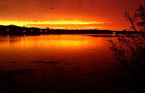
The Payne-Phalen city district includes neighborhoods like Railroad Island, Phalen Park, Rivoli Bluff, Vento, Wheelock Park, and Williams Hill. It ranges from areas with working families in the south to middle-class areas north of Maryland Avenue. This includes nicer homes around Lake Phalen. The neighborhood was first bought by three Southern landowners. They named the streets after flowers from their home, such as Hawthorn, Hyacinth, and Magnolia.
District 6 - North End
The North End is one of Saint Paul’s largest areas for homes. It has many businesses, schools, churches, and parks. The southern part of the neighborhood was built in the 1870s and 1880s, with Victorian-style homes on narrow lots. The northern half was developed later, in the 1920s or after. The main shopping street is Rice Street, named after a famous Minnesota politician. It became a busy area in the late 1890s when streetcars arrived.
The North End has many parks, including Marydale Park and the Front Avenue Skate Park. It also has many schools. Important politicians are buried at Oakland Cemetery here. The North End is also the start of the Gateway Trail. The Trout Brook Nature Sanctuary and Reserve is on its eastern border. The Willow Reserve is a 5.5-acre wetland that is home to many kinds of birds. The North End has a rich history from the 1800s and also welcomes new cultures. It is home to the largest group of Karen and Karenni immigrants from Burma.
District 7 - Frogtown (Thomas-Dale)
Frogtown, also known as Thomas-Dale, is built around University Avenue. People often call the whole area Frogtown. Historically, Frogtown was a smaller part of the Thomas-Dale neighborhood. It was bordered by University Avenue to the south, Van Buren Avenue to the north, Dale Street to the west, and Western Avenue to the east.
District 8 - Summit-University
Summit-University is a community with many different cultures and income levels. It is west of Downtown Saint Paul. It includes the historic Cathedral Hill neighborhood. It also has what is left of "old Rondo," a former neighborhood. Many groups live in Summit-University, including the Hmong community and other Asian communities, such as Vietnamese, Laotians, and Cambodians.
In the 1880s, the southern part near Summit Avenue was the most popular place to live. Homes further north, closer to University Avenue, were not as grand. Parts of the neighborhood changed a lot after the 1960s. The Rondo neighborhood was changed to make way for Interstate 94. Some areas north of Interstate 94 were rebuilt to look more like suburbs. This created a big difference between them and the older homes from the late 1800s and early 1900s near Ramsey Hill.
District 9 - West Seventh/Fort Road
West Seventh in Saint Paul is also called Fort Road. This is because it is located on old Native American and fur trader paths. These paths ran along the northern bank of the Mississippi River from downtown Saint Paul to Fort Snelling. People often call this area the "West End." It is different from the "West Side," which is across the river. The West Seventh neighborhood started as a series of European immigrant neighborhoods along the western bluffs of the Mississippi River. During the 1880s, many Irish, German, Czech, Slovak, and Scandinavian immigrants moved to the West End.
Saint Paul has a long history of active and unique neighborhoods. To help people get involved in local government, the district council planning process was created over 30 years ago. There are 17 district councils. The West End's district council is the Fort Road Federation/District 9 Community Council. These councils help plan and advise on how their areas grow physically, economically, and socially. They also find needs, start community programs, find volunteers, and hold community events. The Federation actually started before the official District Council system in Saint Paul. In 1973, a group of about a dozen community members created the West 7th/Fort Road Federation. They believed that citizens working together could keep and improve the quality of life in their neighborhoods. They also wanted to help businesses succeed again.
Today, several groups and task forces help the neighborhoods in the West End. These include the West End Gardeners and the North High Bridge Park Task Forces. There is also the West Seventh Business Association, the Irvine Park Historic District and Association, and the Czech and Slovak Sokol Minnesota in its historic hall. The West 7th Community Center also serves the area.
District 10 - Como Park
Como Park is a neighborhood built around Como Lake. The Como Park neighborhood has many fun places, including a golf course, a bike path, open fields, a pavilion, a public swimming pool, and the Como Zoo. The Como Zoo is one of two zoos in the Twin Cities. The Como area is also home to many ginkgo trees. There are several schools in Como Park. Chelsea Heights Elementary School and Como Park Elementary School are public schools here. Como Park Elementary is the only school in the city with its own planetarium. The main high school in Como Park is Como Park Senior High School. It is one of the highest-rated schools in the state.
District 11 - Hamline Midway
Hamline-Midway gets its name from being halfway between the downtown areas of Minneapolis and Saint Paul. The neighborhood includes Hamline University, Allianz Field, Ax-Man Surplus, and the Turf Club. Famous people who grew up in Midway include Charles M. Schulz, who created the Peanuts comic strip, and the band Heiruspecs.
District 12 - Saint Anthony Park
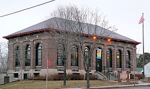
Saint Anthony Park, known as SAP by people who live there, is next to the University of Minnesota Saint Paul campus. It borders Northeast Minneapolis to the west and the Minnesota State Fairgrounds to the east. Three Minnesota governors lived here. In the late 1800s, the area was planned for wealthy families from Minneapolis. It is in the center of the Twin Cities. It has a business area with local shops and restaurants. A Carnegie Library and St. Anthony Park Elementary School are important places in the neighborhood. SAP also has two colleges, the University of Minnesota's St. Paul campus and Luther Seminary. Because of this, it is home to graduate students from all over the world. The area's largest park is named after Nathaniel P. Langford, who helped create the world's first national park, Yellowstone.
District 13 - Union Park
Union Park was formed by combining three older district councils: Merriam Park, Snelling Hamline, and Lexington-Hamline. It is a neighborhood with many homes built in the early 1900s. It has unique shops on Selby, Cretin, and Cleveland avenues. The Mississippi National River and Recreation Area forms the western border of the neighborhood. Many people in Union Park still use the original names for their specific areas. Concordia University and part of the University of St. Thomas are in this district.
- Lexington-Hamline: The Lex-Ham neighborhood is bordered by University Avenue, Lexington Parkway, and Summit and Hamline Avenues. The Lexington-Hamline Community Council started in 1969. It was Saint Paul's first neighborhood organization. It continues to be a key group for helping people in this neighborhood.
- Snelling Hamline: This area is between Snelling and Hamline Avenues, and bordered by University and Summit Avenues. The Snelling-Hamline neighborhood has its own unique feel. It is home to the old O’Gara’s Bar and Grill. It also has the new Vintage development at the corner of Snelling and Selby Avenues. This area includes "Midway Center," which is a main shopping area in inner-city Saint Paul.
- Merriam Park: This area makes up a large part of Union Park. Merriam Park is west of Snelling Avenue and stretches to the park named after it. Merriam Park was one of the first suburbs of the Twin Cities. It was a couple of trolley stops outside of early Saint Paul. A businessman named John L. Merriam thought it would be a perfect suburb for business people and their families. New streetcar lines were being built through the neighborhood. By 1880, a railroad line connecting the two downtowns also ran through the area. Merriam bought land, built a train station in his future neighborhood, and started selling lots to people who wanted to build homes.
District 14 - Macalester-Groveland
Macalester-Groveland, sometimes called Mac-Groveland, is a well-developed neighborhood in western Saint Paul. It goes east from the Mississippi River to the Summit Hill neighborhood. The neighborhood has a mix of single-family homes and apartments, with small shops and main commercial streets. The Summit Avenue Historic District, with its large homes from the late 1800s, is along the northern border of the neighborhood. In recent years, Grand Avenue has become a well-known shopping street. It has both national stores and local shops. Several colleges and universities, including the University of St. Thomas and Macalester College, are in the neighborhood. The presence of these schools means there are many cultural, athletic, and musical events for people living here. Beautiful walking and biking trails run through Mac-Groveland, especially along the Mississippi riverfront.
District 15 - Highland Park
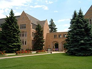
Highland Park is home to St. Catherine University. It also has two private schools, Cretin-Derham Hall High School and St. Paul Academy and Summit School. For 85 years, the neighborhood had the Ford Motor Company Twin Cities Assembly Plant. This plant made Ford Ranger and Mazda B-Series pickup trucks. Ford closed the plant in 2011. The 122 acres of land along the Mississippi River are now being developed into a mix of homes and businesses. In 2018, a company called The Ryan Companies won the right to develop the property. They will follow a plan created by the city of St. Paul.
District 16 - Summit Hill
Summit Hill is bordered by Summit Avenue and Ramsey Street to the north, Interstate 35E to the south and east, and Ayd Mill Road to the west. It is one of Saint Paul's oldest and most popular neighborhoods. Summit Hill is a special place with a lot of history, interesting buildings, unique shops and restaurants, and strong community ties. In the 1880s and 1890s, the Crocus Hill and Grand Hill neighborhoods, which are parts of Summit Hill, became popular places for wealthy families. At that time, many older homes on Summit Avenue were updated or torn down to build more fashionable houses. Early railroad and lumber leaders built homes on Summit Avenue and nearby areas.
Summit Avenue was designed to be a grand street with large homes. It is lined with mansions named after important Saint Paul figures, like the railroad leader James J. Hill. With its views of downtown and the Mississippi River, Summit Avenue is thought to be one of the longest streets with preserved Victorian mansions in North America. It has been home to artists like F. Scott Fitzgerald and Zelda Fitzgerald, Sinclair Lewis, August Wilson, and Garrison Keillor.
District 17 - Downtown
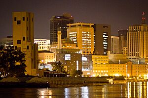
Downtown Saint Paul is home to the Xcel Energy Center, where the Minnesota Wild hockey team plays. It also has Cray Plaza across from Mears Park, and Wells Fargo Place. Downtown has several parks, with Rice Park being one of the oldest parks in the country. The street life has been getting better in some parts of downtown. This includes the bars and restaurants around Mears Park, and along Wabasha and St. Peter Streets, where several restaurants have opened. Downtown also has an extensive skyway system that connects most of the office buildings. This system allows people to walk indoors between buildings.
 | Audre Lorde |
 | John Berry Meachum |
 | Ferdinand Lee Barnett |


