North–South Corridor, Singapore facts for kids
Quick facts for kids North–South CorridorKoridor Utara-Selatan 南北运输走廊 வடக்கு-தெற்கு போக்குவரத்து தாழ்வாரம் |
|
|---|---|

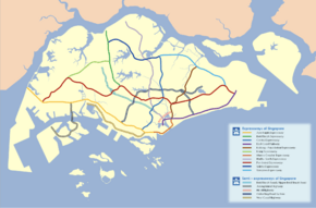
North - South Expressway is labelled in single violet line
|
|
| Route information | |
| Length | 21.5 km (13.4 mi) |
| History | Construction began in 2018, completion in 2026 |
| Major junctions | |
| North end | Admiralty Road West |
| South end | ECP, Republic Avenue and Nicoll Highway |
| Highway system | |
| Expressways of Singapore | |
The North–South Corridor (NSC) is a major new road project in Singapore. It was first called the North-South Expressway. When it is finished, it will be Singapore's 11th expressway.
The NSC will help reduce traffic on the Central Expressway (CTE). This is because many cars use the CTE to travel between the north and south of Singapore. The idea for the NSC was first announced on January 30, 2008. This happened during a big review of Singapore's transport system by the Land Transport Authority (LTA).
The NSC will be about 21 kilometres (13 mi) long. It is expected to cost billions of dollars to build. The project is planned to be finished in 2026. It will connect the East Coast Parkway (ECP) in the south to the northern parts of Singapore.
The NSC will have 16 entry points and 17 exit points. These will connect towns like Woodlands, Sembawang, Yishun, Ang Mo Kio, Bishan, and Toa Payoh to the city centre. It will also link up with other expressways like the Seletar Expressway (SLE), Pan-Island Expressway (PIE), and East Coast Parkway (ECP).
The LTA says that special bus lanes on the NSC will make bus travel much faster. Buses from Woodlands, Sembawang, Yishun, and Ang Mo Kio could reach the city up to 30 minutes faster. This will happen during busy morning and evening times. Buses will use special ramps and lanes on the NSC to speed up their journeys.
There will also be a cycling path along the entire length of the NSC. This path will connect to existing cycling networks in towns and to the city centre. This makes it easier for people to cycle safely.
The NSC was first supposed to be ready by 2023. However, due to some delays in construction, it is now expected to be completed in 2026.
Building the North-South Corridor
On January 19, 2011, the government officially approved the building of the expressway. It was planned to run between Admiralty Road West and Toa Payoh Rise. Later, on November 15, 2011, the Land Transport Authority (LTA) showed the full path of the North-South Corridor.
At first, the NSC was planned only as a road for cars, meant to be ready by 2020. But plans changed! The NSC will now be Singapore's first "integrated transport corridor." This means it will have special bus routes and a cycling path along its entire length.
Construction was supposed to start in 2017 and finish by 2023. However, the first building contract was only given out in November 2017. Actual construction work began in early 2018. The project is now planned to be finished by 2026.
Where the NSC Will Go
The NSC will start in the north of Singapore, at Admiralty Road West. It will then head south, passing through areas like Woodlands and Sembawang. It will have a connection point with the Seletar Expressway (SLE).
After that, it will go through Toa Payoh. For part of its journey, it will run right next to the Central Expressway (CTE). Finally, it will join the East Coast Parkway (ECP) in the city area.
The LTA tried to use land that already belonged to the government as much as possible. This helped to avoid taking over private buildings. Even though a large part of the NSC will be underground in the southern area, some land still had to be used. This was partly because of existing MRT train tunnels that were in the way.
Because of the NSC's path, a building called Rochor Centre had to be taken down. Some underground passages at Novena Square also had to be removed. Another building, the Ellison Building, might also need to be taken down.
 | Kyle Baker |
 | Joseph Yoakum |
 | Laura Wheeler Waring |
 | Henry Ossawa Tanner |

