North Koolaupoko, Hawaii facts for kids
Quick facts for kids
Waikāne
North Koʻolaupoko
|
|
|---|---|

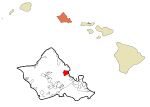
Location in Honolulu County and the state of Hawaii
|
|
| Country | United States |
| State | Hawaii |
| County | Honolulu |
| Area | |
| • Total | 7.2 sq mi (18.6 km2) |
| • Land | 6.8 sq mi (17.7 km2) |
| • Water | 0.3 sq mi (0.9 km2) |
| Elevation | 46 ft (14 m) |
| Population
(2010)
|
|
| • Total | 778 |
| • Density | 108.3/sq mi (41.83/km2) |
Waikāne (pronounced vai-KAH-neh), also known as North Koʻolaupoko, is a special area in Hawaii. It's a place called a census-designated place (CDP). This means it's an area that the government counts for population, but it's not an official city or town. Waikāne is located in Honolulu County on the island of Oʻahu. In 2010, about 778 people lived there.
The name Koʻolaupoko means "short windward" in the Hawaiian language. This describes its location on the side of the island that gets a lot of wind and rain. It's the shorter of the two "windward" areas on Oʻahu. The other one is Koʻolauloa, which means "long windward". Koʻolaupoko stretches from Makapuʻu Point in the southeast to Kaʻōʻio Point in the north. Some bigger towns like Kāneʻohe and Kailua are also in this district, but they are south of Waikāne.
Waikāne is mostly found along the coast of Kāneʻohe Bay. It has many green, lush valleys that reach inland towards the tall Koʻolau pali, which means "cliffs". The valleys here include Waiāhole, Waikāne, Hakipuʻu, and Kualoa. This area is different from the busier towns to the south. It's mostly undeveloped and feels very rural, with many small farms.

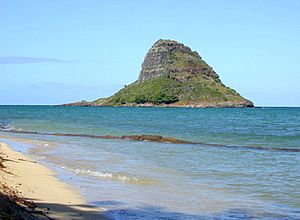
Even though Waikāne has a long coastline, it can be a bit tricky to get to the bay because much of the land is privately owned. There's a small community park at Waiāhole that was made better in 2003. Also, Kualoa Regional Park is a larger park where people can camp, have picnics, and enjoy a narrow beach. From Kualoa Park, you can see the beautiful Mokoliʻi Islet. The park's south side faces Kāneʻohe Bay, and its east side has a reef facing the Pacific Ocean.
The postal code for all of North Koʻolaupoko, including Waikāne, is 96744.
Exploring Waikāne's Location
The Waikāne census-designated place (CDP) is found at coordinates 21°29'47" North and 157°51'34" West. If you travel south along the coast of Kāneʻohe Bay on Kamehameha Highway (State Route 83), you'll find Waiāhole and Kahaluʻu. Heading northwest up the coast, past Kualoa and Kaʻōʻio Point, you'll reach the town of Kaʻaʻawa.
The Waikāne CDP covers a larger area than just the specific valley called Waikāne. It includes several valleys that make up the northern part of the Koʻolaupoko District. The total area of the CDP is about 18.6 square kilometers (7.2 square miles). Most of this area, about 17.7 square kilometers (6.8 square miles), is land, and 0.9 square kilometers (0.35 square miles) is water. This means that about 4.88% of the total area is water.
People Who Live in Waikāne
In the year 2000, there were 726 people living in the northern part of the Waikāne CDP. These people lived in 188 households, and 156 of these were families. The area had about 106 people per square mile.
The people living in Waikāne come from many different backgrounds. Here's a look at the different groups:
- About 17% were White.
- About 19% were Asian.
- About 22% were Pacific Islander.
- About 39% were from two or more racial backgrounds.
- A small number were Black or Native American.
- About 5% of the population identified as Hispanic or Latino.
Many households in Waikāne had children under 18 living with them (about 32%). Most households were married couples living together (about 59%). The average household had about 3.86 people, and the average family had about 4.09 people.
The population of Waikāne includes people of all ages:
- About 28% were under 18 years old.
- About 8% were between 18 and 24 years old.
- About 27% were between 25 and 44 years old.
- About 27% were between 45 and 64 years old.
- About 9.5% were 65 years old or older.
The average age of people in Waikāne was 34 years.
Learning in Waikāne
The Hawaii Department of Education is in charge of the schools in Hawaii. They operate Waiāhole Elementary School, which is located within the Waikāne CDP. This school helps educate the younger students in the area.
See also
 In Spanish: North Koolaupoko (Hawái) para niños
 | Jewel Prestage |
 | Ella Baker |
 | Fannie Lou Hamer |

