kids encyclopedia robot

Operation Touchstone facts for kids

Kids Encyclopedia Facts
Quick facts for kids
Touchstone
Information
Country United States
Period 1987–1988
Number of tests 13
Test type underground shaft, tunnel
Max. yield 150 kilotonnes of TNT (630 TJ)
Touchstone Kearsarge 001
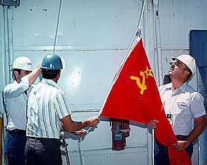
A Soviet flag is raised next to an American flag at the Nevada Test Site as part of the Joint Verification Experiment

The United States's Touchstone nuclear test series was a group of 13 nuclear tests conducted in 1987–1988. These tests followed the Operation Musketeer series and preceded the Operation Cornerstone series.

The series included Touchstone Kearsarge, a joint US-Soviet test as part of the Joint Verification Experiment (JVE). The JVE's purpose was to provide yield data to both parties about each other's nuclear test sites so that accurate remote measurements could be taken to verify each other's compliance with the Threshold Test Ban Treaty.

List of the nuclear tests

United States' Touchstone series tests and detonations
Name Date time (UT) Local time zone Location Elevation + height Delivery
Purpose
Device Yield Fallout References Notes
Borate October 23, 1987 16:00:00.09 PST (–8 hrs)
NTS Area U2ge 37°08′31″N 116°04′46″W / 37.14185°N 116.07957°W / 37.14185; -116.07957 (Borate) 1,294 m (4,245 ft) – 542.5 m (1,780 ft) underground shaft,
weapons development
38 kt I-131 venting detected, 0
Waco December 1, 1987 16:30:00.09 PST (–8 hrs)
NTS Area U3lu 36°59′47″N 116°00′19″W / 36.99636°N 116.00533°W / 36.99636; -116.00533 (Waco) 1,176 m (3,858 ft) – 182.9 m (600 ft) underground shaft,
weapons development
less than 20 kt
Mission Cyber December 2, 1987 16:00:00.084 PST (–8 hrs)
NTS Area U12p.02 37°14′05″N 116°09′51″W / 37.2346°N 116.16425°W / 37.2346; -116.16425 (Mission Cyber) 1,926 m (6,319 ft) – 270.6 m (888 ft) tunnel,
weapon effect
2 kt
Kernville February 15, 1988 18:10:00.089 PST (–8 hrs)
NTS Area U20ar 37°18′52″N 116°28′21″W / 37.31431°N 116.47253°W / 37.31431; -116.47253 (Kernville) 1,899 m (6,230 ft) – 541.6 m (1,777 ft) underground shaft,
weapons development
60 kt
Abilene April 7, 1988 17:15:00.078 PST (–8 hrs)
NTS Area U3mn 37°00′47″N 116°02′43″W / 37.01311°N 116.04519°W / 37.01311; -116.04519 (Abilene) 1,187 m (3,894 ft) – 245.06 m (804.0 ft) underground shaft,
weapons development
2 kt
Schellbourne May 13, 1988 15:35:00.108 PST (–8 hrs)
NTS Area U2gf 37°07′28″N 116°04′23″W / 37.12439°N 116.073°W / 37.12439; -116.073 (Schellbourne) 1,268 m (4,160 ft) – 463 m (1,519 ft) underground shaft,
weapons development
16 kt Venting detected, 22 Ci (810 GBq)
Laredo May 21, 1988 22:30:00.14 PST (–8 hrs)
NTS Area U3mh 37°01′57″N 115°59′17″W / 37.03245°N 115.98814°W / 37.03245; -115.98814 (Laredo) 1,220 m (4,000 ft) – 351.4 m (1,153 ft) underground shaft,
weapons development
3.5 kt
Comstock June 2, 1988 13:00:00.088 PST (–8 hrs)
NTS Area U20ay 37°15′36″N 116°26′31″W / 37.26008°N 116.44197°W / 37.26008; -116.44197 (Comstock) 1,960 m (6,430 ft) – 620.3 m (2,035 ft) underground shaft,
weapons development
80 kt Venting detected
Nightingale - 2 (with Rhyolite) June 22, 1988 14:00:00.079 PST (–8 hrs)
NTS Area U2ey 37°09′58″N 116°04′23″W / 37.16611°N 116.07312°W / 37.16611; -116.07312 (Nightingale - 2) 1,309 m (4,295 ft) – 237.7 m (780 ft) underground shaft,
safety experiment
less than 150 kt Simultaneous, separate holes.
Rhyolite - 1 (with Nightengale) June 22, 1988 14:00:00.079 PST (–8 hrs)
NTS Area U2ey 37°09′58″N 116°04′23″W / 37.16611°N 116.07312°W / 37.16611; -116.07312 (Rhyolite - 1) 1,309 m (4,295 ft) – 207.3 m (680 ft) underground shaft,
weapons development
less than 150 kt Simultaneous, separate holes.
Alamo July 7, 1988 15:05:30.07 PST (–8 hrs)
NTS Area U19au 37°15′09″N 116°22′39″W / 37.25239°N 116.37756°W / 37.25239; -116.37756 (Alamo) 1,964 m (6,444 ft) – 622.1 m (2,041 ft) underground shaft,
weapons development
150 kt
Kearsarge August 17, 1988 17:00:00.095 PST (–8 hrs)
NTS Area U19ax 37°17′50″N 116°18′27″W / 37.2971°N 116.30742°W / 37.2971; -116.30742 (Kearsarge) 2,102 m (6,896 ft) – 615.7 m (2,020 ft) underground shaft,
weapons development
140 kt The American part of the Joint Verification Experiment.
Harlingen - 1 August 23, 1988 18:30:00.08 PST (–8 hrs)
NTS Area U6g 36°59′28″N 116°01′08″W / 36.99113°N 116.01887°W / 36.99113; -116.01887 (Harlingen - 1) 1,175 m (3,855 ft) – 289.6 m (950 ft) underground shaft,
weapons development
2 kt Simultaneous, separate holes.
Harlingen - 2 August 23, 1988 18:30:00.08 PST (–8 hrs)
NTS Area U6h 36°59′19″N 116°01′08″W / 36.98868°N 116.01876°W / 36.98868; -116.01876 (Harlingen - 2) 1,175 m (3,855 ft) + underground shaft,
weapons development
less than 20 kt Simultaneous, separate holes.
Bullfrog August 30, 1988 18:00:00.089 PST (–8 hrs)
NTS Area U4au 37°05′09″N 116°04′09″W / 37.08593°N 116.06925°W / 37.08593; -116.06925 (Bullfrog) 1,236 m (4,055 ft) – 489.2 m (1,605 ft) underground shaft,
weapons development
33 kt Venting detected, 4 Ci (150 GBq)
kids search engine
Operation Touchstone Facts for Kids. Kiddle Encyclopedia.