Ordubad District facts for kids
Quick facts for kids
Ordubad
|
|
|---|---|

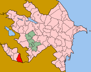
Map of Azerbaijan showing Ordubad Raion
|
|
| Country | Azerbaijan |
| Capital | Ordubad |
| Area | |
| • Total | 970 km2 (370 sq mi) |
| Population | |
| • Total | 40,600 |
| • Density | 41.86/km2 (108.4/sq mi) |
| Postal code |
AZ6900
|
| Telephone code | 0136 |
Ordubad is a special kind of administrative area, like a district or region, in Azerbaijan. It is located within the Nakhchivan Autonomous Republic, which is a part of Azerbaijan but has its own government. The main city and capital of this area is also called Ordubad. It is the second largest town in all of Nakhchivan. Besides the main city, Ordubad Raion also includes 47 other villages and smaller settlements.
The Name of Ordubad
The area of Ordubad has a very old and interesting history. Its original name was Goghtan. This name comes from a Turkic way of saying the Armenian word "Vortvat".
What "Vortvat" Means
The word "Vortvat" means "the wormy place". This might sound a bit strange! However, there's a good reason for it. The land along the Araxes River, which flows through Ordubad, used to have many special worms.
Worms for Ink
These worms were very important. People used them to make inks for printing. This shows how nature played a big role in the history and economy of Ordubad.
See also
 In Spanish: Raión de Ordubad para niños

