Pakihi Island facts for kids
|
Location in New Zealand
|
|
| Geography | |
|---|---|
| Coordinates | 36°54′29″S 175°09′50″E / 36.908°S 175.164°E |
| Administration | |
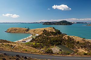
Pakihi Island is a small, privately-owned island in New Zealand. It is located in the Hauraki Gulf, which is a large body of water to the east of Auckland, a major city. Being "privately-owned" means it belongs to a family or group, not the public.
The island covers about 114 hectares (which is about 280 acres). It is one of the smaller islands in the Hauraki Gulf. Pakihi Island is found about 1 kilometer southwest of Ponui Island. It is also about 1.5 kilometers away from Waitawa Regional Park on the mainland.
What Pakihi Island Looks Like
Pakihi Island has different types of land. Much of it is used for "pastoral" activities. This means it's used for grazing animals like sheep or cattle. There are also areas with "plantations." These are places where trees have been planted, often for wood. The island also has some natural areas with native plants.
A Look Back at Pakihi Island's History
The McCallum family bought Pakihi Island in 1894. They purchased it from a famous person named Sir John Logan Campbell. They also bought a smaller island nearby called Karamuramu Island at the same time.
In 1904, William Fraser McCallum and his brothers started a business together. From 1906 to 1927, they "quarried" a type of rock called red "chert" on the island. To "quarry" means to dig out rock from the ground. Chert is a hard, strong rock. It was used a lot to make concrete buildings in Auckland as the city grew.
To help with their quarrying business, they used an old ship as a wharf. A "wharf" is a structure built out into the water where ships can dock. The ship they used was called the Rotomahana. It was the very first iron ship ever built in Auckland, made in 1876.
 | John T. Biggers |
 | Thomas Blackshear |
 | Mark Bradford |
 | Beverly Buchanan |


