
Parangalitsa Peak facts for kids


Parangalitsa Peak is a tall, rocky mountain peak in Antarctica. It stands at about 2,700 meters (that's over 8,800 feet!) high. This peak is found at the southern end of something called the Veregava Ridge. This ridge is on the eastern side of the Sentinel Range, which is part of the Ellsworth Mountains in Antarctica. Imagine a giant, icy landscape, and this peak stands out!
This peak is very important because it rises above two glaciers. To its west is the Dater Glacier, and to its east is the Hansen Glacier. Glaciers are like slow-moving rivers of ice.
The name "Parangalitsa" comes from a special place in Bulgaria. It's named after the Parangalitsa Nature Reserve, which is in the Rila Mountain in Bulgaria.
Where is Parangalitsa Peak?
Parangalitsa Peak is located in a very cold and remote part of Antarctica. Its exact spot is at 78°29′27″S, 85°00′25″W. To help you imagine where it is, it's about 4 kilometers (2.5 miles) southwest of another peak called Mount Waldron.
It's also about 3.2 kilometers (2 miles) west-northwest of Mount Tuck. A place called Manole Pass separates Parangalitsa Peak from Mount Tuck. And if you go about 6.7 kilometers (4 miles) east, you'll find Vanand Peak. Maps of this area were made by the United States in 1988.
Images for kids
-
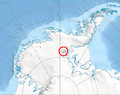
Where the Sentinel Range is located in Western Antarctica.
-
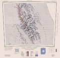
A map showing the Sentinel Range.
