Pirayú facts for kids
Quick facts for kids
Pirayú
|
|
|---|---|

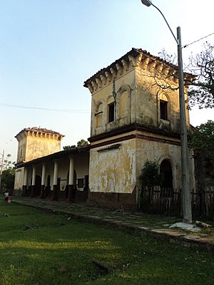
Old train station, built circa 1860
|
|
| Country | Paraguay |
| Department | Paraguarí |
| Founded | 15 October 1769 |
| Founded by | Carlos Morphi |
| Area | |
| • Total | 141 km2 (54 sq mi) |
| Population
(2016)
|
|
| • Total | 17,601 |
| • Density | 125.72/km2 (325.6/sq mi) |
| Time zone | UTC-4 |
| • Summer (DST) | UTC-3 |
Pirayú is a town in the Paraguarí department of Paraguay. It is about 50 kilometers (31 miles) from Asunción, the capital city. The town is located near the beautiful Cordillera de los Altos mountains.
Contents
A Look Back: Pirayú's History
Pirayú was once known as Gayoso Chapel. This name came from a land gift by the Gayoso family. They gave the land to the local Franciscan religious group.
The town grew around a small chapel. A simple neighborhood slowly turned into a rural parish. In 1767, a Franciscan church was built. Some parts of the church suggest it might be even older, possibly from 1561 or 1567.
After a big war, the areas around Pirayú were reorganized. This made Pirayú a part of the Paraguarí department.
Today, the main part of Pirayú has four neighborhoods, called Barrios No. 1 to 4. It also includes twelve larger areas known as Companies. These are Paso Esperanza, Tuyucuá, Taba i, Potrero Avendaño, Costa Hũ, Cerro Verá, Azcurra, Ykuá Kaũ, Arroyo Servin, Yaguarón Yurú, Cerro León, and Ka'aguy Potî.
The town area has homes and a railway station built in 1864. There are also newer buildings. The countryside has farms and is crossed by natural streams.
Where is Pirayú? (Geography)
The district of Pirayú is in the northern part of the Paraguarí Department. This area has many hills. These hills are part of the Highlands mountain range.
Some of the hills in the region are Yvytypané, Mbatoví, and Santo Tomás. Pirayú covers an area of 141 square kilometers (54 square miles).
To the north, Pirayú shares a border with the Cordillera Department. To the west, it borders the Central Department. To the south, it is next to Yaguarón and Paraguarí. To the east, it again borders the Cordillera Department.
Several streams flow through the Pirayú district. The main one is the Pirayú stream. Other streams include Peña, Poti'y, Madame Linch, Ramírez, and Zorrilla.
What People Do in Pirayú (Economy)
The main activities in Pirayú include making crafts. People create beautiful fabrics like Ñandutí, which are traditional lace. They also make hammocks and shoes.
Farming is another important activity. Farmers grow sweet cane, cassava (a root vegetable), and seasonal fruits. Raising animals is also common, especially cattle.
The region also has many quarries. These are places where people dig up materials from the ground. They extract brick, clay, and kaolin, which is a type of white clay.
Getting Around and Staying Connected
The main roads for travel by land are Route PY01 and Route PY02. These roads help people move around the district.
For communication, the state company COPACO provides telephone services. Mobile phone services are also available. People can also use public buses to travel. There are local radio stations and cable television channels too.
You can reach Pirayú by a road that branches off Route PY01 at kilometer 48, near Yaguarón. Another way to get there is from Route PY02 at kilometer 36, in the city of Ypacarai. These roads connect Pirayú to Asunción, the country's capital, and to other towns in the district.
See also
 In Spanish: Pirayú (Paraguay) para niños
 | Victor J. Glover |
 | Yvonne Cagle |
 | Jeanette Epps |
 | Bernard A. Harris Jr. |


