Pueblo Nuevo Solistahuacán facts for kids
Quick facts for kids
Pueblo Nuevo Solistahuacán
|
|
|---|---|
 |
|
| Country | |
| State | Chiapas |
| Area | |
| • Total | 419.8 km2 (162.1 sq mi) |
| Population
(2010)
|
|
| • Total | 31,075 |
| Postal code |
29750
|
| Area code(s) | 919 |
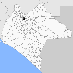
Pueblo Nuevo Solistahuacán is a town and a type of local government area called a municipality. It is located in the state of Chiapas in southern Mexico.
Contents
About Pueblo Nuevo Solistahuacán
Pueblo Nuevo Solistahuacán is both a town and a larger region around it. This region is known as a municipality. It is found in the southern part of Mexico.
Population and Size
In 2010, the whole municipality had about 31,075 people living there. This was more than the 24,405 people counted in 2005. The total area of the municipality is about 419.8 square kilometers.
The main town of Pueblo Nuevo Solistahuacán had a population of 10,043 people in 2010. The municipality also has many smaller communities. Some of the larger ones included Rincón Chamula (5,592 people) and San José Chapayal (2,059 people).
Changes to the Municipality
After 2010, the size and population of the municipality changed. In 2017, the town of Rincón Chamula and its nearby communities became their own separate municipality. This new area is now called Rincón Chamula San Pedro.
Education
Pueblo Nuevo Solistahuacán is home to Universidad Linda Vista. This is a private university. It is connected with the Seventh-day Adventist Church.
See also
 In Spanish: Pueblo Nuevo Solistahuacán para niños


