Qañawimayu facts for kids
Quick facts for kids Qañawimayu |
|
|---|---|

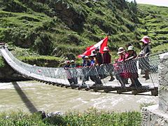
Children are waving the Peruvian flag on the new footbridge across Qañawimayu (Santo Tomás River) in Qullpatumayku, Chumbivilcas Province
|
|
| Country | Peru |
| Region | Apurímac Region, Cusco Region |
| Physical characteristics | |
| Main source | Santo Tomás District 14°48′59″S 72°22′57″W / 14.81639°S 72.38250°W |
| River mouth | Apurímac River |
The Qañawimayu is a river in Peru. Its name comes from the Quechua language. Qañawi is a type of cereal plant, and mayu means river. So, Qañawimayu means "qañawi river."
This river is special because it has many different names along its path! Upstream, it is called Cayacti. Further downstream, it becomes Jaraucata, then Qullpa (also spelled Collpa), and Yawina (also spelled Yavina). Finally, it is known as the Santo Tomás River.
The Qañawimayu flows through two important regions in Peru: the Apurímac Region (in Cotabambas Province) and the Cusco Region (in Chumbivilcas Province and Paruro Province). It is part of the larger Apurímac River system.
Contents
Where Does the Qañawimayu River Start?
The Qañawimayu river begins in the southwestern part of the Santo Tomás District. This area is in the Chumbivilcas Province of the Cusco Region.
River's Source and High Mountains
The river starts high up in the mountains. It flows between two peaks called Minasniyuq and Qullpa K'uchu. The source of the river is at a very high elevation, about 4,940 meters (16,207 feet) above sea level.
How Does the Qañawimayu River Flow?
When the Qañawimayu river first starts, it flows towards the north. As it continues its journey, it changes direction.
River's Path and Tributaries
South of a mountain called Wamanripa, the river turns and flows towards the northeast. It also gets more water from another stream called Sinqa Wayq'u, which joins it. Near the town of Santo Tomás, the river turns north again.
Where the River Ends Its Journey
The Qañawimayu river eventually joins the Apurímac River. This meeting point is at a mountain named Tinkuq (also spelled Tincoc). This spot is located where the districts of Tambobamba, Ccapi, and Huanoquite meet.
See also
 In Spanish: Río Santo Tomás para niños
 | Bessie Coleman |
 | Spann Watson |
 | Jill E. Brown |
 | Sherman W. White |

