Raivavae facts for kids
Quick facts for kids
Raivavae
|
||
|---|---|---|

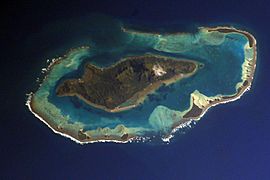
NASA picture of Raivavae island
|
||
|
||
 |
||
| Country | France | |
| Overseas collectivity | French Polynesia | |
| Subdivision | Austral Islands | |
| Area
1
|
17.9 km2 (6.9 sq mi) | |
| Population
(2017)
|
903 | |
| • Density | 50.45/km2 (130.7/sq mi) | |
| Time zone | UTC−10:00 | |
| INSEE/Postal code |
98739 /98750
|
|
| Elevation | 0–437 m (0–1,434 ft) | |
| 1 French Land Register data, which excludes lakes, ponds, glaciers > 1 km2 (0.386 sq mi or 247 acres) and river estuaries. | ||
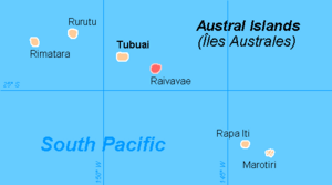
Raivavae is a beautiful island in French Polynesia. It is one of the Austral Islands. The name "Raivavae" comes from the Tahitian language.
This island is quite small. Its total land area, including tiny islands nearby, is about 17.9 square kilometers. That's roughly the size of a small town! In 2017, about 903 people lived there. Raivavae was formed by volcanoes. Its highest point is Mont Hiro, which is 437 meters tall.
Contents
History of Raivavae
First European Visitors
The first time Europeans saw Raivavae was on February 5, 1775. A Spanish naval officer named Tomás Gayangos was on a ship called El Aguila. He was leading an expedition. Another ship, the Jupiter, was with them.
On February 6, a small boat from the Spanish ships went closer to the island. They met some of the local people on the shore. However, the Europeans did not actually land on the island. The Spanish explorers called the island Santa Rosa. They also wrote down the name the people of Raivavae used, which sounded like Oraibaba to them.
Becoming Part of France
Many years later, in 1880, Raivavae became part of France. This means France took control of the island.
How Raivavae is Governed
The islands of Raivavae are part of a larger area called a "commune." A commune is like a local government area. The main island of Raivavae is the center of this commune.
The Raivavae commune includes a few smaller areas. These are called associated communes:
- Anatonu
- Rairua-Mahanatoa
- Vaiuru
See also
- In Spanish: Raivavae (isla) para niños
- Islands controlled by France in the Indian and Pacific oceans
 | Percy Lavon Julian |
 | Katherine Johnson |
 | George Washington Carver |
 | Annie Easley |


