
San Andrés de Cuerquia facts for kids
Quick facts for kids
San Andrés, Antioquia
Cuerqueño
|
|||
|---|---|---|---|
|
Municipality and town
|
|||
 |
|||
|
|||

Location of the municipality and town of San Andrés, Antioquia in the Antioquia Department of Colombia
|
|||

San Andrés, Antioquia
Location in Colombia
|
|||
| Country | Colombia | ||
| Department | Antioquia Department | ||
| Subregion | Northern | ||
| Time zone | UTC-5 (Colombia Standard Time) | ||


San Andrés is a town and municipality in the Antioquia Department of Colombia. It is located in the northern part of Antioquia. This beautiful area is known for its green mountains and coffee farms. It is sometimes called the "Little Chest Enclosed Between Mountains."
Contents
Exploring San Andrés's Past
San Andrés has a long and interesting history. It was first home to native people, including the Nutabes Indians. Their leader was a strong warrior named Cacique Guarcama.
Early Encounters and Changes
In 1574, a Spanish captain named Andrés de Valdivia arrived in the area. He tried to take control of the land. There was a conflict with Cacique Guarcama, and Valdivia was killed. The place where this happened is now called La Matanza.
After Valdivia's death, another Spanish leader, Don Gaspar de Rodas, arrived. A strong response from the Spanish kingdom followed, which greatly affected the native population.
In 1582, Don Francisco Lopez de Rúa founded a town in the Guarcama Valley. He named it San Andrés de Cauca. This name honored the captain who had died and the nearby Cauca River.
A Town Reborn
On January 25, 1793, a big fire destroyed much of the town. This made San Andrés less important for a while. However, the local church, the parish of San Andrés, had been created earlier in 1761. The town officially became a municipality in 1822.
In 1853, the town was moved to its current location. At first, it was called Cuerquia, after the local "Cuerquías" tribes. It was also known as Calcedonia and Pabón for short periods. But soon, it was officially renamed San Andrés de Cuerquia to honor its history.
The new town was founded by Presbítero Domingo Antonio Angarita, Baldomero Jaramillo Ruiz, and Pedro José Jaramillo Romero. By 1856, San Andrés de Cuerquia was officially a municipality. In the early 1900s, it became important again. This was thanks to its fertile hills, which are perfect for growing many types of crops, especially coffee.
Quick Facts About San Andrés
- Foundation Date: June 13, 1761
- Became a Municipality: 1856
- Founders of the New Town: Presbítero Domingo Antonio Angarita, Baldomero Jaramillo, and Pedro José Jaramillo
- Nickname: "Cofrecito enclosed between mountains" (Little Chest Enclosed Between Mountains)
Climate and Natural Beauty
San Andrés has a pleasant temperate climate. It is famous for its coffee production. The area is full of natural beauty, including:
- Rivers
- Streams (called quebradas)
- Waterfalls
These natural spots create beautiful landscapes. Many tourists visit to enjoy nature walks and explore the region's stunning scenery.
Population of San Andrés
As of 2015, San Andrés had a total population of 6,226 people.
- Urban Population: 2,521 people live in the main town area.
- Rural Population: 3,705 people live in the countryside villages.
Villages and Communities
The municipality of San Andrés includes many small villages. Some of these are:
- Montañadentro
- San Miguel
- La Chorrera
- Cordillera
- El Roble
- Aguacatal
- Alto Seco
- Cañaduzales
- El Cántaro
- Santa Gertrudis
- Travesías
- Loma Grande
- San Antonio
- Las Cruces
- Cruces Arriba
- La Ciénaga
- La Lejía
- Atezal
- El Vergel
- Media Loma
- Loma del Indio
- El Filo
- Montebello
- San Julián
These villages are an important part of the community and contribute to the rural charm of San Andrés.
Images for kids
-
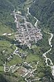
A view of the urban area of San Andrés de Cuerquia.
See also

