San Antonio District, Escazú facts for kids
Quick facts for kids
San Antonio
|
|
|---|---|
|
District
|
|

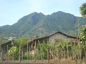
Escazú hills seen from San Antonio
|
|
| Country | |
| Province | San José |
| Canton | Escazú |
| Area | |
| • Total | 17.01 km2 (6.57 sq mi) |
| Elevation | 1,245 m (4,085 ft) |
| Population
(2011)
|
|
| • Total | 22,554 |
| • Density | 1,325.9/km2 (3,434.1/sq mi) |
| Time zone | UTC−06:00 |
| Postal code |
10202
|
San Antonio is a cool place located in Costa Rica! It's a district within the Escazú canton. This canton is part of the San José province. Think of it like a neighborhood within a bigger town, inside a larger area of the country.
Contents
Exploring San Antonio's Geography
San Antonio covers an area of about 17 square kilometers. That's like a medium-sized park! It's also quite high up, sitting at about 1,245 meters above sea level. This means it might have cooler weather than places closer to the coast.
San Antonio's Growing Population
Demographics is a fancy word for studying how many people live in a place. It also looks at how that number changes over time. San Antonio has seen its population grow a lot!
Back in 1883, only 1,770 people lived here. By 1950, the population had grown to 2,581. In 2011, a census showed that 22,554 people called San Antonio home. This shows how much the district has developed over the years.
Life in San Antonio
San Antonio is one of the higher towns in its city. It has a traditional church right in the center. Next to the church, you'll find a town square and a football field. Most of the local shops and businesses are located around this central area. It's a great spot for people to gather and enjoy their community.
Getting Around San Antonio
Road Connections
The district is connected by important roads. One of these is National Route 105. This road helps people travel in and out of San Antonio easily.
See also
 In Spanish: San Antonio (Escazú) para niños


