San Francisco River (Bogotá) facts for kids
Quick facts for kids San Francisco River |
|
|---|---|

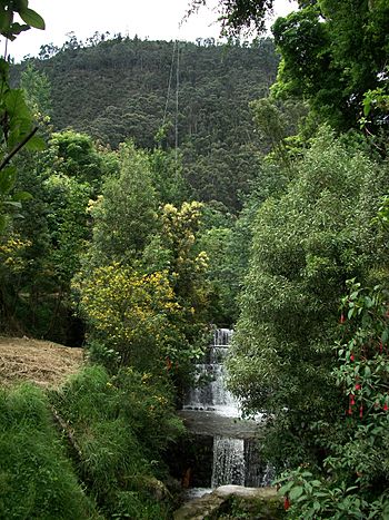
San Francisco River in Bogotá, near the Quinta de Bolívar.
|
|
| Lua error in Module:Location_map at line 420: attempt to index field 'wikibase' (a nil value).
Mouth location in Colombia
|
|
| Country | Colombia |
| Physical characteristics | |
| Main source | Páramo de Cruz Verde 2,640 m (8,660 ft) |
| River mouth | Fucha River |
| Length | 10 km (6.2 mi) |
The San Francisco River (which in Spanish is Río San Francisco) flows across the Bogotá savanna from east to west. This river is very important to the history of the city. For many years, it marked the northern edge of Bogotá when the city was first founded by colonists.
The river starts in a high mountain area called the Páramo de Cruz Verde. It then flows down from the Monserrate hill. When it reaches the city, the river goes into special channels. Near Avenida Jiménez and Sixth Street, it joins another river, the San Agustín River, but they both flow underground there.
Contents
River's Journey and History
The River's Original Name
Long ago, the native people who lived in the Bogotá savanna called this river the Vicachá River. This name means "The glow of the night." It was the biggest river in the area. For its first few centuries, the Vicachá River provided all the water for the city. It also formed the southern border of a part of the city called the parish of Las Nieves.
How the River Got Its New Name
In 1550, a religious group called the Franciscans settled near the river. They built the Church of San Francisco on the river's north bank. Because of this church, the Vicachá River started to be called the San Francisco River.
The River Today
In the 1930s, the river was put into channels, and a major street called Avenida Jiménez was built over it. This changed how the river looked in the city. However, between 1999 and 2001, a project called the Environmental Axis was created. This project helped bring back a small part of the river's original look and flow.
See also
 In Spanish: Río San Francisco (Bogotá) para niños
 | Kyle Baker |
 | Joseph Yoakum |
 | Laura Wheeler Waring |
 | Henry Ossawa Tanner |

