San Isidro, Vázquez de Coronado facts for kids
Quick facts for kids
San Isidro
|
|
|---|---|
|
District
|
|

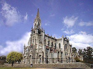
The San Isidro Labrador parish church
|
|
| Country | |
| Province | San José |
| Canton | Vázquez de Coronado |
| Area | |
| • Total | 5.14 km2 (1.98 sq mi) |
| Elevation | 1,385 m (4,544 ft) |
| Population
(2011)
|
|
| • Total | 16,625 |
| • Density | 3,234/km2 (8,377/sq mi) |
| Time zone | UTC−06:00 |
| Postal code |
11101
|
San Isidro is a district in Costa Rica. It's located in the San José area, within a larger region called the Vázquez de Coronado canton. Think of a district as a neighborhood or a smaller part of a city or county.
About the Area
San Isidro covers an area of about 5.14 square kilometers. That's like a little over two square miles. It's also quite high up, at 1,385 meters (about 4,544 feet) above sea level. This means it might have cooler weather than places closer to the coast.
Who Lives Here?
This section tells us about the people living in San Isidro. The number of people living in San Isidro has changed a lot over the years.
| Historical population | |||
|---|---|---|---|
| Census | Pop. | %± | |
| 1864 | 1,270 | — | |
| 1883 | 1,668 | 31.3% | |
| 1892 | 1,971 | 18.2% | |
| 1927 | 1,585 | −19.6% | |
| 1950 | 2,597 | 63.8% | |
| 1963 | 4,607 | 77.4% | |
| 1973 | 6,313 | 37.0% | |
| 1984 | 9,154 | 45.0% | |
| 2000 | 15,570 | 70.1% | |
| 2011 | 16,625 | 6.8% | |
|
Instituto Nacional de Estadística y Censos |
|||
According to the 2011 census, San Isidro had a population of 16,625 people. This shows how the district has grown over time.
Getting Around
Road Transportation
You can get to and from San Isidro using a few main roads. These roads help people travel within the district and to other parts of Costa Rica.
See also
 In Spanish: San Isidro (Vázquez de Coronado) para niños
 | Selma Burke |
 | Pauline Powell Burns |
 | Frederick J. Brown |
 | Robert Blackburn |


