South Canal, Ohio facts for kids
Quick facts for kids
South Canal, Ohio
|
|
|---|---|

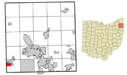
Location of South Canal in Trumbull County within the state of Ohio
|
|
| Country | United States |
| State | Ohio |
| County | Trumbull |
| Area | |
| • Total | 1.71 sq mi (4.44 km2) |
| • Land | 1.69 sq mi (4.37 km2) |
| • Water | 0.03 sq mi (0.07 km2) |
| Elevation | 932 ft (284 m) |
| Population
(2020)
|
|
| • Total | 1,101 |
| • Density | 652.25/sq mi (251.84/km2) |
| Time zone | UTC-5 (Eastern (EST)) |
| • Summer (DST) | UTC-4 (EDT) |
| FIPS code | 39-73118 |
| GNIS feature ID | 2393239 |
South Canal is a small place in Ohio, United States. It's not a city or town, but a special area called a census-designated place. This means it's a community that the government counts for population, but it doesn't have its own local government like a city.
South Canal is located in Trumbull County, within a larger area known as the Mahoning Valley. In 2020, about 1,101 people lived there.
Where is South Canal Located?
South Canal is in the western part of Newton Township. It's part of the bigger Youngstown–Warren metropolitan area, which includes several cities and towns.
The area of South Canal is about 1.7 square miles (4.4 square kilometers). Most of this area is land, with a small part being water.
How Many People Live Here?
The number of people living in South Canal has changed a bit over the years.
- In 2000, there were 1,346 people.
- In 2010, the population was 1,100.
- By 2020, it had slightly increased to 1,101 people.
Most families in South Canal are married couples living together. Many households also have children under 18. The average age of people living in South Canal is around 43 years old.
See also
 In Spanish: South Canal (Ohio) para niños

