Stac Dhòmhnaill Chaim facts for kids
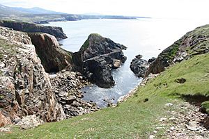
Stac Dhòmnuill Chaim, also known as Stac Dhòmhnaill Chaim, is a special old fort built on a tall rock. You can find it near a place called Mangursta on the Isle of Lewis in Scotland. This amazing rock formation and the area around it are protected as a scheduled monument. This means it's a very important historical site, like about 8,000 other places in Scotland. The name Stac Dhòmnuill Chaim comes from Donald Cam Macaulay, a local hero from the early 1600s. People wrote about this site in the late 1800s, but today it's really hard to reach. In 2003 and 2006, a team of archaeologists who are also rock climbers managed to get to the top. They explored the site and even found a piece of pottery that might be from the Stone Age!
What's in a Name?
The name Stac Dhomnuill Chaim comes from the Scottish Gaelic language. It means "One-eyed Donald's stack." A "stack" is a tall, thin rock column that stands by itself, often in the sea. This stack is a promontory fort, which means it's a fort built on a piece of land that sticks out into the sea. It's located on the west coast of the Isle of Lewis in the Outer Hebrides.
People say this stack was a safe hiding place for Donald Cam Macaulay. He was a local hero and a leader of the Macaulays of Lewis in the early 1600s. A historian named F. W. L. Thomas wrote in the 1800s that there were stories about Donald Cam's daughter, Anna Mhòr ("big Anne"). She would carry water to her father on her head because she needed her hands free to climb the very tricky path to the top!
Exploring the Site
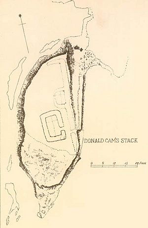
Historian F. W. L. Thomas explored Stac Dhomnuill Chaim in the late 1800s. He said the stack was about 30 meters (100 feet) high. At the very top, it was only about 6 meters (20 feet) long. He described how the stack was almost completely cut off from the land by a very deep ditch. However, a narrow rocky path still connected it to the mainland.
The stack is surrounded by the sea, so the only way to get to it was from the land side using that narrow path. Thomas mentioned that this path was protected by a thick wall, about 1.2 to 1.5 meters (4 to 5 feet) wide. This wall had a small opening or gate, about 0.6 meters (2 feet) wide, on its southern side. On top of the stack, Thomas saw the remains of a small building. It was about 5.6 meters (18.5 feet) long and 3 meters (10 feet) wide, with walls that were 1.4 meters (4.5 feet) thick. Next to this building, there were also the remains of a sheep pen.
Later Visits and Protection
In 1969, a researcher from the Ordnance Survey's Archaeology Division visited the site. By this time, the narrow path had become even more dangerous because parts of the cliff had fallen away. The site was then considered too difficult to reach. From the opposite cliff, the researcher could see that the site still looked much like Thomas had drawn it in his plans.
In 1992, Stac Dhomnuill Chaim was added to the list of scheduled monuments. This means it received special legal protection under a law called the Ancient Monuments and Archaeological Areas Act 1979. The protected area is quite large, measuring up to 200 meters (656 feet) long and 100 meters (328 feet) wide. There are about 8,000 such protected sites in Scotland. Stac Dhomnuill Chaim is listed as a "secular" site, meaning it was not used for religious purposes.
Modern Discoveries
In 2003, a team called the Severe Terrain Archaeological Campaign (STAC) visited the site. They noticed that the coast was eroding, meaning the land was slowly being worn away by the sea. They also carefully recorded the buildings on the stack.
- Building A: This was a round building made of turf and stone. It was about 2 meters (6.5 feet) across and was connected to the main wall of the fort. It didn't seem to have a clear entrance.
- Building B: This was a rectangular building, also made of turf and stone. It measured about 5 by 10 meters (16 by 33 feet) on the outside and 2 by 6 meters (6.5 by 20 feet) on the inside. It was in the middle of the stack, separated from Building A by a small gap. This building also didn't have a clear entrance.
- Wall C: This was the main wall around the edge of the stack, built from turf and stone. It went from the northern end of the stack down to the eastern side and then to the southern end. It was harder to see at the southern end, but it might have enclosed two flat areas, like terraces, on that side. There were also faint signs of an even older wall, which might mean the fort was once bigger.
Later, in 2006, a person who was a descendant of Donald Cam Macaulay joined the STAC team on another visit. During this trip, they found a large piece of pottery! Experts have since identified it as being from very early times, possibly even from the Neolithic period, which was the Stone Age.
 | DeHart Hubbard |
 | Wilma Rudolph |
 | Jesse Owens |
 | Jackie Joyner-Kersee |
 | Major Taylor |


