Stirling County, Western Australia facts for kids
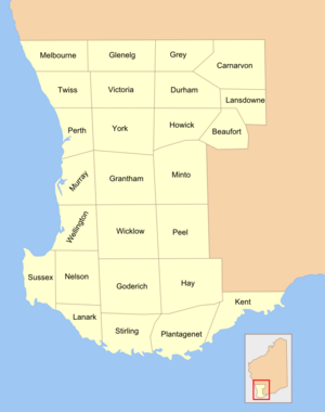
Stirling County was a special area created in Western Australia way back in 1829. It was one of 26 such areas, known as cadastral divisions. These divisions were like imaginary lines drawn on a map to help manage land. Stirling County is roughly in the southern part of a larger area called the Hay Land District. This district is still important today for keeping track of who owns which piece of land.
Contents
What is a Cadastral Division?
Imagine a giant puzzle of land. A cadastral division is like one of the puzzle pieces. These divisions are not about how people live or where towns are. Instead, they are about how land is officially measured and recorded. They help governments keep track of who owns what land. This makes it easier to buy, sell, or inherit land.
Why Were These Divisions Created?
When people first started settling in Western Australia, they needed a way to organize the land. The government wanted to give out land to new settlers. To do this fairly, they needed a system. Creating counties and other divisions in 1829 helped them manage land grants. It also made it simpler to collect taxes on land and plan for new roads or towns.
The Role of Counties in Early WA
In the early days of Western Australia, these counties were very important. They helped explorers and settlers understand where they were. They also provided a clear way to describe land for official documents. Without these divisions, it would have been very confusing to manage the vast lands of the new colony.
Where Was Stirling County Located?
Stirling County was in the southern part of Western Australia. It was part of a larger area known as the Hay Land District. This district is located in the Great Southern region. This area is known for its beautiful landscapes and farming. The county's boundaries were set up to help organize the land in this specific part of the state.
How Land Districts Work Today
Even though the original counties like Stirling are not used for everyday government anymore, the idea of land districts is still very much alive. The Hay Land District, which Stirling County was part of, continues to be important. It helps land surveyors and lawyers identify specific plots of land. This system ensures that every piece of land has a clear and unique official description.
The Legacy of Cadastral Divisions
The system of cadastral divisions, including counties, laid the groundwork for how land is managed in Western Australia even now. While the names of the counties might not be as well-known today, the principles behind them are still used. They are a reminder of how early settlers and governments organized the land for future growth and development. This historical system helps keep land records accurate and reliable for everyone.
 | Kyle Baker |
 | Joseph Yoakum |
 | Laura Wheeler Waring |
 | Henry Ossawa Tanner |


