
Tepezalá facts for kids
Quick facts for kids
Tepezalá
|
|
|---|---|
|
Municipality
|
|

Municipality location in Aguascalientes
|
|

Tepezalá
Location in Mexico
|
|
| Country | Mexico |
| State | Aguascalientes |
| Municipality | Tepezalá |
| Area | |
| • Land | 232.664 km2 (89.832 sq mi) |
| Population
(2015)
|
|
| • Total | 20,926 |
| • Density | 89.9/km2 (233/sq mi) |
Tepezalá is a town and a municipality (like a county) in the Mexican state of Aguascalientes. The town of Tepezalá is the main city for the area around it.
Tepezalá is found at the base of the eastern mountains in the state. This area has lots of minerals but not much plant life. In the 1500s, it was part of the old Silver Route. This route brought a lot of wealth to the region. It also helped explorers move into the northern parts of Mexico. The mines in Tepezalá became very famous and made the state rich.
People of Tepezalá
| Historical population | ||
|---|---|---|
| Year | Pop. | ±% |
| 2010 | 19,668 | — |
| 2015 | 20,926 | +6.4% |
| 2020 | 22,485 | +7.5% |
In 2015, a survey showed that the Tepezalá municipality had 20,926 people living there. The town of Tepezalá itself had 4,511 people in 2010.
Besides the main town, the municipality has 132 smaller communities. Here are some of the biggest ones from 2010:
- San Antonio (3,345 people) – This is considered an urban area.
- El Chayote (1,817 people) – This is a rural area.
- Carboneras (1,261 people) – This is also a rural area.
Geography and Climate
Tepezalá's Weather
| Climate data for Tepezala (1951–2010) | |||||||||||||
|---|---|---|---|---|---|---|---|---|---|---|---|---|---|
| Month | Jan | Feb | Mar | Apr | May | Jun | Jul | Aug | Sep | Oct | Nov | Dec | Year |
| Record high °C (°F) | 31.0 (87.8) |
31.5 (88.7) |
33.0 (91.4) |
37.0 (98.6) |
37.0 (98.6) |
37.0 (98.6) |
35.5 (95.9) |
34.0 (93.2) |
36.0 (96.8) |
32.5 (90.5) |
31.0 (87.8) |
35.0 (95.0) |
37.0 (98.6) |
| Mean daily maximum °C (°F) | 21.9 (71.4) |
23.7 (74.7) |
26.4 (79.5) |
29.3 (84.7) |
30.7 (87.3) |
29.8 (85.6) |
27.3 (81.1) |
27.0 (80.6) |
26.0 (78.8) |
25.7 (78.3) |
24.2 (75.6) |
22.2 (72.0) |
26.2 (79.2) |
| Daily mean °C (°F) | 12.9 (55.2) |
14.3 (57.7) |
16.8 (62.2) |
19.6 (67.3) |
21.2 (70.2) |
21.4 (70.5) |
19.8 (67.6) |
19.3 (66.7) |
18.7 (65.7) |
17.6 (63.7) |
15.1 (59.2) |
13.3 (55.9) |
17.5 (63.5) |
| Mean daily minimum °C (°F) | 3.8 (38.8) |
5.0 (41.0) |
7.2 (45.0) |
9.9 (49.8) |
11.8 (53.2) |
12.9 (55.2) |
12.2 (54.0) |
11.6 (52.9) |
11.4 (52.5) |
9.5 (49.1) |
6.0 (42.8) |
4.5 (40.1) |
8.8 (47.8) |
| Record low °C (°F) | −11.0 (12.2) |
−2.0 (28.4) |
−2.0 (28.4) |
0.0 (32.0) |
1.0 (33.8) |
4.5 (40.1) |
5.0 (41.0) |
4.0 (39.2) |
2.0 (35.6) |
1.0 (33.8) |
−2.0 (28.4) |
−5.5 (22.1) |
−11.0 (12.2) |
| Average precipitation mm (inches) | 16.1 (0.63) |
10.3 (0.41) |
5.4 (0.21) |
6.9 (0.27) |
19.4 (0.76) |
59.3 (2.33) |
113.5 (4.47) |
94.6 (3.72) |
74.3 (2.93) |
27.4 (1.08) |
8.1 (0.32) |
11.8 (0.46) |
447.1 (17.60) |
| Average precipitation days (≥ 0.1 mm) | 2.0 | 1.4 | 1.0 | 1.2 | 2.7 | 7.0 | 10.3 | 9.5 | 7.1 | 3.5 | 1.2 | 1.7 | 48.6 |
| Source: Servicio Meteorologico Nacional | |||||||||||||
Images for kids
-
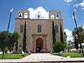
This is the front of the Our Lady of Refuge Temple.
-
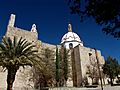
A side view of the Our Lady of Refuge Temple.
-

Inside the Our Lady of Refuge Temple.
-
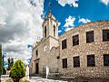
The Sanctuary of the Lord of Tepezalá.


See also
 In Spanish: Tepezalá (Aguascalientes) para niños
