
Thatta District facts for kids

Thatta District (Urdu: ضلع ٹھٹہ, Sindhi: ضلع ٺٽو) is a region found in the Sindh province of Pakistan. It is known for its rich history and interesting places. According to a count done in 1998, about 1,113,194 people lived there. About 11% of these people lived in cities and towns, while most lived in smaller villages.
Contents
What is Thatta District?
Thatta District is one of the many important areas that make up the country of Pakistan. It is located in the southeastern part of the Sindh province. This district has a long and fascinating past, with many old buildings and stories to tell. It is a place where you can learn about the history and culture of the region.
How Thatta District is Divided
Like many large areas, Thatta District is split into smaller parts to help manage it better. These smaller parts are called Tehsils. Each Tehsil is like a sub-district, with its own towns and villages. Here are the Tehsils that make up Thatta District:
- Ghora Bari Tehsil
- Jati Tehsil
- Mirpur Bathoro Tehsil
- Mirpur Sakro Tehsil
- Shah Bander Tehsil
- Sujawal Tehsil
- Thatta (This is also the name of a city within the district)
- Kharo Chan Tehsil
- Keti Bander Tehsil
Interesting Places in Thatta District
Thatta District is home to several historical and cultural sites. These places show the district's long history and its importance in the past. One such place is a shrine that is very old.
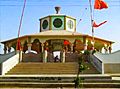
Mamaidev Astan Shrine
One notable site is the Mamaidev Astan shrine. This special place dates back to the 13th century. It is a significant historical and religious site in the district. People visit it to learn about its history and importance.
Images for kids
-
Mamaidev Astan is a 13th century shrine

