The Frith facts for kids
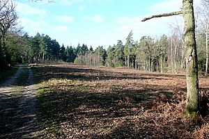
The Frith is a small, ancient fort found in Hampshire, England. It was built during the Iron Age, a time when people used iron tools and weapons. This fort is called a "hillfort" because it was built on a hill for protection. It's located north of Silchester, which was once a big Roman town called Calleva Atrebatum.
The Frith hillfort has a single protective wall, or "bank," that goes all the way around it, except for the southeast side. This bank is about 5 feet (1.5 m) (1.5 meters) high on its western edge. There's also a ditch that runs along the bank, which would have made it even harder for enemies to get in.
The land around the fort to the north and northwest has some woods. A walking path crosses through the site from east to west. The ground slopes from about 90 to 95 metres (295 to 312 ft) (295 to 312 feet) above sea level in the west. The very top of the unnamed hill nearby is about 102 metres (335 ft) (335 feet) above sea level, located about 500 metres (1,600 ft) (1,640 feet) to the southwest. A Roman road that led to Calleva Atrebatum is also close by to the south. About 500 metres (1,600 ft) (1,640 feet) to the west, there's another smaller, mysterious enclosed area.
Where is The Frith Hillfort?
The Frith hillfort is located inside an area called Benyon's Inclosure. This is north of Silchester, which is part of the Mortimer West End Civil Parish in the county of Hampshire. You can find its exact spot using these coordinates:
- Map sources for The Frith
 | Aaron Henry |
 | T. R. M. Howard |
 | Jesse Jackson |


