Tierra Blanca, Cartago facts for kids
Quick facts for kids
Tierra Blanca
|
|
|---|---|
|
District
|
|

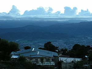
View from Tierra Blanca
|
|
| Country | |
| Province | Cartago |
| Canton | Cartago |
| Creation | 5 December 1919 |
| Area | |
| • Total | 12.75 km2 (4.92 sq mi) |
| Elevation | 2,080 m (6,820 ft) |
| Population
(2011)
|
|
| • Total | 5,103 |
| • Density | 400.24/km2 (1,036.6/sq mi) |
| Time zone | UTC−06:00 |
| Postal code |
30108
|
Tierra Blanca is a district in the Cartago canton. It is located in the Cartago province of Costa Rica.
Contents
History of Tierra Blanca
Tierra Blanca became an official district on December 5, 1919. This happened because of a special government rule.
Where is Tierra Blanca?
Tierra Blanca covers about 12.75 square kilometers. It sits high up, about 2,080 meters (6,824 feet) above sea level. This district is located just 3 miles north of Cartago city. It rests on the side of a big mountain. The top of this mountain is the famous Irazú Volcano.
How Many People Live Here?
| Historical population | |||
|---|---|---|---|
| Census | Pop. | %± | |
| 1927 | 1,102 | — | |
| 1950 | 1,819 | 65.1% | |
| 1963 | 2,284 | 25.6% | |
| 1973 | 2,656 | 16.3% | |
| 1984 | 3,527 | 32.8% | |
| 2000 | 4,639 | 31.5% | |
| 2011 | 5,103 | 10.0% | |
|
Instituto Nacional de Estadística y Censos |
|||
According to the 2011 census, Tierra Blanca had 5,103 people living there.
Getting Around Tierra Blanca
Road Connections
The district has one main road that helps people travel.
What People Do in Tierra Blanca
Tierra Blanca is a small farming community. Most of its 5,000 residents are of Spanish background. People here mainly grow potatoes, onions, and carrots. Some farmers also grow strawberries. The weather is cool compared to other parts of Costa Rica.
See also
 In Spanish: Tierra Blanca (Costa Rica) para niños


