
Tierra del Fuego National Park facts for kids
Quick facts for kids Tierra del Fuego National Park |
|
|---|---|
| Parque Nacional Tierra del Fuego | |
|
IUCN Category II (National Park)
|
|
 |
|

Tierra del Fuego National Park
Location in Argentina
|
|
| Location | Tierra del Fuego Province, Argentina |
| Nearest city | Ushuaia |
| Area | 630 km2 (243 sq mi) |
| Established | 15 October 1960 |
| Governing body | Administración de Parques Nacionales |
Tierra del Fuego National Park (in Spanish: Parque Nacional Tierra del Fuego) is a special nature park in Argentina. It's located on the island of Tierra del Fuego, which is at the very southern tip of South America. This park was created on October 15, 1960. It was the first national park in Argentina that included a coastline!
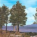
The park is famous for its amazing views. You can see beautiful waterfalls, thick forests, tall mountains, and even glaciers. It covers about 630 square kilometers (243 square miles). This area includes parts of two large lakes, Fagnano and Roca. A popular walking path called the Senda Costera (Coastal Path) connects Ensenada Bay to Lapataia Bay.
Many animals live in the park's forests. These forests have trees like Antarctic beech and lenga beech. You might spot guanacos, Andean foxes, beavers, or rabbits. There are also many birds, such as the kelp goose, torrent duck, and the huge Andean condor.
Tierra del Fuego National Park is the southernmost national park in Argentina. It stretches about 60 kilometers (37 miles) north from the Beagle Channel, right along the border with Chile. The city of Ushuaia, the capital of Tierra del Fuego Province, is only about 11 kilometers (7 miles) away. You can get to the park by car or by a special train called the End of the World Train.

Contents
Exploring Tierra del Fuego's Nature
This park is part of a unique forest type called the subantarctic forest. It's known for having many different kinds of plants and animals.
Plants of the Park
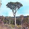
The forests here are mostly made up of three types of beech trees: coihue, nires, and lenga. Lenga trees grow well on the mountain slopes up to about 600 meters (2,000 feet) high. Above that height, you'll find smaller bushes, cushion plants, and grasses.
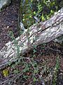
Other plants in the park include different types of berries like calafate and chaura. You might also see the winter's bark tree and crowberry. In the wettest areas near the Beagle Channel, you can find Magellan coihue trees.
The park also has many peat bogs. These are like spongy, wet areas made of moss and water grasses. They form in damp valleys where it's cold and the water is slow-moving and acidic. This keeps dead plants from breaking down quickly.
Look out for colorful flowers too! There are orange michay flowers, little ferns, yellow orchids, and luzuriagas. Along the Beagle Channel, you might see black bushes and plants with red, tube-shaped flowers.
- Flora in Tierra del Fuego
-
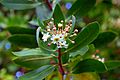
Drimys winteri flowers
-
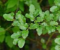
Nothofagus antarctica
-
Nothofagus pumilio
-
Nothofagus betuloides
-
Calafate (Berberis buxifolia) plant west of Ushuaia


Animals of the Park
Over time, some animals were brought to this area by people. These include European rabbits, North American beavers, and muskrats. These animals grew in number very quickly and caused some damage to the environment.
The park is home to many birds. You can see different kinds of geese, like the upland goose and kelp goose, especially in open areas and on beaches. Other birds include Patagonian woodpeckers, herons, and crested ducks. The huge Andean condors can be seen flying high above the peaks. The austral parakeet, a type of parrot, also lives here. It's the southernmost parrot species in the world!
In the water, you might find scallops, crabs, and fish like sardines and merluza. Sea lions are also seen in the park. If you're lucky, you might spot petrels and albatrosses flying over the sea. Several types of penguins, the South Andean deer, and the southern river otter also live here.
- Fauna in Tierra del Fuego
-
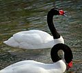
A pair of black-necked swans in the park
-
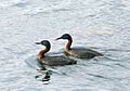
Podiceps major – great grebe- Tierra del Fuego National Park
-
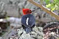
A Magellanic woodpecker (Campephilus magellanicus) near Ushuaia
-
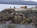
Sea lions at the Beagle Channel near Ushuaia
-
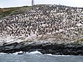
Cormorant colony on the shores of the Beagle Channel


.jpg)


Park Features and Landscapes
Tierra del Fuego National Park has a mix of mountains, lakes, rivers, and valleys. It borders Chile to the west, Lago Fagnano to the north, and the Beagle Channel to the south. The park covers about 63,000 hectares (155,670 acres).
The landscape here was shaped by glaciers long ago. They carved out the bays and beaches you see today, with rugged mountains and valleys in the background.

The park is located about 11 kilometers (7 miles) west of the city of Ushuaia. You can reach it by driving on National Road 3 or by taking the Southern Fuegian Railway.
The Beagle Channel
The Beagle Channel is a famous strait in the park. It's named after the British ship HMS Beagle, which sailed here with the famous naturalist Charles Darwin in 1833–34. This channel separates the main island of Tierra del Fuego from smaller islands to the south.
It stretches for about 150 miles (240 km) from east to west. Its width changes from 3 to 8 miles (5 to 13 km). Ushuaia in Argentina and Puerto Williams in Chile are two of the southernmost towns in the world located on this channel. You can still see ancient shell piles (middens) on the beaches. These were left by the Yaghan people, who lived here long ago.
Lago Fagnano


Lago Fagnano, also called Cami Lake, is the largest lake in Tierra del Fuego. It's one of the southernmost large lakes outside of Antarctica! This lake flows south into the Magellan Strait.
The lake is located on an active tectonic plate boundary. This means the Earth's plates are moving here. Most of the lake is in Argentina, with a small part in Chile. It was formed by glaciers during the Pliocene and Pleistocene eras. The lake is very deep, with an average depth of about 70 meters (230 feet) and a maximum depth of 204 meters (670 feet).
Climate of the Park
The park has a mild climate with frequent rain, fog, and strong winds. Winds from the west keep the weather fairly steady. The park gets about 700 millimeters (27.5 inches) of rain each year. The most rain (or snow at higher places) falls from March to May. There isn't a dry season here.
Average temperatures are around 0°C (32°F) in winter and 10°C (50°F) in summer. In Ushuaia, the average yearly temperature is about 5.4°C (41.7°F).
History of Tierra del Fuego

Why "Land of Fire"?
When the first Europeans explored the southern tip of South America, they saw many campfires. These fires belonged to the native people of the area, called the Yaghan (or Yámana) people. Because of all the fires, the Spanish explorers named the area "Tierra del Fuego," which means "Land of Fire" in Spanish.
Ancient Inhabitants
Humans have lived in Tierra del Fuego for at least 10,000 years. The Yaghan people lived in this tough environment by using the sea's resources. They built canoes from lenga beech trees, hunted sea lions, and gathered shellfish. Their homes were huts made of tree branches and trunks. They wore clothes made from sea lion skins and used animal fat to keep their skin waterproof.
Later History
In the 1880s, many gold prospectors came to Ushuaia because they heard rumors of gold. But these rumors turned out to be false.
Life became very difficult for the Yaghan people after Europeans arrived. European settlers brought diseases like measles, which caused the Yaghan population to shrink very quickly. Their numbers dropped from about 3,000 people in 1880 to less than 100 by the 1990s. Today, only one native speaker of the Yaghan language remains. You can still see piles of mussel shells near the seashore, which are relics of the Yaghan settlements. Some of their ancient items are also displayed in the "End of the World Museum" in Ushuaia.
In 1881, Argentina and Chile tried to settle their border dispute. They agreed that Tierra del Fuego would be divided, with Argentina getting the eastern part and Chile the western part. However, this agreement led to more arguments, especially about some small islands. The dispute almost caused a war in 1978, but the Vatican helped solve the problem peacefully in 1985. Chile kept control of the disputed islands, and Argentina gained navigation rights.
In 1902, an Argentine president started a prison colony on a nearby island. Prisoners were used as workers to build the city of Ushuaia and to cut down trees in what is now Tierra del Fuego National Park. They also built the train lines. Ushuaia is now a popular place for tourists, as it's a starting point for visiting the park and even for trips to Antarctica.
The railway line, known as the Southern Fuegian Railway or the End of the World Train, was built in the early 1900s. It was first used to transport prisoners and timber from the forests. Because of this, it was called the "Prison train." The prison closed in 1947, and the railway stopped running in 1952 after an earthquake damaged the tracks.
Visiting the Park
There are many interesting places to see in Tierra del Fuego National Park. These include the Beagle Channel, the Pipo River waterfall, Lago Fagnano, Lago Roca, Ensenada Bay, Lapataia Bay, the End of the World Train, and Laguna Negra.
The End of the World Train

In 1994, the End of the World Train was brought back to life! It had been closed for 40 years. The train was fixed up with modern comforts and became a heritage train. It's now known as the southernmost working railway in the world.
You can take this train from the Fin del Mundo station, just outside Ushuaia. The train ride covers about 5 kilometers (3 miles) and takes about 50 minutes. It's a fun way to see parts of the park.
See also
 In Spanish: Parque nacional Tierra del Fuego para niños
- Treaty of Peace and Friendship of 1984 between Chile and Argentina
