
Timeline of town creation in Central New York facts for kids
The towns and cities of Central New York were created by the state of New York to help local people have more say in how their communities are run. Central New York is a large area made up of six counties: Cayuga, Herkimer, Madison, Oneida, Onondaga, and Oswego. It includes the bigger cities of Syracuse and Utica-Rome.
For a long time, this area was controlled by the Iroquois Confederacy. After 1777, it became part of New York State. The land was first part of a very large county called Albany County. Later, it became part of Tryon County, which was renamed Montgomery County. As New York grew, these big counties were split into smaller ones. For example, Onondaga County was created from Herkimer County in 1794. Then, Cayuga County was formed from Onondaga in 1799. Madison County was created in 1806, and Oswego County in 1816.
New York State tried different ways to organize its local areas. Eventually, it settled on the system we have today: towns and cities. These towns and cities cover all the land within a county. In 1788, the entire state was divided into towns. At first, towns were just ways for the state to manage things better. But in 1964, towns gained "home rule" powers. This means they could make more of their own decisions about local government and public services.
Contents
How Towns and Cities Were Formed in Central New York
The way towns and cities were created in Central New York is a bit like a family tree. Older, larger areas were split into smaller ones over time. This section explains how some of these changes happened in each county.
Cayuga County's Beginnings

Cayuga County was formed from Onondaga County in 1799. Before that, much of this land was part of a special area called the Military Tract. This tract was divided into 25 "townships" to give land to soldiers who fought in the American Revolutionary War. These townships were later combined into towns. For example, in 1794, the townships of Milton, Locke, Scipio, Sempronius, Cato, Brutus, and Aurelius were combined to form the towns of Milton, Scipio, and Aurelius in what is now Cayuga County.
Herkimer County's Development
Herkimer County was formed in 1791. Many of its towns grew from older areas called "districts" or "precincts" that were part of Montgomery County. For instance, the German Flatts District, created in 1772, became the town of German Flatts in 1788. Over the years, towns like Frankfort (1796), Warren (1796), and Litchfield (1796) were created from German Flatts. Later, smaller towns like Columbia (1812) were formed from Warren. The city of Little Falls was once part of the town of Little Falls, which was created in 1829.
Madison County's Growth
Madison County was created in 1806 from Chenango County. Many of its towns were first part of Whitestown, which was a very large town created in 1788. Whitestown was split into many new towns. For example, Cazenovia was formed from Whitestown in 1795. Later, Nelson (1807), Smithfield (1807), and Fenner (1823) were created from Cazenovia. Other towns like Hamilton (1795) and Brookfield (1795) were formed from Paris. The city of Oneida was once a town, created in 1896, before becoming a city in 1901.
Oneida County's Formation

Oneida County was created in 1798 from Herkimer County. Like Madison County, many of its towns started as part of the huge Whitestown. Utica, a major city in Oneida County, was first a town created in 1817 before becoming a city in 1832. Rome, another important city, was a town from 1796 to 1870 before becoming a city. Towns like Steuben (1792), Leyden (1797), and Boonville (1805) were formed from older areas. The city of Sherrill is unique because it is sometimes considered a village under the town of Vernon, even though it's a city.
Onondaga County's Evolution

Onondaga County was created in 1794 from Herkimer County. It was one of the first counties formed from the Military Tract. Many of its towns, like Pompey (1794), Marcellus (1794), and Manlius (1794), were created right when the county was formed. Over time, these towns were split further. For example, Fabius (1798) and Tully (1803) were created from Pompey. The city of Syracuse was once part of the town of Manlius before becoming a city in 1847.
Oswego County's Development

Oswego County was created later, in 1816, from parts of Onondaga and Oneida counties. Many of its towns were formed from the large towns of Lysander and Mexico. For example, Hannibal (1806) was created from Lysander, and Granby (1818) was created from Hannibal. The city of Fulton was once part of the town of Granby before becoming a city in 1902. The town of Oswego (1818) and the city of Oswego (1848) also developed from earlier divisions.
Images for kids
-
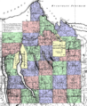
The Military Tract of Central New York (1792).

